Morningside, Auckland

Last updated

Morningside
Morningside shops, 2014.jpg
Morningside shops, as seen from the corner of New North Road and Morningside Drive.
Morningside, Auckland
Coordinates: 36°52′44″S174°43′58″E / 36.878830°S 174.732731°E / -36.878830; 174.732731
CountryNew Zealand
City Auckland
Local authority Auckland Council
Electoral ward Albert-Eden-Puketāpapa ward
Local board Albert-Eden Local Board
Area
[1]
  Land109 ha (269 acres)
Population
 (June 2023) [2]
  Total3,920
Train stations Morningside railway station
Point Chevalier Western Springs Grey Lynn
Mount Albert
Pfeil oben.svg
Pfeil links.svgMorningsidePfeil rechts.svg
Pfeil unten.svg
Kingsland
Mount Albert St Lukes Mount Eden

Morningside is a suburb of Auckland, New Zealand. It lies four kilometres south-west of the city centre, close to Eden Park and Western Springs Reserve.

Contents

Geography

Original 1865 plan for Morningside, including the central church Morningside to be sold by auction (cropped).jpg
Original 1865 plan for Morningside, including the central church
Morningside seen from Owairaka / Mount Albert in 1926 Auckland panorama from Mount Albert, 1926 (cropped to Morningside).jpg
Morningside seen from Ōwairaka / Mount Albert in 1926

Morningside is a suburb on the western Auckland isthmus, located south of the Northwestern Motorway. It is bisected by New North Road and the Western Line. Morningside lies between the suburbs of Grey Lynn, Kingsland, Sandringham, St Lukes, Mount Albert and Point Chevalier.

History

The broader area was originally swampland, and known to Tāmaki Māori as Ngā Anawai, referring to the water-filled lava-flow caves that formed in the area. The lava caves were created by Maungawhau / Mount Eden and Mount Albert over 30,000 years ago. [3] [4]

On 29 June 1841, the Mount Albert area was sold to the Crown by Ngāti Whātua, as a part of a 12,000 acre section. [5] The terrain of the area was rough, meaning the area saw slower development compared to other parts of the Auckland isthmus. [6] In the 1860s, New North Road was established as road access for the area and as an alternative to the Great North Road to the north. [7] Allan Kerr Taylor, a major landowner in the Mount Albert area, auctioned off a section of his land in March 1865 to create a subdivision along the road. Kerr Taylor named the new village Morningside, referencing Morningside in North Lanarkshire, Scotland, which was the location of a mental asylum. [8] Kerr Taylor's original plan for the village included a church to be built on an island in the middle of New North Road. [9]

Morningside railway station opened in March 1880, connecting Morningside to Auckland city by rail. [10] Morningside saw slower growth compared to Kingsland, located closer to the city. In March 1910, the Shawville housing estate in Morningside was sold off. [11]

Morningside grew as a community after the tramline extended to the suburb along New North Road in 1912. [12]

The suburb is centred on the Morningside shops which are located on the New North Road, near the Morningside railway station. One of Morningside's largest buildings is the 1920s brick building which formerly housed the Mount Albert Borough Council until Mt Albert was amalgamated with Auckland City in the late 1980s.

Morningside was the setting of the animated TV show Bro'Town, and also the album title and hometown of Fazerdaze.

Demographics

Morningside (Auckland) covers 1.09 km2 (0.42 sq mi) [1] and had an estimated population of 3,920 as of June 2023, [2] with a population density of 3,596 people per km2.

Historical population
YearPop.±% p.a.
20063,606    
20133,825+0.85%
20183,981+0.80%
Source: [13]

Morningside (Auckland) had a population of 3,981 at the 2018 New Zealand census, an increase of 156 people (4.1%) since the 2013 census, and an increase of 375 people (10.4%) since the 2006 census. There were 1,320 households, comprising 1,986 males and 1,995 females, giving a sex ratio of 1.0 males per female. The median age was 32.5 years (compared with 37.4 years nationally), with 495 people (12.4%) aged under 15 years, 1,206 (30.3%) aged 15 to 29, 2,049 (51.5%) aged 30 to 64, and 231 (5.8%) aged 65 or older.

Ethnicities were 68.6% European/Pākehā, 9.0% Māori, 10.2% Pacific peoples, 21.9% Asian, and 3.8% other ethnicities. People may identify with more than one ethnicity.

The percentage of people born overseas was 37.9, compared with 27.1% nationally.

Although some people chose not to answer the census's question about religious affiliation, 53.2% had no religion, 27.8% were Christian, 0.1% had Māori religious beliefs, 5.9% were Hindu, 2.8% were Muslim, 2.0% were Buddhist and 3.6% had other religions.

Of those at least 15 years old, 1,593 (45.7%) people had a bachelor's or higher degree, and 204 (5.9%) people had no formal qualifications. The median income was $46,000, compared with $31,800 nationally. 936 people (26.9%) earned over $70,000 compared to 17.2% nationally. The employment status of those at least 15 was that 2,265 (65.0%) people were employed full-time, 477 (13.7%) were part-time, and 165 (4.7%) were unemployed. [13]

Amenities and attractions

Fowlds Park Picnic Tables in Fowlds Park - 4627856301.jpg
Fowlds Park

Education

Mount Albert School is a contributing primary school (years 1-6) with rolls of 404. [17] The local state intermediate school is Kōwhai Intermediate School, while the local secondary schools include Mount Albert Grammar School and Marist College.

Local government

In October 1866, the Mt Albert District Highway Board, the first local government in the area, was formed to administer New North Road and the surrounding areas. [7] In 1911, the board became the Mount Albert Borough, who elected a mayor. [18] In 1978, Mount Albert became a city, [19] and in 1989 it was absorbed into Auckland City. [20] In November 2010, all cities and districts of the Auckland Region were amalgamated into a single body, governed by the Auckland Council. [21]

Morningside is a part of the Albert-Eden local board area. The residents of Albert-Eden elect a local board, and two councillors from the Albert-Eden-Puketāpapa ward to sit on the Auckland Council.

Related Research Articles

<span class="mw-page-title-main">Mount Eden</span> Suburb in Auckland, New Zealand

Mount Eden is a suburb in Auckland, New Zealand whose name honours George Eden, 1st Earl of Auckland. It is 4 kilometres (2.5 mi) south of the Central Business District (CBD). Mt Eden Road winds its way around the side of Mount Eden Domain and continues to weave back and forth as it descends into the valley; it runs south from Eden Terrace to Three Kings. Mt Eden village centre is located roughly between Valley Road and Grange Road. The domain is accessible on foot from many of the surrounding streets, and by vehicle from Mt Eden Road. The central focus of the suburb is Maungawhau / Mount Eden, a dormant volcano whose summit is the highest natural point on the Auckland isthmus.

<span class="mw-page-title-main">Point Chevalier</span> Suburb in Auckland, New Zealand

Point Chevalier is a residential suburb and peninsula in the city of Auckland in the north of New Zealand. It is located five kilometres to the west of the city centre on the southern shore of the Waitematā Harbour. The suburb was originally a working-class area, with some state houses in the area, but over the past several decades the suburb has seen growth into becoming a middle-class suburb, with several redevelopment projects either completed or underway. Like most of the suburbs surrounding, Point Chevalier is known for its Californian style bungalows.

<span class="mw-page-title-main">Mount Albert, New Zealand</span> Suburb in Auckland, New Zealand

Mount Albert is an inner suburb of Auckland, New Zealand, which is centred on Ōwairaka / Mount Albert, a local volcanic peak which dominates the landscape. By 1911, growth in the area had increased to the point where Mount Albert was declared an intdependent borough, which was later absorbed into Auckland. The suburb is located 7 kilometres (4.3 mi) to the southwest of the Auckland City Centre.

<span class="mw-page-title-main">Mount Roskill</span> Suburb in Auckland, New Zealand

Mount Roskill is a suburban area in the city of Auckland, New Zealand. It is named for the volcanic peak Puketāpapa.

<span class="mw-page-title-main">Western Springs (Auckland suburb)</span> Suburb in Auckland, New Zealand

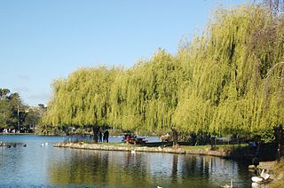
Western Springs is a residential suburb in the city of Auckland in the north of New Zealand. It is located four kilometres to the west of the city centre, Auckland CBD. The park is situated to the north of State Highway 16 and the residential suburb is located southeast of the park on the opposite side of State Highway 16.

<span class="mw-page-title-main">Sandringham, New Zealand</span> Suburb in Auckland, New Zealand

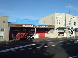
Sandringham is a suburb of Auckland, New Zealand. It is a multi-ethnic suburb with a population of over 12,000.

<span class="mw-page-title-main">Wesley, New Zealand</span> Suburb in Auckland, New Zealand

Wesley is a suburb of Auckland, New Zealand, located in the south-west of the Auckland isthmus. The area is a part of the Oakley Creek catchment, and in the 19th and early 20th centuries was primarily swampland owned by the Weslayan Mission. The New Zealand Government developed Wesley as a state housing area in the 1940s and 1950s.

<span class="mw-page-title-main">Ōwairaka</span> Suburb in Auckland, New Zealand

Ōwairaka is a suburb of New Zealand's largest city, Auckland. It is under the local governance of the Auckland Council. The area was primarily rural until the 1930s, when the area experienced suburban growth. Ōwairaka is known for the Owairaka Athletic Club, a club that came to prominence in the 1960s, due to the success of coach Arthur Lydiard and athletes Murray Halberg and Peter Snell.

<span class="mw-page-title-main">Kingsland, New Zealand</span> Suburb in Auckland, New Zealand

Kingsland is an inner-city suburb of Auckland, the largest and most populous urban area in New Zealand. Kingsland is under the local governance of the Auckland Council. It is the home of Eden Park, New Zealand's largest stadium, which hosted the finals for the 2011 Rugby World Cup. Kingsland has a village centre that contains a series of shops, restaurants, pubs and monthly markets.

<span class="mw-page-title-main">Dominion Road</span>

Dominion Road is an arterial road in Auckland, New Zealand, running north–south across most of the Auckland isthmus. It is a major public transport route that carries 50,000 bus passengers each week, making it one of the few roads in Auckland on which similar or greater numbers of people travel by public transport than by private car.

<span class="mw-page-title-main">Albert-Eden Local Board</span> Local board of Auckland Council in New Zealand

The Albert-Eden Local Board is one of the 21 local boards of the Auckland Council, and is one of the two boards overseen by the council's Albert-Eden-Puketāpapa ward councillors.

<span class="mw-page-title-main">Ōwairaka / Mount Albert</span> Scoria cone in Auckland, New Zealand

Ōwairaka / Mount Albert, also known as Te Ahi-kā-a-Rakataura, is a volcanic peak and Tūpuna Maunga which dominates the landscape of the Ōwairaka and Mount Albert suburbs of Auckland.

<span class="mw-page-title-main">Eden Valley, New Zealand</span> Suburb in Auckland Council, New Zealand

Eden Valley is an inner-city suburb of Auckland, the largest and most populous urban area in New Zealand. The suburb grew around Dominion Road, one of the Auckland's main arterial routes. Eden Valley's commercial hub is made up of a collection of businesses, shops, and dining options that service the area. The eclectic collection of shop fronts and signage on Dominion Road has aptly been described as, "colour and chaos". The "colour and chaos" of the commercial hub is strongly contrasted by the surrounding residential area. Eden Valley is characterized by heritage buildings that house modern day businesses, a residential area that has a range of late Victorian, Edwardian and transitional bay villas, and basalt and scoria stone walls that give the area a long established feel.

Edward George Bollard was a New Zealand plant physiologist and science administrator.

<span class="mw-page-title-main">Albert-Eden</span> Local board area in Auckland, New Zealand

Albert-Eden is a local government area in Auckland, in New Zealand's Auckland Region. It is governed by the Albert-Eden Local Board and Auckland Council, and is located within the council's Albert-Eden-Puketāpapa Ward.

<span class="mw-page-title-main">Kōwhai Intermediate School</span> School

Kōwhai Intermediate School is a state co-educational intermediate school located in the suburb of Kingsland in Auckland, New Zealand. The school opened in October 1922, and was the first intermediate school in New Zealand.

<span class="mw-page-title-main">New North Road, New Zealand</span> Street in Auckland, New Zealand

New North Road is a street in the central and western Auckland isthmus, New Zealand, connecting Upper Symonds Street in Eden Terrace to Avondale. The road runs parallel to Great North Road, located to the north, and crosses Dominion Road, the Western Line at Morningside and runs above the Waterview Tunnel section of the Southwestern Motorway at Mount Albert.

<span class="mw-page-title-main">Gribblehirst Park</span> Park in Auckland, New Zealand

Gribblehirst Park is a park in central Auckland, New Zealand, close to the suburbs of Sandringham and Morningside. Originally the park was known as Cabbage Tree Swamp.

<span class="mw-page-title-main">Ferndale House</span> Historic house in Auckland, New Zealand

Ferndale House is a 19th-century house in Mount Albert, Auckland, New Zealand, which is listed by Heritage New Zealand as a Category II structure. The house was built in the 1860s for the Garlick family, major figures in the Methodist community in Mount Albert, later becoming a hub for the Plunket Society in the 1940s and a community centre.

<span class="mw-page-title-main">St Lukes, New Zealand</span> Suburb in Auckland, New Zealand

St Lukes is a suburb of New Zealand's largest city, Auckland. It is under the local governance of the Auckland Council. After Westfield St Lukes opened in 1972, the area developed into a major commercial area of the Auckland isthmus.

References

  1. 1 2 "ArcGIS Web Application". statsnz.maps.arcgis.com. Retrieved 12 July 2022.
  2. 1 2 "Population estimate tables - NZ.Stat". Statistics New Zealand . Retrieved 25 October 2023.
  3. Ngāti Whātua Ōrākei; Truttman, Lisa (2009). "Balmoral & Sandringham Heritage Walks" (PDF). Auckland Council . Retrieved 1 September 2021.
  4. "Gribblehirst Park". Auckland Council . Retrieved 22 March 2023.
  5. Dunsford 2016, p. 19.
  6. Dunsford 2016, p. 25.
  7. 1 2 Dunsford 2016, pp. 26–29.
  8. "Morningside". New Zealand Gazetteer. Land Information New Zealand. Retrieved 22 March 2023.
  9. Dunsford 2016, p. 28.
  10. Scoble, Juliet (2010). "Names & Opening & Closing Dates of Railway Stations" (PDF). Rail Heritage Trust of New Zealand. Retrieved 11 November 2018.
  11. Dunsford 2016, pp. 54–56.
  12. Dunsford 2016, pp. 54–56, 84.
  13. 1 2 "Statistical area 1 dataset for 2018 Census". Statistics New Zealand. March 2020. Morningside (Auckland) (133600). 2018 Census place summary: Morningside (Auckland)
  14. "New Church at Morningside". The New Zealand Herald . Vol. XLVIII, no. 14589. 27 January 1911. p. 8. Retrieved 22 March 2023 via Papers Past.
  15. Templeton, Sarah (8 November 2018). "Morningside's multi-million dollar development set to open". Newshub. Retrieved 22 March 2023.
  16. Dunsford 2016, p. 43.
  17. Education Counts: Mount Albert School
  18. Dunsford 2016, p. 79.
  19. Dunsford 2016, p. 119.
  20. Dunsford 2016, p. 200.
  21. Blakeley, Roger (2015). "The planning framework for Auckland 'super city': an insider's view". Policy Quarterly. 11 (4). doi: 10.26686/pq.v11i4.4572 . ISSN   2324-1101.

Bibliography