
Oxford is a city in England. It is the county town and only city of Oxfordshire. In 2020, its population was estimated at 151,584. It is located 56 miles (90 km) north-west of London, 64 miles (103 km) south-east of Birmingham and 61 miles (98 km) north-east of Bristol. The city is home to the University of Oxford, the oldest university in the English-speaking world; it has buildings in every style of English architecture since late Anglo-Saxon. Oxford's industries include motor manufacturing, education, publishing, information technology and science.

Oxford Brookes University is a public university in Oxford, England. It is a new university, having received university status through the Further and Higher Education Act 1992. It can trace its origins to 1865, when it was founded as the Oxford School of Art. The university was named after its first principal, John Henry Brookes, who played a major role in the development of the institution.
Chiang Yee, self-styled as "The Silent Traveller" (哑行者), was a Chinese poet, author, painter and calligrapher. The success of The Silent Traveller in London (1938) was followed by a series of books in the same vein, all of which he illustrated himself.

Headington is an eastern suburb of Oxford, England. It is at the top of Headington Hill overlooking the city in the Thames valley below, and bordering Marston to the north-west, Cowley to the south, and Barton and Risinghurst to the east. The life of the large residential area is centred upon London Road, the main road between London and Oxford.

Headington School is an independent girls' school in Headington, Oxford, England, founded by a group of evangelical Christians in 1915. The Good Schools Guide called Headington "A delightful school, [which] nurtures and entertains its pupils while at the same time achieving excellent academic results... fun and stimulating to be at."

St Clement's is a district in Oxford, England, on the east bank of the River Cherwell. "St Clement's" is usually taken to describe a small triangular area from The Plain bounded by the Cherwell in the West, Cowley Road in the East. to the foot of Headington Hill in the South. It also refers to the ecclesiastical parish of St Clement's which includes some neighbouring areas and is used in the names of local City and County electoral districts.

Marston Road is a road in the east of Oxford, England. It links London Place, the junction of St Clements, the foot of Headington Hill, and Morrell Avenue by South Park to the south with the suburb of New Marston to the north. A mini-roundabout has been replaced by traffic lights and connects with Cherwell Drive and Headley Way at the northern end. To the north is the suburb of Northway. The road is designated the B4150 but this is not shown on signs.

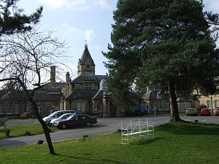
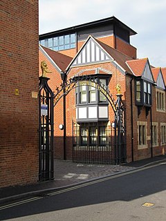
Headington Hill Hall stands on Headington Hill in the east of Oxford, England. It was built in 1824 for the Morrell family, who remained in residence for 114 years. It became the home to Pergamon Press and to media tycoon Robert Maxwell. It currently houses Oxford Brookes School of Law.

Headington Hill is a hill in the east of Oxford, England, in the suburb of Headington. The Headington Road goes up the hill leading out of the city. There are good views of the spires of Oxford from the hill, especially from the top of South Park.
Headington Road is an arterial road in the east of Oxford, England. The road connects the junction of St Clements and Marston Road with the suburb of Headington, up Headington Hill. When it reaches the Headley Way junction, it becomes London Road, as the Boundary Brook runs under the road at this point.
The Oxford Ring Road circles the city of Oxford, England. It is a dual carriageway ring road for most of its length apart from a short section between Woodstock Road and Banbury Road in the north of the city. The severe restrictions on traffic in Oxford city centre mean that it is the only practical way for long-distance traffic to get past Oxford, especially as there are few road bridges over the rivers Isis and Cherwell. Five Park and Rides are close to the ring road.
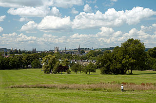
South Park is a park on Headington Hill in east Oxford, England. It is the largest park within Oxford city limits. A good view of the city centre with its historic spires and towers of Oxford University can be obtained at the park's highest point, a favourite location for photographers.

Warneford Meadow is an area of 20 acres (8.1 ha) of natural grassland immediately south-east of the Warneford Hospital, in Headington, east Oxford, England. The Warneford Meadow is a wild space within urban Oxford. The area has been used by local residents as a public space for recreation for over 50 years.
The Warneford Hospital is a hospital providing mental health services at Headington in east Oxford, England. It is managed by the Oxford Health NHS Foundation Trust.
Pullens Lane is in Headington, east Oxford, England. It is located at the top of Headington Hill, leading north off Headington Road to Jack Straw's Lane and Harberton Mead. The cul-de-sac Pullens Field leads off west from Pullens Lane.
Headington Hill Park is a park on Headington Hill in the east of Oxford, England.
St Clement's Church is an evangelical Church of England parish church situated just to the east of central Oxford, England.
Morrell's Brewing Company, also known as the Lion Brewery, was the only major brewery in Oxford, England. It operated between 1782 and 1998.

Old Road is a long street in Headington, east Oxford, England, extending into Oxfordshire as a road east of Oxford, to Littleworth near Wheatley. It is part of the main old road between Oxford and London until the late 18th century, passing over Shotover Hill. Nowadays it crosses the Oxford Ring Road (A4142) with a bridge.

The Oxford Spanish Civil War memorial is a monument in Oxford dedicated to the 31 known local residents who fought in the Spanish Civil War (1936–1939) against Nationalist forces. Erected and unveiled in 2017, the memorial is located close to South Park, near the base of Headington Hill by the junction of Headington Road and Morrell Avenue. The memorial is dedicated to all the volunteers with links to Oxfordshire who supported the Republicans and inscribed onto the front are the names of the six volunteers in the International Brigades who were killed during the war.


