
Miramichi ( ) is the largest city in northern New Brunswick, Canada. It is situated at the mouth of the Miramichi River where it enters Miramichi Bay. The Miramichi Valley is the second longest valley in New Brunswick, after the Saint John River Valley.

The Miramichi River is a river located in the east-central part of New Brunswick, Canada. The river drains into Miramichi Bay in the Gulf of St. Lawrence. The name may have been derived from the Montagnais words "Maissimeu Assi", and it is today the namesake of the Miramichi Herald at the Canadian Heraldic Authority.
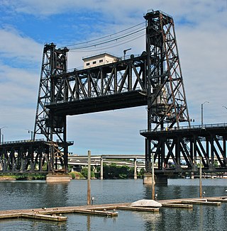
The Steel Bridge is a through truss, double-deck vertical-lift bridge across the Willamette River in Portland, Oregon, United States, opened in 1912. Its lower deck carries railroad and bicycle/pedestrian traffic, while the upper deck carries road traffic, and light rail (MAX), making the bridge one of the most multimodal in the world. It is the only double-deck bridge with independent lifts in the world and the second oldest vertical-lift bridge in North America, after the nearby Hawthorne Bridge. The bridge links the Rose Quarter and Lloyd District in the east to Old Town Chinatown neighborhood in the west.
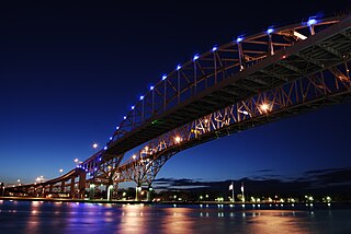
The Blue Water Bridge is a twin-span international bridge across the St. Clair River that links Port Huron, Michigan, United States, and Point Edward, Ontario, Canada. The Blue Water Bridge connects Highway 402 in Ontario with both Interstate 69 (I-69) and Interstate 94 (I-94) in Michigan.

The Maurice J. Tobin Memorial Bridge is a cantilever truss bridge that spans more than two miles (3.2 km) from Boston to Chelsea over the Mystic River in Massachusetts. The bridge is the largest in New England. It is operated by the Massachusetts Department of Transportation and carries U.S. Route 1. It was built between 1948 and 1950 and opened to traffic on February 2, 1950, replacing the former Chelsea Bridge. The 36-foot (11 m)-wide roadway has three lanes of traffic on each of the two levels with northbound traffic on the lower level and southbound traffic on the upper level.

Newcastle is an urban neighbourhood in the city of Miramichi, New Brunswick, Canada.

The Northwest Miramichi River or Elmunokun is a river in New Brunswick, Canada. The Mi'kmaq referred to the river as Elmunokun, possibly meaning "a beaver hole" in reference to a deep pool in the river, just below the mouth of the Big Sevogle River, its second largest tributary, after the Little Southwest Miramichi.

The Princess Margaret Bridge, sometimes called the Princess Margaret Rose Bridge or shortened to just PMB, is a two-lane highway bridge crossing the Saint John River at Fredericton, New Brunswick, Canada. It is named after Queen Elizabeth II's sister Princess Margaret, Countess of Snowdon.
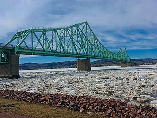
The J. C. Van Horne Bridge is a Canadian steel through truss/steel deck truss bridge crossing the Restigouche River between Campbellton, New Brunswick, and Pointe-à-la-Croix, Quebec.
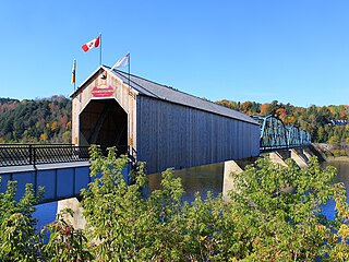
The Florenceville Bridge is a wooden covered bridge combined with a steel trusses which crosses the Saint John River at Florenceville, New Brunswick, Canada. Built in 1907, the 46.9 metre bridge has one wooden Howe truss span, four steel through trusses and one plate girder span. The bridge evolved from a five span uncovered Burr Truss bridge built in 1885. One Burr span was converted to a covered Howe truss and in 1907 the others were converted to steel thru trusses.
The Miramichi Bridge is a bridge crossing the Miramichi River in the City of Miramichi, New Brunswick, Canada.Locals call it the "new" Bridge. The Miramichi. bridge is not to be confused with the Centennial Bridge located in Miramichi.

The Hillsborough River Bridge is a bridge crossing the Hillsborough River estuary between Charlottetown and Stratford in Queens County, Prince Edward Island. The current road bridge, built in 1962, replaced a 1905 rail bridge crossing the same span which was known by the same name.

The River Don Navigation was the result of early efforts to make the River Don in South Yorkshire, England, navigable between Fishlake and Sheffield. The Dutch engineer Cornelius Vermuyden had re-routed the mouth of the river in 1626, to improve drainage, and the new works included provision for navigation, but the scheme did not solve the problem of flooding, and the Dutch River was cut in 1635 to link the new channel to Goole. The first Act of Parliament to improve navigation on the river was obtained in 1726, by a group of Cutlers based in Sheffield; the Corporation of Doncaster obtained an Act in the following year for improvements to the lower river. Locks and lock cuts were built and by 1751 the river was navigable to Tinsley.

The Fredericton Railway Bridge is a former railway bridge in Fredericton, New Brunswick, Canada now used to carry pedestrians and cyclists.

The Oliver Bridge is a bridge across the Saint Louis River. It was constructed in 1910 as a railway bridge by the Interstate Transfer Railway Company, a Wisconsin corporation, under special federal authorization from the 60th United States Congress. A lower deck carrying road traffic was constructed in 1917 It connects the Gary – New Duluth neighborhood in Duluth, Minnesota with the village of Oliver, Wisconsin. The bridge is 1,889 feet (576 m) long and is principally of steel truss construction.

The Court Street Bridge, also known as the Harold J. Dillard Memorial Bridge, is a vehicular movable bridge crossing the Hackensack River between Hackensack and Bogota in Bergen County, New Jersey, which owns it. Located 16.2 miles (26.1 km) from the river mouth at Newark Bay, the swing bridge, which opened in 1908 and underwent major rehabilitation in 2010–2012, is the most-upstream bridge on the river required by federal regulations to open on request.
Gregory Avenue Bridge, earlier known as the Main Avenue Bridge, is road bridge over the Passaic River in northeastern New Jersey, United States. It is the 7th bridge to be built at the river crossing. Originally built in 1905 as a moveable bridge, it has been in a fixed closed position since 1985. A four lane road carries traffic between Passaic & Wallington at the Passaic and Bergen county line.

Midtown Bridge, also known as the Salem Street Bridge and William C. Ryan Memorial Bridge, crosses over the Hackensack River between Hackensack and Bogota, in Bergen County, New Jersey, United States. The through truss bridge was originally a swing bridge built in 1900 for trolleys. It became a road bridge in 1940 and its swing span was fixed in 1984. It was closed in 2017 and slated for replacement; the rebuilt bridge reopened in April 2018.

Old Cobram-Barooga Bridge is a heritage-listed former road bridge and now footbridge over the Murray River at Barooga-Cobram Road, Barooga, New South Wales, Australia. The bridge links Barooga with Cobram, its sister town in Victoria. It was designed by Ernest de Burgh (engineer) and the New South Wales Department of Public Works and built from 1900 to 1902. It is also known as RMS Bridge No 3247. It is owned by Transport for NSW. It was added to the New South Wales State Heritage Register on 1 April 2016.

The Murray River road bridge is a heritage-listed road bridge that carries Swan Hill Road across the Murray River, on the border between New South Wales and Victoria, Australia. The bridge connects Murray Downs in New South Wales with McCallum Street in Swan Hill, Victoria. The bridge was built in 1896 and is owned by Transport for NSW. The bridge is also called the Swan Hill Bridge and the Swan Hill-Murray River Road Bridge. It was added to the New South Wales State Heritage Register on 20 June 2000.


