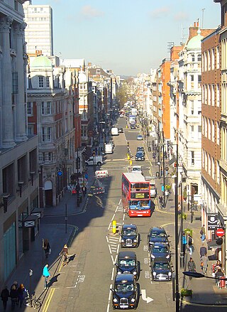
Great Portland Street is a road in the West End of London which links Oxford Street with the A501 Marylebone Road. A commercial street, it divides Fitzrovia, to the east, from Marylebone to the west. It delineates areas with contrasting identities, the west at strongest in grandiose Portland Place and Harley Street, the east at strongest in artists' and independent businesses of Fitzrovia.

Schomberg House at 80–82 Pall Mall is a prominent house on the south side of Pall Mall in central London which has a colourful history. Only the street facade survives today. It was built for the 3rd Duke of Schomberg, a Huguenot general in the service of the British Crown. It was adapted from Portland House, which in turn had been created by the Countess of Portland by converting two houses into a single residence. Work began in 1694, the year after the duke inherited his title.

Arthur Beresford Pite was a British architect known for creating Edwardian buildings in Baroque Revival, Byzantine Revival and Greek Revival styles.

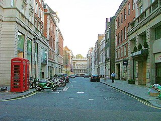
Eastcastle Street is a street in the City of Westminster. It runs from Newman Street in the east to Great Titchfield Street in the west. It is crossed by Berners Street and Wells Street. Winsley Street runs from its south side. Berners Mews joins it on the north side and Berners Place on the south.
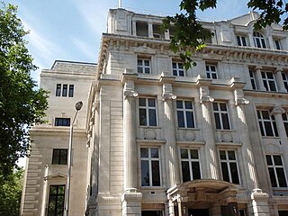
30 Euston Square is a building located at the corner of Euston Road and Melton Street, London NW1. Originally built as the headquarters of an assurance company, it has since been converted to form the headquarters of the Royal College of General Practitioners (RCGP). Its architectural style is Greek Revival. The first phase, built in 1906–08, was designed by Arthur Beresford Pite, and the 1932 extension is by W. H. Gunton.

Hill Street is a street in Mayfair, London, which runs south-west, then west, from Berkeley Square to Deanery Street, a short approach way from Park Lane. It was developed from farmland in the 18th century. Travelling one block to the east and south sees a fall of about three metres, whereas in the other direction the land rises gradually across six main blocks to beyond the north of Marble Arch. Hill Street's homes gained fashionable status from the outset: grand townhouses seeing use, at first, as seasonal lettings (rentals) and/or longer-term London homes of nobility — later, of other wealthy capitalists as much. Twenty-two, approximately half of its town houses, are listed. Along its course, only Audley Square House departs from townhouse-sized frontage, yet this shares in the street's predominant form of domestic architecture, Georgian neo-classical. Hill Street's public house is the oldest surviving one in Mayfair.
Sackville Street is a street in central London which today is mainly composed of offices and the rears of retail premises, but once was the home to several important medical figures.

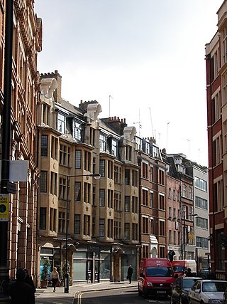
Beak Street is a street in Soho, London, that runs roughly east–west between Regent Street and Lexington Street.
The Sun and 13 Cantons is a Grade II listed public house at 20 Great Pulteney Street, Soho, London W1.
Hinde Street is a street in the Marylebone district of the City of Westminster, London, that contains the Hinde Street Methodist Church and was home to the novelist Rose Macaulay until her death.

Riding House Street is a street in central London in the City of Westminster.
Newman Street is a street in the City of Westminster. It runs from the junction of Mortimer Street, Cleveland Street, and Goodge Street in the north to Oxford Street in the south and is joined on its western side by Eastcastle Street.

The George is a grade II listed public house on the corner of Mortimer Street and Great Portland Street in the City of Westminster, London.
42–44 Mortimer Street is an architecturally notable former youth hostel in Mortimer Street, in the City of Westminster, London. It was designed by Arthur Beresford Pite and is grade II listed with Historic England. A London County Council plaque on the building records that the sculptor Joseph Nollekens once lived on a house on the site.

The London Edition is a historic luxury boutique hotel, formerly known as the Berners Hotel, located in Berners Street in the City of Westminster, London.
Manchester is a city in Northwest England. The M1 postcode area of the city includes part of the city centre, in particular the Northern Quarter, the area known as Chinatown, and part of the district of Chorlton-on-Medlock. The postcode area contains 194 listed buildings that are recorded in the National Heritage List for England. Of these, 14 are listed at Grade II*, the middle of the three grades, and the others are at Grade II, the lowest grade.

George Dennis Martin, F.S.I. was an English architect based in London.

79 Mount Street is a house in Mount Street, Mayfair, London W1.

Margaret Street is a street that straddles the Marylebone and Fitzrovia areas of the City of Westminster in the West End of London, running from Cavendish Square to Wells Street via Regent Street (A4201), Great Portland Street, and Great Titchfield Street. It is north of and parallel to the major shopping street, Oxford Street. John Prince's Street runs between Margaret Street and Oxford Street.

Mansfield Street is a street in the Marylebone district of central London.

