
Croxteth Hall is a country estate and Grade II* listed building in the West Derby suburb of Liverpool, England. It is the former country estate and ancestral home of the Molyneux family, the Earls of Sefton. After the death of the seventh and last Earl in 1972, the estate passed to Liverpool City Council, which now manages the remainder of the estate following the sale of approximately half of the grounds. The remaining grounds, Croxteth Park, were at one time a hunting chase of the Molyneux family and are now open to the public.

Bamford is a village in the Peak District, Derbyshire, England, close to the River Derwent. To the north-east is Bamford Edge, and to the north-west the Ladybower, Derwent and Howden Reservoirs. At the 2011 census, it had a population of 1,241.

Beighton —which includes the districts of Beighton, Hackenthorpe, Owlthorpe, and Sothall—is one of the 28 electoral wards in City of Sheffield, England. It is located in the eastern part of the city, on the border with Rotherham and covers an area of 5.7 km2. The population of this ward in 2011 was 17,939 people in 7,538 households.

Sheffield Attercliffe was a parliamentary constituency in the City of Sheffield. It was created at the 1885 general election and abolished at the 2010 general election, when it was replaced by a new Sheffield South East constituency.

Bishops' House is a half-timbered house in the Norton Lees district of the City of Sheffield, England. It was built c. 1500 and is located on the southern tip of Meersbrook Park. It is one of the three surviving timber-framed houses in the city.

Mosborough is an electoral ward of the City of Sheffield, England, in the eastern part of the city, on the border with North East Derbyshire District. The population in 2011 was 17,097. It is one of the wards that make up the Sheffield South East constituency.

Cottingham is a large village and civil parish in the East Riding of Yorkshire, England. It lies 4 miles (6 km) north-west of the centre of Kingston upon Hull, and 6 miles (10 km) south-east of Beverley on the eastern edge of the Yorkshire Wolds. It has two main shopping streets, Hallgate and King Street, which cross each other near the Church of Saint Mary the Virgin, and a market square called Market Green. Cottingham had a population of 17,164 residents in 2011, making it larger by area and population than many towns. As a result, it is one of the villages claiming to be the largest village in England.

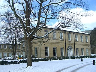
The Sir Frederick Mappin Building, or more familiarly the Mappin Building, is a Grade II listed building fronting onto Mappin Street, Sheffield, England, part of the University of Sheffield. The building and street are named after Sir Frederick Mappin (1821–1910), the so-called Father of Sheffield University.

Carbrook Hall is a historic house in Sheffield, England. Located in the Carbrook district of the city, the original building was owned by the Blunt family from 1176. This was rebuilt in 1462, and was bought by Thomas Bright in the late 16th century. His descendant, John Bright, was an active Parliamentarian during the English Civil War, and the building was used as a Roundhead meeting place during the siege of Sheffield Castle. The Bright family continued to play a prominent role in Sheffield, however, by the end of the eighteenth century the gentry line had died out. Writing in 1819 Joseph Hunter, a minister and antiquarian from Sheffield wrote "the hall at Carbrook...has been deserted by its owners for more than a century but still retains traces of its former consequence".
Broom Hall is a historic house in the City of Sheffield, England that gives its name to the surrounding Broomhall district of the city. The earliest part of the house is timber-framed; it has been tree-ring dated to c1498, and was built by the de Wickersley family, whose ancestral home was at Wickersley. The de Wickersley family descended from Richard FitzTurgis, who co-founded Roche Abbey in South Yorkshire. The de Wickersley family later dropped their Norman name (FitzTurgis) in favour of the village they controlled.

Westfield School, is a mixed secondary school located in Sheffield, South Yorkshire, England. On 1 December 2018 it joined Chorus Education Trust, a local multi-academy trust founded by Silverdale School in Sheffield. The school was a specialist Sports College but removed this title from the name in June 2013. It serves an area on the south east edge of Sheffield where many people now work in service industries and where levels of prosperity range from above to below average.

Shire Brook is a small stream in the south eastern part of the City of Sheffield in South Yorkshire, England. It rises in the suburb of Gleadless Townend and flows in a general easterly direction for 4 miles (6.5 km) to its confluence with the River Rother between Beighton and Woodhouse Mill. In the past the brook has been both the border of Yorkshire and Derbyshire and between the sees of Canterbury and York. The course of the stream has been influenced by human intervention in the 20th century with the brook being diverted underground and flowing through culverts on three occasions as it traverses locations which were formerly landfill sites and extensive railway sidings.

Whitley Hall is a 16th-century mansion which since 1969 has been converted into a restaurant and then a hotel. It is situated in the northern rural district of the City of Sheffield in South Yorkshire, England. The small hamlet of Whitley lies in the countryside between the suburbs of Grenoside, Chapeltown and Ecclesfield some 7.5 km (4.7 mi) north of the city centre. The hall is a Grade II* listed building.

Hallfield House is a Grade II listed building situated in Bradfield Dale, 1.7 miles (2.74 km) west of the village of Low Bradfield, near Sheffield in England.

Sheffield South East is a constituency represented in the House of Commons of the UK Parliament since its 2010 creation by Clive Betts, a member of the Labour Party.

Revell Grange is a Grade II listed English country house situated on Bingley Lane in the suburb of Stannington overlooking the Rivelin valley within the City of Sheffield, England. The house played an important role as a focal point of early Catholicism within the city and still houses a private chapel to this day.

Mosborough is a village in the City of Sheffield in South Yorkshire, England. Historically part of Derbyshire, the village was named after The Moss river which flows through the village. During the late 19th century and 20th century, the village was noted for its steelmaking, with Hutton & Co. Sickle works being based at nearby Ridgeway. The village expanded due to developments in nearby Owlthorpe, Westfields and Waterthorpe. Mosborough, which was a township at the time, was transferred from Derbyshire to the West Riding of Yorkshire as part of Sheffield.

Teversal Manor is a small Grade II listed 17th-century country house in Teversal, Nottinghamshire, some 5 km west of Mansfield.
Paper Hall is a Grade II* listed building in Bradford, West Yorkshire, England, noted for being the oldest domestic building in the city centre and for housing the city's first spinning machines. Its then owner James Garnett is credited with bringing the industrial revolution to Bradford, which became one of the manufacturing centres of Britain in the 19th century.

Plumbley is a hamlet in the City of Sheffield borough, within the county of South Yorkshire in England.
