Mossley Hall

Last updated

Mossley Hall
Mossley Old Town Hall - geograph.org.uk - 1563840 (cropped).jpg
The building in 2009
LocationStamford Road, Mossley
Coordinates 53°30′55″N2°02′33″W / 53.5152°N 2.0426°W / 53.5152; -2.0426
Built1864
ArchitectWilliam Williamson
Architectural style(s) Italianate style
Listed Building – Grade II
Official nameFormer Mossley Town Hall
Designated22 November 1966
Reference no.1068044
Greater Manchester UK location map 2.svg
Red pog.svg
Shown in Greater Manchester

Mossley Hall, formerly known as Mossley Town Hall, is a former municipal building in Stamford Road, Mossley, a town in Greater Manchester in England. The building, which served as the offices and meeting place of Mossley Borough Council, is a grade II listed building. [1]

Contents

History

The building was commissioned as a private house by a local cotton mill proprietor, George Mayall and his wife, Esther Mayall. The Mayall family owned Bottoms' Mill on Mill Street on the east side of the railway and had installed a large number of new cotton-spinning machines there. [2] The site they selected for their house was on the west side of Stamford Road, on the site of an old quarry. [3]

Work began on the new building in 1861. It was designed by William Williamson in the Italianate style, built by Edward Marland in ashlar stone at a cost of over £60,000 and was completed in 1864. [4] The design involved an asymmetric main frontage of eight bays facing Stamford Road. Esther died before the building was completed, and it was instead occupied by their son, Edmund Lees Mayall, and his wife, Martha. Martha lived in the house after Edmund died in 1877. The house had two lodges and was known as Whitehall. [5]

In 1885, the local area was incorporated as a municipal borough and the Mossley local board of health was succeeded by Mossley Borough Council. [6] [7] In 1891, the new council purchased the building for just £4,000. [8] It was refurbished and officially opened by the mayor, Joseph Fearns Lawton, as Mossley Town Hall on 7 May 1892. [2]

A serious accident occurred in Mossley on 20 October 1911, when a tram ran away down Stamford Road, derailed and crashed onto the railway at Mossley railway station, killing the guard and four passengers and seriously injuring four passengers. [9] The ensuing inquest was held in the town hall. [10]

During the First World War the building was used as a venue to hear appeals against conscription. It was also the meeting place of the Food Control Committee, which organised food rationing in the area. [8] A memorial, in the form of a female figure sculpted in white marble standing on a pedestal, which was intended to commemorate the lives of local service personnel who had died in the war, was unveiled in front of the town hall by the mayor, John Platt, on 9 October 1920. [11] [12] [13]

The building was grade II listed in 1966. [1] It continued to serve as the headquarters of the borough council for much of the 20th century, [14] but ceased to be the local seat of government when the enlarged Tameside Metropolitan Borough Council was formed in 1974. [15] The building subsequently became disused and, after being declared surplus to requirements by the council, it was eventually sold in 1986. [8] Many of the lavish interior fittings were removed in 1999, [16] when it was acquired for residential use by Philip and Carol Wilson. They initiated an extensive refurbishment programme, which was completed in 2015. [17]

Architecture

The two-storey building is constructed of stone, with a slate roof. The third bay on the left, which is projected forward, features a tri-partite window on the ground floor, a pedimented sash window on the first floor and a gable above. The second bay on the left features a porch, which is also projected forward and formed by piers supporting arches with keystones. The porch is highly ornamented with various carved panels, a balustrade above, and urns on the corners. [1] [18]

See also

Related Research Articles

<span class="mw-page-title-main">Tameside</span> Borough in Greater Manchester, England

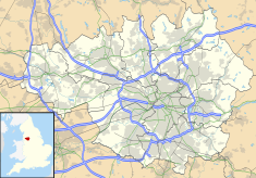
Tameside is a metropolitan borough of Greater Manchester, England, named after the River Tame, which flows through it, and includes the towns of Ashton-under-Lyne, Audenshaw, Denton, Droylsden, Dukinfield, Hyde, Mossley and Stalybridge. Tameside is bordered by the metropolitan boroughs of Stockport to the south, Oldham to the north and northeast, Manchester to the west, and to the east by the Borough of High Peak in Derbyshire. As of 2021, the population of Tameside was 231,199, making it the 8th-most populous borough of Greater Manchester by population.

<span class="mw-page-title-main">Stalybridge</span> Town in Greater Manchester, England

Stalybridge is a town in Tameside, Greater Manchester, England, with a population of 23,731 at the 2011 Census.

<span class="mw-page-title-main">Mottram in Longdendale</span> Human settlement in England

Mottram in Longdendale is a village in Tameside, Greater Manchester, England. At the 2011 census, the population for the ward of Longdendale, which includes Mottram and the surrounding area, was 9,950.

<span class="mw-page-title-main">Denton, Greater Manchester</span> Town in Greater Manchester, England

Denton is a town in Tameside, Greater Manchester, England, five miles (8 km) east of Manchester city centre. Historically part of Lancashire, it had a population of 36,591 at the 2011 Census.

<span class="mw-page-title-main">Trafford</span> Borough in Greater Manchester, England

Trafford is a metropolitan borough of Greater Manchester, England, with an estimated population of 235,546 in 2021. It covers 106 square kilometres (41 sq mi) and includes the area of Old Trafford and the towns of Altrincham, Stretford, Urmston, Partington and Sale. The borough was formed in 1974 as a merger of six former districts and part of a seventh. The River Mersey flows through the borough, separating North Trafford from South Trafford, and the historic counties of Lancashire and Cheshire. Trafford is the seventh-most populous district in Greater Manchester.

<span class="mw-page-title-main">Stockport</span> Town in Greater Manchester, England

Stockport is an industrial town in Greater Manchester, England, 7 miles (11 km) south-east of Manchester, 9 miles (14 km) south-west of Ashton-under-Lyne and 12 miles (19 km) north of Macclesfield. The River Goyt and Tame merge to create the River Mersey here. It is the main settlement of the wider Metropolitan Borough of Stockport.

<span class="mw-page-title-main">Ashton-under-Lyne</span> Market town in Greater Manchester, England

Ashton-under-Lyne is a market town in Tameside, Greater Manchester, England. The population was 48,604 at the 2021 census. Historically in Lancashire, it is on the north bank of the River Tame, in the foothills of the Pennines, 6 miles (9.7 km) east of Manchester.

<span class="mw-page-title-main">Dukinfield</span> Town in Greater Manchester, England

Dukinfield is a town in Tameside, Greater Manchester, England, on the south bank of the River Tame opposite Ashton-under-Lyne, 6.3 miles (10.1 km) east of Manchester. At the 2011 Census, it had a population of 19,306.

<span class="mw-page-title-main">Hyde, Greater Manchester</span> Town in Tameside, Greater Manchester, England

Hyde is a town in Tameside, Greater Manchester, England, which had a population of 35,890 in 2021.

<span class="mw-page-title-main">Audenshaw</span> Town in Greater Manchester, England

Audenshaw is a town in Tameside, Greater Manchester, England, 4.9 miles (7.9 km) east of Manchester. Historically part of Lancashire, in 2011 it had a population of 11,419.

<span class="mw-page-title-main">Mossley</span> Town in Tameside, Greater Manchester, England

Mossley (/ˈmɒzli/) is a town and civil parish in Tameside, Greater Manchester, England. It is located in the upper Tame Valley and the foothills of the Pennines, 3 miles (4.8 km) south-east of Oldham and 9 miles (14.5 km) east of Manchester.

<span class="mw-page-title-main">Droylsden</span> Town in Greater Manchester

Droylsden is a town in Tameside, Greater Manchester, England, 4.1 miles (6.6 km) east of Manchester city centre and 2.2 miles (3.5 km) west of Ashton-under-Lyne, with a population at the 2011 Census of 22,689.

<span class="mw-page-title-main">Middleton, Greater Manchester</span> Town in Greater Manchester, England

Middleton is a town in the Metropolitan Borough of Rochdale, Greater Manchester, England, on the River Irk 5 miles (8.0 km) southwest of Rochdale and 5 miles (8.0 km) northeast of Manchester. Middleton had a population of 42,972 at the 2011 Census. It lies on the northern edge of Manchester, with Blackley to the south and Moston to the south east.

<span class="mw-page-title-main">Stayley Hall</span> Building in Greater Manchester, England

Stayley Hall, also known as Staley Hall, is a Grade II* Listed Building in Stalybridge, Greater Manchester. The structure dates back to at least the early 15th century. The first records of the de Stavelegh family as Lords of the Manor of Staley date from the early 13th century. Stayley Hall was their residence

<span class="mw-page-title-main">Grade II* listed buildings in Greater Manchester</span>

There are 236 Grade II* listed buildings in Greater Manchester, England. In the United Kingdom, the term listed building refers to a building or other structure officially designated as being of special architectural, historical or cultural significance; Grade II* structures are those considered to be "particularly significant buildings of more than local interest". In England, the authority for listing under the Planning Act 1990 rests with English Heritage, a non-departmental public body sponsored by the Department for Culture, Media and Sport.

<span class="mw-page-title-main">Grade I listed buildings in Greater Manchester</span>

There are 48 Grade I listed buildings in Greater Manchester, England. In the United Kingdom, the term listed building refers to a building or other structure officially designated as being of special architectural, historical or cultural significance; Grade I structures are those considered to be "buildings of exceptional interest". In England, the authority for listing under the Planning Act 1990 rests with Historic England, a non-departmental public body sponsored by the Department for Culture, Media and Sport.

Mossley is a civil parish in Tameside, Greater Manchester, England, and includes the small town of Mossley and the surrounding countryside. The parish contains 50 listed buildings that are recorded in the National Heritage List for England. All the listed buildings are designated at Grade II, the lowest of the three grades, which is applied to "buildings of national importance and special interest".

<span class="mw-page-title-main">Hyde Town Hall</span> Municipal building in Hyde, Greater Manchester, England

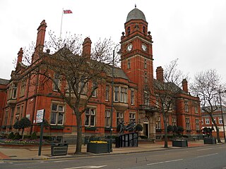
Hyde Town Hall is a municipal building in the Market Street, Hyde, Greater Manchester, England. The town hall, which was the headquarters of Hyde Borough Council, is a grade II listed building.

<span class="mw-page-title-main">Dukinfield Town Hall</span> Municipal building in Dukinfield, Greater Manchester, England

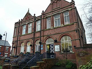
Dukinfield Town Hall is a municipal building in King Street, Dukinfield, Greater Manchester, England. The town hall, which was the headquarters of Dukinfield Borough Council, is a grade II listed building.

<span class="mw-page-title-main">Stalybridge Town Hall</span> Municipal building in Stalybridge, Greater Manchester, England

Stalybridge Town Hall was a municipal building in Stamford Street, Stalybridge, Greater Manchester, England. The building, which was the meeting place of Stalybridge Borough Council, was a Grade II listed building.

References

  1. 1 2 3 Historic England. "Former Mossley Town Hall (1068044)". National Heritage List for England . Retrieved 25 February 2024.
  2. 1 2 "Mossley". Tameside Metropolitan Borough Council. Retrieved 25 February 2024.
  3. "Ordnance Survey Map". 1860. Retrieved 25 February 2024.
  4. "A Combined Record of St George's Church monumental inscriptions and register of graves" (PDF). St George's, Mossley. p. 66. Retrieved 25 February 2024.
  5. "Shirley Visits The Big Houses". Mossley Civic Society. Retrieved 25 February 2024.
  6. Holt, Alfred (1974) [1926]. The Story of Mossley; Ancient and Modern. Mossley Civic Society. p. 9.
  7. Nevell, Michael (1993). "Chapter 2: An Industrial Society". Tameside 1700–1930. A History and Archaeology of Tameside. Tameside Metropolitan Borough Council. p. 11. ISBN   1-871324-08-4. OCLC   53181546.
  8. 1 2 3 "Mossley WW1 blue plaque trail" (PDF). Tameside History Forum. Retrieved 24 February 2024.
  9. "Tramcar accident near Manchester". The Times. No. 39722. London. 21 October 1911. col D, p. 8.
  10. The Mossley Accident. Vol. 30. Tramway and Railway World. 1911. p. 392.
  11. "Mossley Memorial". Memorials Online. Retrieved 24 February 2024.
  12. "Mossley". Imperial War Museum. Retrieved 24 February 2024.
  13. "Mossley War Memorial". Tameside Metropolitan Borough Council. Retrieved 25 February 2024.
  14. "No. 45941". The London Gazette . 30 March 1973. p. 4217.
  15. Local Government Act 1972. 1972 c.70. The Stationery Office Ltd. 1997. ISBN   0-10-547072-4.
  16. Raven, Joyce; Sheppard, Mark (2011). Tameside Through Time. Amberley Publishing. ISBN   978-1445631288.
  17. "A novel way to look at Mossley's history". Quest Media Network. Retrieved 25 February 2024.
  18. Hartwell, Clare; Hyde, Matthew; Pevsner, Nikolaus (2004). Lancashire: Manchester and the South-East. The Buildings of England. New Haven and London: Yale University Press. p. 526. ISBN   978-0300105834.