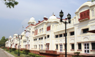
Patiala is a city in southeastern Punjab, northwestern India. It is the fourth largest city in the state and is the administrative capital of Patiala district. Patiala is located around the Qila Mubarak constructed by a chieftain Ala Singh, who founded the royal dynasty of Patiala State in 1763, and after whom the city is named.

Karol Bagh is a neighborhood in Central District of Delhi, India. It is a mixed residential and commercial neighborhood known for shopping streets, such as the Ghaffar Market and Ajmal Khan Road.

Mehrauli is a neighbourhood in South Delhi, Delhi, India. It represents a constituency in the legislative assembly of Delhi. The area is close to Gurugram and next to Vasant Kunj.
Mayur Vihar is an upmarket residential area is located on periphery of Delhi in East Delhi close to the city's Noida-Delhi border, situated just across the Yamuna River, and is divided into three distinct phases. As the name suggests, it has been the dwelling (vihar) of peacocks (mayur). Even today, the area has a closed sanctuary dedicated to the conservation of peacocks.
Kaithal is a city and municipal council in the Kaithal district of the Indian state of Haryana. Kaithal was previously a part of Karnal district and later, Kurukshetra district until 1 November 1989, when it became the headquarters of the Kaithal. It shares a border with the Patiala district of state Punjab and the Kurukshetra, Jind and Karnal districts of Haryana. Kaithal district is situated in the North-West of the Haryana state. Its North-West boundaries, which include Guhla-Cheeka are attached to Punjab.
Ramakrishna Puram popularly known as R.K. Puram, is a residential colony in Delhi. Named after the saint Sri Ramakrishna, it houses many high-profile corporate houses.

Gole Market is a neighborhood in the heart of New Delhi, India built within a traffic roundabout by Edwin Lutyens in 1921. It is one of New Delhi's oldest surviving colonial markets and is considered an architecturally significant structure. The dodecagonal market was built in the axis planned by Edwin Lutyens as part of New Delhi's layout. Peshwa Road, Ramakrishna Ashram Road, Shaheed Bhagat Singh Road, and Bhai Veer Singh Road are four radial roads leading from the market.

Anandpur Sahib, also referred simply as Anandpur, is a city in Rupnagar district (Ropar), on the edge of Shivalik Hills, in the Indian state of Punjab. Located near the Sutlej River, the city is one of the most sacred religious places in Sikhism, being the place where the last two Sikh Gurus, Guru Tegh Bahadur and Guru Gobind Singh, lived. It is also the place where Guru Gobind Singh founded the Khalsa Panth in 1699. The city is home to Takhat Sri Kesgarh Sahib, the third of the five Takhts in Sikhism.
New Friends Colony is a posh residential colony of South Delhi, India. It consists of A, B, C, D Blocks. It is situated near Uttar Pradesh border.
Rajouri Garden is a market and residential neighbourhood in South-West Delhi, India. The Main Market and Nehru Market are the key markets of the area. The population is largely Punjabi who migrated to Delhi, following the Partition of India, from Pakistan in 1947. The postal code of Rajouri Garden is 110027.

Majha is a region located in the central parts of the historical Punjab region, currently split between the republics of India and Pakistan. It extends north from the right banks of the river Beas, and reaches as far north as the river Jhelum. People of the Majha region are given the demonym "Mājhī" or "Majhail". Most inhabitants of the region speak the Majhi dialect, which is the basis of the standard register of the Punjabi language. The most populous city in the area is Lahore on the Pakistani side, and Amritsar on the Indian side of the border.

South Delhi is an administrative district of the National Capital Territory of Delhi in India with its headquarters in Saket. Administratively, the district is divided into three subdivisions, Saket, Hauz Khas, and Mehrauli. It is bounded by the Yamuna River to the east, the districts of New Delhi to the north, Faridabad District of Haryana state to the southeast, Gurgaon District of Haryana to the southwest, and South West Delhi to the west.
INA colony is a residential colony in South Delhi, New Delhi, India.
Malviya Nagar is a residential locality in South Delhi. Situated between Saket and Hauz Khas, its namesake is the freedom fighter Madan Mohan Malviya.
Dilshad Garden is a large housing colony located in East Delhi, which was primarily developed by Delhi Development Authority. The area Situated near Apsara border or Shahdara border within 0KM on fringe of Delhi which is one of the main border of Delhi which Separates Jurisdiction of NCT of Delhi and Uttar pradesh. Dilshad Garden falls under the both Shahdara and Seemapuri constituency of the legislative assembly. Thus, a part of Dilshad Garden falls under MLA of Seemapuri Vidhansabha Shri Rajender Pal Gautam and its other part falls under the MLA of Shahdara Vidhansabha Shri Ram Niwas Goyal.

Keshav Puram is a locality in the northwest district of Delhi, India. It was first developed by the Delhi Development Authority. The area has a lot of parks and the pollution levels are low. The number of people living there is also low.

Green Park is an upscale affluent neighborhood in South Delhi, India. The locality is divided into two parts i.e. Main and Extension. The neighbourhood registered a 4.4% growth in residential sales and was featured alongside Greater Kailash, Defence Colony, Vasant Vihar and Anand Niketan in the 2019 edition of Knight Frank's quarterly report on prime luxury residential properties in various megacities around the globe. Property rates have always been high in this colony due to the numerous facilities available. Builder floors and independent villas cost anywhere between INR 6–70 crores in this colony. Rental rates are also very high making this residential area among the most expensive pin codes of New Delhi.

Zafar Mahal, in Mehrauli village, in South Delhi, India, is considered as the last monumental structure built as a summer palace during the fading years of the Mughal era. The building has two components namely, the Mahal or the palace, which was built first by Akbar Shah II in the 18th century, and the entrance gate that was reconstructed in the 19th century by Bahadur Shah Zafar II, popularly known as "Zafar" meaning ‘Victory’. It has a forlorn history because Bahadur Shah Zafar, who wished to be buried in the precincts of the Zafar Mahal (palace) and the famous Dargah of Khwaja Qutubuddin Bakhtiar Kaki in Mehrauli, Delhi, was deported by the British to Rangoon, after the First War of Indian Independence in 1857, where he died of old age. The monument today is in a neglected and ruined state, locals play cricket and gamble freely inside the protected monument. The 18th-century palace has been all but subsumed by unauthorised constructions.

Madanpur Khadar is an urban village in South East district of Delhi. It is located on Delhi-UP Border and is named after Thakur Madan Singh Chauhan. The term Khadar is attached to the village’s name because it is situated on the banks of Yamuna river. It was declared as an urban village by the administrative authorities under Delhi Metropolitan Council in 1966.

