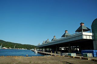
Kesennuma is a city in Miyagi Prefecture, Japan. As of 1 August 2020, the city had an estimated population of 59,803 and a population density of 190 inhabitants per square kilometre (490/sq mi) in 26,390 households. The total area of the city is 332.44 square kilometres (128.36 sq mi). Large sections of the city were destroyed by the 2011 Tōhoku earthquake and tsunami and major fires on March 11, 2011.
Miyagi District is a district located in past Mutsu Province and today's Miyagi Prefecture, Japan. The name of the prefecture was from this district.

Wakayanagi was a town located in Kurihara District, Miyagi Prefecture, Japan.

Toyosato was a town in the former Tome District, Miyagi Prefecture, Japan. It is now a part of the city of Tome.

Tome is a city located in Miyagi Prefecture, Japan. As of 30 April 2020, the city had an estimated population of 77,897 and a population density of 150 persons per km² in 27,298 households. The total area of the city is 536.12 square kilometres (207.00 sq mi). The area is noted for its rice production.
Shizugawa was a town located in Motoyoshi District, Miyagi Prefecture, Japan.

Motoyoshi is a rural district in Miyagi Prefecture, in the Tōhoku region of northern Japan.

Karakuwa was a town located in Motoyoshi District, in the extreme northeast of Miyagi Prefecture, bordering Kesennuma to the north-west and Rikuzentakata, part of Iwate Prefecture, to the north, and with Kesennuma Bay including Oshima island to the west, Hirota Bay to the north-east, and the Pacific Ocean to the south and east.
Utatsu was a town located in Motoyoshi District, Miyagi Prefecture, Japan.

The Kesennuma Line is a local railway line in Japan, operated by the East Japan Railway Company. It connected Maeyachi Station in the city of Ishinomaki, Miyagi to Kesennuma Station in the city of Kesennuma, Miyagi. The route links the north-eastern coast of Miyagi Prefecture, with the Ishinomaki Line available for transfer in the south, and the Ōfunato Line in the north.

Koganezawa Station was a railway station on the Kesennuma Line in the city of Kesennuma, Miyagi Prefecture, Japan, operated by East Japan Railway Company. The station was completely destroyed by the 2011 Tōhoku earthquake and tsunami and services have now been replaced by a provisional bus rapid transit line.

Motoyoshi Station was a railway station in the city of Kesennuma, Miyagi, Japan, operated by East Japan Railway Company until 2011. The station became a stop on the replacement bus rapid transit (BRT) line following the March 2011 Tōhoku earthquake and tsunami.

Rikuzen-Koizumi Station was a JR East railway station located in the city of Kesennuma, Miyagi Prefecture, Japan. The station was completely destroyed by the 2011 Tōhoku earthquake and tsunami and services have now been replaced by a provisional bus rapid transit line.

Kurauchi Station was a JR East railway station located in the city of Kesennuma, Miyagi Prefecture, Japan. Services have now been replaced by a provisional bus rapid transit line.

Rikuzen-Minato Station was a JR East railway station located in Minamisanriku, Miyagi Prefecture, Japan. The station was completely destroyed by the 2011 Tōhoku earthquake and tsunami, and services have now been replaced by a provisional bus rapid transit line.

Shizuhama Station was a JR East railway station located in Minamisanriku, Miyagi Prefecture, Japan. The blue-roofed station platform remained standing after the 2011 tsunami, however the adjacent railway bridge and track collapsed. Services have now been replaced by a provisional bus rapid transit line.
Minamisanriku is a town in Miyagi Prefecture, Japan. As of 1 May 2020, it had an estimated population of 12,516, and a population density of 77 persons per km² in 4504 households. The total area of the town is 163.40 square kilometres (63.09 sq mi). It is a resort town on a coastline of wooded islands and mountainous inlets, large sections of which suffered from damage due to the 2011 Tōhoku earthquake and tsunami.

Miyagi Prefecture is a prefecture of Japan located in the Tōhoku region of Honshu. Miyagi Prefecture has a population of 2,305,596 and has a geographic area of 7,282 km2 (2,812 sq mi). Miyagi Prefecture borders Iwate Prefecture to the north, Akita Prefecture to the northwest, Yamagata Prefecture to the west, and Fukushima Prefecture to the south.

Miyagi Prefecture 6th District was an electoral district for the Japanese House of Representatives. The district was established In 1994 as a single member district from most of Miyagi 2nd district.
