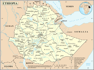
Ethiopia is located in the Horn of Africa. It is bordered by Eritrea to the north, Djibouti and Somalia to the east, Sudan and South Sudan to the west, and Kenya to the south. Ethiopia has a high central plateau that varies from 1,290 to 3,000 m above sea level, with the highest mountain reaching 4,533 m (14,872 ft).

South Africa occupies the southern tip of Africa, its coastline stretching more than 2,850 kilometres from the desert border with Namibia on the Atlantic (western) coast southwards around the tip of Africa and then northeast to the border with Mozambique on the Indian Ocean. The low-lying coastal zone is narrow for much of that distance, soon giving way to a mountainous escarpment that separates the coast from the high inland plateau. In some places, notably the province of KwaZulu-Natal in the east, a greater distance separates the coast from the escarpment. Although most of the country is classified as semi-arid, it has considerable variation in climate as well as topography. The total land area is 1,220,813 km2 (471,359 sq mi). It has the 23rd largest Exclusive Economic Zone of 1,535,538 km2 (592,875 sq mi).

The Gulf of Saint Lawrence is the outlet of the North American Great Lakes via the Saint Lawrence River into the Atlantic Ocean. The gulf is a semi-enclosed sea, covering an area of about 226,000 square kilometres (87,000 sq mi) and containing about 34,500 cubic kilometres (8,300 cu mi) of water, which results in an average depth of 152 metres (499 ft).

The Java Sea is an extensive shallow sea on the Sunda Shelf. It lies between the Indonesian islands of Borneo to the north, Java to the south, Sumatra to the west, and Sulawesi to the east. Karimata Strait to its northwest links it to the South China Sea. It is a part of the western Pacific Ocean.
U.S. Route 177 (US-177) is a spur of U.S. Route 77. It currently runs for 233 miles (375 km) from South Haven, Kansas at US-81 to Madill, Oklahoma at US-70. It passes through the states of Kansas and Oklahoma.
Hiri Motu, also known as Police Motu, Pidgin Motu, or just Hiri, is a language of Papua New Guinea.

The Maribyrnong River Trail is a shared use path for cyclists and pedestrians, which follows the Maribyrnong River through the north western suburbs of Melbourne, Victoria, Australia.

The Second Battle of the Sambre (which included the Second Battle of Guise and the Battle of Thiérache was part of the final European Allied offensives of World War I.
Orara River, a perennial stream of the Clarence River catchment, is located in the Northern Rivers district of New South Wales, Australia.
The Lerderderg Gorge is in Victoria, Australia. The Lerderderg River which emerges from the Great Dividing Range has cut a deep gorge as it winds toward the southern plains.

State Highway 2 runs north–south through eastern parts of the North Island of New Zealand from the outskirts of Auckland to Wellington. It runs via Tauranga in the Bay of Plenty, Gisborne, and Napier and Hastings in Hawke's Bay. It is the second-longest highway in the North Island, after State Highway 1, which runs the length of both of the country's main islands.
Reb River is a river of north-central Ethiopia which empties into Lake Tana at 12°2′N37°35′E. The river originates on the slopes of Mount Guna, and flows west through Kemekem woreda. It has no significant tributaries.

The path followed by the Oregon Trail, California Trail and Mormon Trail spans 400 miles (640 km) through the U.S. state of Wyoming. The trail entered from Nebraska on the eastern border of the state near the present day town of Torrington and exited on the western border near the towns of Cokeville and Afton. An estimated 350,000 to 400,000 settlers traveled on the trail through Wyoming between 1841 and 1868. All three trails follow the same path through most of the state. The Mormon Trail splits at Fort Bridger and enters Utah, while the Oregon and California Trails continue to Idaho.
US Highway 2 (US 2) is a component of the United States Numbered Highway System that connects Everett, Washington, to the Upper Peninsula (UP) of the US state of Michigan, with a separate segment that runs from Rouses Point, New York, to Houlton, Maine. In Michigan, the highway runs through the UP in two segments as a part of the state trunkline highway system, entering the state at Ironwood and ending at St. Ignace; in between, US 2 briefly traverses the state of Wisconsin. As one of the major transportation arteries in the UP, US 2 is a major conduit for traffic through the state and neighboring northern Midwest states. Two sections of the roadway are included as part of the Great Lakes Circle Tours, and other segments are listed as state-designated Pure Michigan Byways. There are several memorial highway designations and historic bridges along US 2 that date to the 1910s and 1920s. The highway runs through rural sections of the UP, passing through two national and two state forests in the process.
Dundee is a rural locality about 40 kilometres north of Glen Innes on the Northern Tablelands, New South Wales, Australia. It is situated on the New England Highway at the Severn River in Severn parish, Gough County, New South Wales. The elevation is 985 metres.
Mount Arowhana lies in the Raukumara Range in the northeast of New Zealand's North Island. Part of the backbone of the range, which forms part of a line of mountains extending across much of the North Island, 1440 metre (4724 ft) Arowhana is second only to Mount Hikurangi in terms of height within the Raukumara Range.
Maungahaumi is a mountain in the Raukumara Range in the northeast of New Zealand's North Island.

West Bourke was an electoral district of the Legislative Assembly in the Australian state of Victoria from 1856 to 1904.
Tōrere, previously known as Torere, is a small settlement in the Ōpōtiki District of the Bay of Plenty Region on New Zealand's North Island. It is the ancestral home of the Ngāitai people.
Motu is a rural community in the Gisborne District of New Zealand's North Island. It is located north of Matawai and State Highway 2. The community is centred around Motu River and Motu Falls.
