
Gustav Knepper Power Station was a coal-fired power station in Dortmund-Mengede, close to Castrop-Rauxel. Gustav Knepper Power Station was built on the area of former coal mine Gustav Knepper. Owner of the Gustav Knepper Power station first was the Gelsenkirchener Bergwerks AG, then the Bochumer Bergwerks AG.

Lublin Governorate, Polish: Gubernia lubelska) was an administrative unit (governorate) of the Congress Poland.
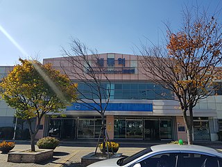
Seryu Station is a station on Line 1 of the Seoul Metropolitan Subway. It is in southern Suwon. Near Seryu Station lies Suwon Air Base, home to the ROKAF's 10th Fighter Wing. It is between Suwon station and Byeongjum station.

Ligota is a village in the administrative district of Gmina Trzebnica, within Trzebnica County, Lower Silesian Voivodeship, in south-western Poland, which, prior to 1945, was in Germany.
Gmina Głusk is a rural gmina in Lublin County, Lublin Voivodeship, in eastern Poland. It takes its name from Głusk – this was formerly a village, but in 1988 was incorporated into the city of Lublin, and is therefore no longer a part of the territory of Gmina Głusk, although it still serves as its administrative seat. The gmina lies to the south-east of the regional capital Lublin. It covers an area of 64 square kilometres (24.7 sq mi), and as of 2006 its total population is 7,372.
Bągart is a village in the administrative district of Gmina Płużnica, within Wąbrzeźno County, Kuyavian-Pomeranian Voivodeship, in north-central Poland.
Babice is a village in the administrative district of Gmina Obsza, within Biłgoraj County, Lublin Voivodeship, in eastern Poland. It lies approximately 5 kilometres (3 mi) north-west of Obsza, 27 km (17 mi) south-east of Biłgoraj, and 103 km (64 mi) south of the regional capital Lublin.
Marysin is a village in the administrative district of Gmina Rejowiec, within Chełm County, Lublin Voivodeship, in eastern Poland. It lies approximately 7 kilometres (4 mi) north-east of Rejowiec, 11 km (7 mi) south-west of Chełm, and 57 km (35 mi) east of the regional capital Lublin.
Podzamcze is a village in the administrative district of Gmina Bychawa, within Lublin County, Lublin Voivodeship, in eastern Poland. It lies approximately 2 kilometres (1 mi) north of Bychawa and 24 km (15 mi) south of the regional capital Lublin.
Konstancin is a village in the administrative district of Gmina Góra Świętej Małgorzaty, within Łęczyca County, Łódź Voivodeship, in central Poland. It lies approximately 12 kilometres (7 mi) north-east of Łęczyca and 36 km (22 mi) north of the regional capital Łódź.

Ruginoasa is a commune in Iași County, Romania. It is composed of four villages: Dumbrăvița, Rediu, Ruginoasa and Vascani.
Władysławów is a village in the administrative district of Gmina Pabianice, within Pabianice County, Łódź Voivodeship, in central Poland. It lies approximately 4 kilometres (2 mi) south-west of Pabianice and 20 km (12 mi) south-west of the regional capital Łódź.
Głuchów is a village in the administrative district of Gmina Konopnica, within Wieluń County, Łódź Voivodeship, in central Poland. It lies approximately 3 kilometres (2 mi) east of Konopnica, 25 km (16 mi) north-east of Wieluń, and 65 km (40 mi) south-west of the regional capital Łódź.
Antoniew is a village in the administrative district of Gmina Aleksandrów Łódzki, within Zgierz County, Łódź Voivodeship, in central Poland. It lies approximately 4 kilometres (2 mi) south-east of Aleksandrów Łódzki, 8 km (5 mi) south-west of Zgierz, and 9 km (6 mi) west of the regional capital Łódź.
Wojciechów is a village in the administrative district of Gmina Hańsk, within Włodawa County, Lublin Voivodeship, in eastern Poland. It lies approximately 7 kilometres (4 mi) south-west of Hańsk, 26 km (16 mi) south-west of Włodawa, and 56 km (35 mi) east of the regional capital Lublin.
Nowy Kazanów is a village in the administrative district of Gmina Końskie, within Końskie County, Świętokrzyskie Voivodeship, in south-central Poland. It lies approximately 6 kilometres (4 mi) west of Końskie and 39 km (24 mi) north-west of the regional capital Kielce.
Łubianki is a village in the administrative district of Gmina Sokołów Podlaski, within Sokołów County, Masovian Voivodeship, in east-central Poland. It lies approximately 3 kilometres (2 mi) north of Sokołów Podlaski and 88 km (55 mi) east of Warsaw.
Dzierzbin is a village in the administrative district of Gmina Mycielin, within Kalisz County, Greater Poland Voivodeship, in west-central Poland. It lies approximately 8 kilometres (5 mi) north-east of Korzeniew, 29 km (18 mi) north-east of Kalisz, and 102 km (63 mi) south-east of the regional capital Poznań.
Kłanino is a village in the administrative district of Gmina Krokowa, within Puck County, Pomeranian Voivodeship, in northern Poland. It lies approximately 6 kilometres (4 mi) east of Krokowa, 13 km (8 mi) north-west of Puck, and 51 km (32 mi) north-west of the regional capital Gdańsk.

Daliang Subdistrict is a sub-district in Shunde, Foshan, Guangdong, China, located to the east of Shunde City. It is the seat of the Shunde municipal government. It has a resident population of 310,000 with its total area of 80 square kilometres (31 sq mi).


