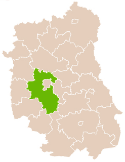
Lublin Governorate, Polish: Gubernia lubelska) was an administrative unit (governorate) of the Congress Poland.
Gmina Głusk is a rural gmina in Lublin County, Lublin Voivodeship, in eastern Poland. It takes its name from Głusk – this was formerly a village, but in 1988 was incorporated into the city of Lublin, and is therefore no longer a part of the territory of Gmina Głusk, although it still serves as its administrative seat. The gmina lies to the south-east of the regional capital Lublin. It covers an area of 64 square kilometres (24.7 sq mi), and as of 2006 its total population is 7,372.

The Archdiocese of Lublin is an archdiocese located in the city of Lublin in Poland.
Koszarówka is a village in the administrative district of Gmina Grajewo, within Grajewo County, Podlaskie Voivodeship, in north-eastern Poland.

Podzamcze is a village in the administrative district of Gmina Bychawa, within Lublin County, Lublin Voivodeship, in eastern Poland. It lies approximately 2 kilometres (1 mi) north of Bychawa and 24 km (15 mi) south of the regional capital Lublin.

Zdrapy is a village in the administrative district of Gmina Bychawa, within Lublin County, Lublin Voivodeship, in eastern Poland. It lies approximately 4 kilometres (2 mi) north of Bychawa and 23 km (14 mi) south of the regional capital Lublin.

Wojciechów is a settlement in the administrative district of Gmina Gomunice, within Radomsko County, Łódź Voivodeship, in central Poland. It lies approximately 13 kilometres (8 mi) north of Radomsko and 68 km (42 mi) south of the regional capital Łódź.

Zmyślona is a village in the administrative district of Gmina Mokrsko, within Wieluń County, Łódź Voivodeship, in central Poland. It lies approximately 3 kilometres (2 mi) south-east of Mokrsko, 10 km (6 mi) south-west of Wieluń, and 98 km (61 mi) south-west of the regional capital Łódź.

Barłogi is a village in the administrative district of Gmina Kurów, within Puławy County, Lublin Voivodeship, in eastern Poland. It lies approximately 4 kilometres (2 mi) north of Kurów, 17 km (11 mi) east of Puławy, and 33 km (21 mi) north-west of the regional capital Lublin.

Stara Wieś is a village in the administrative district of Gmina Książ Wielki, within Miechów County, Lesser Poland Voivodeship, in southern Poland. It lies approximately 6 kilometres (4 mi) north-east of Książ Wielki, 19 km (12 mi) north-east of Miechów, and 51 km (32 mi) north of the regional capital Kraków.

Justynówka is a village in the administrative district of Gmina Tomaszów Lubelski, within Tomaszów Lubelski County, Lublin Voivodeship, in eastern Poland. It lies approximately 7 kilometres (4 mi) north-east of Tomaszów Lubelski and 107 km (66 mi) south-east of the regional capital Lublin.

Ostrów is a village in the administrative district of Gmina Ulhówek, within Tomaszów Lubelski County, Lublin Voivodeship, in eastern Poland, close to the border with Ukraine. It lies approximately 4 kilometres (2 mi) north of Ulhówek, 27 km (17 mi) east of Tomaszów Lubelski, and 121 km (75 mi) south-east of the regional capital Lublin.

Wyszyna Rudzka is a village in the administrative district of Gmina Ruda Maleniecka, within Końskie County, Świętokrzyskie Voivodeship, in south-central Poland. It lies approximately 2 kilometres (1 mi) west of Ruda Maleniecka, 17 km (11 mi) west of Końskie, and 42 km (26 mi) north-west of the regional capital Kielce.

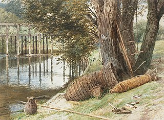
An eel buck or eel basket is a type of fish trap that was prevalent in the River Thames in England up to the 20th century. It was used particularly to catch eels, which were a staple part of the London diet.

Kozubów is a village in the administrative district of Gmina Pińczów, within Pińczów County, Świętokrzyskie Voivodeship, in south-central Poland. It lies approximately 12 kilometres (7 mi) south of Pińczów and 51 km (32 mi) south of the regional capital Kielce.
Kolonia Ossa is a village in the administrative district of Gmina Odrzywół, within Przysucha County, Masovian Voivodeship, in east-central Poland.

Marydół is a village in the administrative district of Gmina Ostrzeszów, within Ostrzeszów County, Greater Poland Voivodeship, in west-central Poland. It lies approximately 13 kilometres (8 mi) north-west of Ostrzeszów and 122 km (76 mi) south-east of the regional capital Poznań.
Inates is a village and rural commune in Niger.
Sepa is a village in Saaremaa Parish, Saare County in western Estonia.

Arena Lublin is a football stadium located in Lublin, Poland. It is the home ground of Motor Lublin. The stadium holds 15,500 people. It is one of the venues for the 2019 FIFA U-20 World Cup.


