
Lublin Voivodeship, or Lublin Province, is a voivodeship, or region, located in southeastern Poland. It was created on January 1, 1999, out of the former Lublin, Chełm, Zamość, Biała Podlaska and (partially) Tarnobrzeg and Siedlce Voivodeships, pursuant to Polish local government reforms adopted in 1998. The region is named after its largest city and regional capital, Lublin, and its territory is made of four historical lands: the western part of the voivodeship, with Lublin itself, belongs to Lesser Poland, the eastern part of Lublin Area belongs to Red Ruthenia, and the northeast belongs to Polesie and Podlasie.

Zamość County is a unit of territorial administration and local government (powiat) in Lublin Voivodeship, eastern Poland. It was established on January 1, 1999, as a result of the Polish local government reforms passed in 1998. Its administrative seat is the city of Zamość, although the city is not part of the county. The county contains three towns: Szczebrzeszyn, which lies 21 km (13 mi) west of Zamość, Zwierzyniec, which lies 24 km (15 mi) south-west of Zamość, and Krasnobród, 22 km (14 mi) south of Zamość.

Puławy County is a unit of territorial administration and local government (powiat) in Lublin Voivodeship, eastern Poland. It was first established in 1867, but its current borders were established on January 1, 1999, as a result of the Polish local government reforms passed in 1998. Its administrative seat and largest town is Puławy, which lies 46 kilometres (29 mi) north-west of the regional capital Lublin. The county also contains the towns of Nałęczów, lying 23 km (14 mi) south-east of Puławy, and Kazimierz Dolny, 11 km (7 mi) south of Puławy.

Biłgoraj County is a unit of territorial administration and local government (powiat) in Lublin Voivodeship, eastern Poland. It was established on January 1, 1999, as a result of the Polish local government reforms passed in 1998. Its administrative seat and largest town is Biłgoraj, which lies 79 kilometres (49 mi) south of the regional capital Lublin. The county contains three other towns: Tarnogród, lying 21 km (13 mi) south of Biłgoraj, Józefów, lying 24 km (15 mi) east of Biłgoraj, and Frampol, 16 km (10 mi) north of Biłgoraj.

Hrubieszów County is a unit of territorial administration and local government (powiat) in Lublin Voivodeship, eastern Poland, on the border with Ukraine. It was established on January 1, 1999, as a result of the Polish local government reforms passed in 1998. Its administrative seat and only town is Hrubieszów, which lies 104 kilometres (65 mi) south-east of the regional capital Lublin.

Lubartów County is a unit of territorial administration and local government (powiat) in Lublin Voivodeship, eastern Poland. It was established on January 1, 1999, as a result of the Polish local government reforms passed in 1998. Its administrative seat and largest town is Lubartów, which lies 25 kilometres (16 mi) north of the regional capital Lublin. The county also contains the towns of Kock, lying 23 km (14 mi) north-west of Lubartów, and Ostrów Lubelski, 18 km (11 mi) east of Lubartów.
Chełm County is a unit of territorial administration and local government (powiat) in Lublin Voivodeship, eastern Poland, on the border with Ukraine. It was established on January 1, 1999, as a result of the Polish local government reforms passed in 1998. Its administrative seat is the city of Chełm, although the city is not part of the county. The only town in Chełm County is Rejowiec Fabryczny, which lies 17 km (11 mi) west of Chełm.

Parczew County is a unit of territorial administration and local government (powiat) in Lublin Voivodeship, eastern Poland. It was established on January 1, 1999, as a result of the Polish local government reforms passed in 1998. Its administrative seat and only town is Parczew, which lies 48 kilometres (30 mi) north-east of the regional capital Lublin.

Włodawa County is a unit of territorial administration and local government (powiat) in Lublin Voivodeship, eastern Poland, on the border with Ukraine and Belarus. It was established on January 1, 1999, as a result of the Polish local government reforms passed in 1998. Its administrative seat and only town is Włodawa, which lies 76 kilometres (47 mi) north-east of the regional capital Lublin.

Ryki County is a unit of territorial administration and local government (powiat) in Lublin Voivodeship, eastern Poland. It was established on January 1, 1999, as a result of the Polish local government reforms passed in 1998. Its administrative seat is the town of Ryki, which lies 62 kilometres (39 mi) north-west of the regional capital Lublin. The only other town in the county is Dęblin, lying 9 km (6 mi) south-west of Ryki.

Kraśnik County is a unit of territorial administration and local government (powiat) in Lublin Voivodeship, eastern Poland. It was established on January 1, 1999, as a result of the Polish local government reforms passed in 1998. Its administrative seat and largest town is Kraśnik, which lies 45 kilometres (28 mi) south-west of the regional capital Lublin. The only other town in the county is Annopol, lying 25 km (16 mi) west of Kraśnik.

Łuków County is a unit of territorial administration and local government (powiat) in Lublin Voivodeship, eastern Poland. It was established on January 1, 1999, as a result of the Polish local government reforms passed in 1998. Its administrative seat and largest town is Łuków, which lies 76 kilometres (47 mi) north of the regional capital Lublin. The only other town in the county is Stoczek Łukowski, lying 30 km (19 mi) west of Łuków.

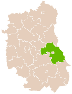
Łęczna County is a unit of territorial administration and local government (powiat) in Lublin Voivodeship, eastern Poland. It was established on January 1, 1999, as a result of the Polish local government reforms passed in 1998. Its administrative seat and only town is Łęczna, which lies 23 kilometres (14 mi) east of the regional capital Lublin.

Janów Lubelski County is a unit of territorial administration and local government (powiat) in Lublin Voivodeship, eastern Poland. It was established on January 1, 1999, as a result of the Polish local government reforms passed in 1998. Its administrative seat and only town is Janów Lubelski, which lies 60 kilometres (37 mi) south of the regional capital Lublin.

Świdnik County is a unit of territorial administration and local government (powiat) in Lublin Voivodeship, eastern Poland. It was established on January 1, 1999, as a result of the Polish local government reforms passed in 1998. Its administrative seat and largest city is Świdnik, which lies 10 kilometres (6 mi) east of the regional capital Lublin. The only other town in the county is Piaski, lying 14 km (9 mi) south-east of Świdnik.

Radzyń Podlaski County is a unit of territorial administration and local government (powiat) in Lublin Voivodeship, eastern Poland. It was established on January 1, 1999, as a result of the Polish local government reforms passed in 1998. Its administrative seat and only town is Radzyń Podlaski, which lies 60 kilometres (37 mi) north of the regional capital Lublin.

Tomaszów County is a unit of territorial administration and local government (powiat) in Lublin Voivodeship, eastern Poland, on the border with Ukraine. It was established on January 1, 1999, as a result of the Polish local government reforms passed in 1998. Its administrative seat and largest town is Tomaszów Lubelski, which lies 107 kilometres (66 mi) south-east of the regional capital Lublin. The only other towns in the county are Tyszowce, lying 28 km (17 mi) north-east of Tomaszów, and Łaszczów, lying 25 km (16 mi) east of Tomaszów.
Urzędów County was a powiat (county) within Lublin Voivodeship in the Polish–Lithuanian Commonwealth. Today, Urzędów belongs to the Kraśnik County.

Lublin Voivodeship was an administrative region of the Kingdom of Poland created in 1474 out of three eastern counties of Sandomierz Voivodeship and lasting until the Partitions of Poland in 1795. Together with Sandomierz Voivodeship and Kraków Voivodeship, it was part of historic Lesser Poland. Lublin Voivodeship had two senators in the Senate of the Kingdom of Poland: the Voivode and the Castellan of Lublin. Local sejmiks took place in Lublin.
Gmina Spiczyn is a rural gmina in Łęczna County, Lublin Voivodeship, in eastern Poland. Its seat is the village of Spiczyn, which lies approximately 10 kilometres (6 mi) north-west of Łęczna and 18 km (11 mi) north-east of the regional capital Lublin.


