
Lake Louise is a hamlet within Banff National Park in Alberta, Canada. Named after Princess Louise, Duchess of Argyll, it lies in Alberta's Rockies on the Bow River, 3 km (1.9 mi) northeast of the lake that shares its name. Initially settled in 1884 as an outpost for the Canadian Pacific Railway, Lake Louise sits at an elevation of 1,600 m (5,200 ft), making it Canada's highest community. The nearby lake, framed by mountains, is one of the most famous mountain vistas in the world.

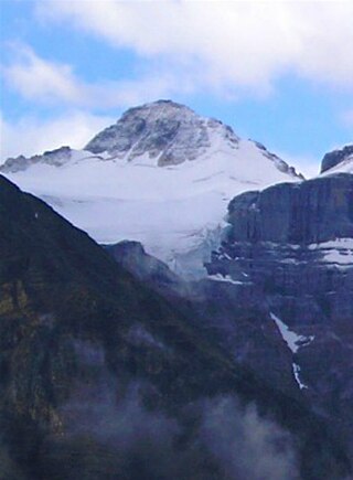
Mount Columbia is a mountain located in the Winston Churchill Range of the Rocky Mountains. It is the highest point in Alberta, Canada, and is second only to Mount Robson for height and topographical prominence in the Canadian Rockies. It is located on the border between Alberta and British Columbia on the northern edge of the Columbia Icefield. Its highest point, however, lies within Jasper National Park in Alberta.

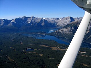
Alberta is one of the thirteen provinces and territories of Canada. Located in Western Canada, the province has an area of 661,190 km2 (255,290 sq mi) and is bounded to the south by the United States state of Montana along 49° north for 298 km (185 mi); to the east at 110° west by the province of Saskatchewan for 1,223 km (760 mi); and at 60° north the Northwest Territories for 644 km (400 mi). The southern half of the province borders British Columbia along the Continental Divide of the Americas on the peaks of the Rocky Mountains, while the northern half borders British Columbia along the 120th meridian west. Along with Saskatchewan it is one of only two landlocked provinces or territories.

Mount Temple is a mountain in Banff National Park of the Canadian Rockies of Alberta, Canada.

The Cypress Hills are a geographical region of hills in southwestern Saskatchewan and southeastern Alberta, Canada. The hills are part of the Missouri Coteau upland. The hills cover an area of approximately 2,500 km2 (970 sq mi). About 400 km2 (150 sq mi) or 16% of this area is an interprovincial park.

Mount Bryce is a mountain at the southwestern corner of the Columbia Icefield, in British Columbia, Canada, near the border with Alberta. It can be seen from the Icefields Parkway.

Mount Brazeau is a mountain in Alberta, Canada.

The Blue Range is a mountain range of the Canadian Rockies, located on the Continental Divide in Banff National Park, Canada. The range was so named on account of its blueish colour when viewed from afar. Mount Alcantara is the highest point in the range.
Rochfort Bridge is a hamlet in Alberta, Canada within Lac Ste. Anne County. It is located approximately 105 kilometres (65 mi) northwest of Edmonton and 8 kilometres (5.0 mi) east of Mayerthorpe. Rochfort Bridge is named for Cooper (Cowper) Rochfort, who with his associate, Percy Michaelson, homesteaded on the Paddle River at the point where the old trail from Lac Ste. Anne to the MacLeod River crossed the Paddle River.

Mount Hector is a 3,394-metre (11,135-foot) mountain summit located in the Bow River valley of Banff National Park, in the Canadian Rockies of Alberta, Canada. The mountain was named in 1884 by George M. Dawson after James Hector, a geologist on the Palliser expedition. The mountain is located beside the Icefields Parkway, 17 km (11 mi) north of Lake Louise.

Abbot Pass lies between Mount Lefroy and Mount Victoria, in the divide between the valleys of Lake O'Hara and Lake Louise. It was named for Philip Stanley Abbot who died in 1896 in an attempt to climb Mount Lefroy with Charles Fay, Charles Thompson, and George T. Little.
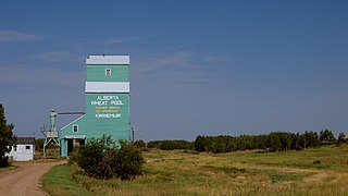
Kirriemuir is hamlet in east-central Alberta, Canada within Special Area No. 4. It is located on Highway 12, approximately 12 kilometres (7.5 mi) west of Altario. It has an elevation of 730 metres (2,400 ft).
Falun is a hamlet in central Alberta, Canada within the County of Wetaskiwin No. 10. It is located on Highway 13, approximately 31 kilometres (19 mi) west of Wetaskiwin.
Mount Farnham is British Columbia's 17th highest peak, and 21st most prominent. It was named after Paulding Farnham from New York. It is the highest peak in the Purcells.
Mount Little is situated at the northern end of Kootenay National Park, and straddles the Continental Divide marking the Alberta-British Columbia border. It was named in 1916 after George F. Little, a member of the first ascent party.

The Towers is a 2,842-metre (9,324-foot) mountain located on the border of Alberta and British Columbia on the Continental Divide. It also straddles the shared boundary of Banff National Park with Mount Assiniboine Provincial Park. It was named in 1917 by Arthur O. Wheeler. Its nearest higher peak is Mount Magog, 2.5 km (1.6 mi) to the west.

Mount Worthington is located on the eastern side of Mount McHarg, in Height of the Rockies Provincial Park, and straddles the Continental Divide marking the Alberta-British Columbia border. It was named in 1956 after Lt. Col. Don Worthington who was killed in action in 1944 during the Second World War while commanding the 7th Battalion, The British Columbia Regiment.
Mount Cordonnier is located north of Mount Joffre in Height of the Rockies Provincial Park and straddles the Continental Divide marking the Alberta-British Columbia border. It was named in 1918 after General Victor Louis Emilien Cordonnier.
Mount Mangin is located on the border of Alberta and British Columbia on the Continental Divide. It was named in 1918 after French general Charles Mangin.

The Spray Mountains is a mountain range of the Canadian Rockies located in southwestern Alberta, Canada.
