Queensland is the second largest state in Australia. It contains around 500 separate protected areas. In 2020, it was estimated a total of 14.2 million hectares or 8.25% of Queensland's landmass was protected.
Bunya Mountains is a national park in the South Burnett Region, Queensland, Australia.
Glass House Mountains National Park is a heritage-listed national park at Glass House Mountains, Sunshine Coast Region, Queensland, Australia. It is also known as Beerburrum Forest Reserve 1. It is 70 km (43 mi) north of Brisbane and consists of a flat plain punctuated by rhyolite and trachyte volcanic plugs, the cores of extinct volcanoes that formed 27 million to 26 million years ago. The mountains would once have had pyroclastic exteriors, but these have eroded away.

The Main Range is a mountain range and national park in Queensland, Australia, located predominantly in Tregony, Southern Downs Region, 85 kilometres (53 mi) southwest of Brisbane. It is part of the World Heritage Site Gondwana Rainforests of Australia. It protects the western part of a semicircle of mountains in South East Queensland known as the Scenic Rim. This includes the largest area of rainforest in South East Queensland. The park is part of the Scenic Rim Important Bird Area, identified as such by BirdLife International because of its importance in the conservation of several species of threatened birds.

Baga National Park is a national park in Queensland, Australia, 531 kilometres (330 mi) northwest of Brisbane.

"Jump Jim Crow" or "Jim Crow" is a song and dance from 1828 that was done in blackface by white minstrel performer Thomas Dartmouth "Daddy" Rice. The song is speculated to have been taken from Jim Crow, a physically disabled enslaved African-American, who is variously claimed to have lived in St. Louis, Cincinnati, or Pittsburgh. The song became a 19th-century hit and Rice performed it all over the United States as "Daddy Pops Jim Crow".

The Mulanje Massif, also known as Mount Mulanje, is a large inselberg in southern Malawi. Sapitwa Peak, the highest point on the massif at 3,002 m, is the highest point in Malawi. It lies 65 km east of Blantyre, rising sharply from the surrounding plains of Phalombe and the Mulanje district.

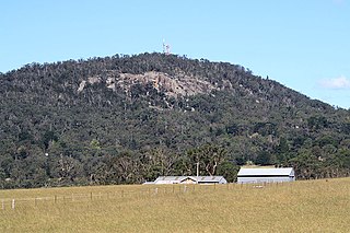
Gai-i is a small mountain situated between Rockhampton and Yeppoon in the state of Queensland, Australia. It is one of several igneous volcanic plug formations that feature on the landscape near the Capricorn Coast. The mountain is situated on a site known as Gawula, which is administered by the Gawula Aboriginal Land Trust. Traditionally home to a group of Aboriginal Australians known as the Darumbal people, it was returned to them in 2007 under the Aboriginal Land Act.

Mount Taylor is a dormant stratovolcano in northwest New Mexico, northeast of the town of Grants. It is the high point of the San Mateo Mountains and the highest point in the Cibola National Forest.
Mount Gibraltar is a mountain with an elevation of 863 metres (2,831 ft) AHD that is located in the Southern Highlands region, between Bowral and Mittagong, in New South Wales, Australia. Further west is Berrima.

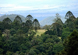
The Bunya Mountains are a distinctive set of peaks forming an isolated section of the Great Dividing Range in southern Queensland. The mountain range forms the northern edge of the Darling Downs in the locality also called Bunya Mountains near Bell and Dalby. The mountains are south of Kingaroy and just to the south west of Nanango. The range is the remains of a shield volcano which was built from numerous basalt lava flows about 23-24 million years ago.
Tamborine Mountain is a plateau and locality in the Scenic Rim Region, Queensland, Australia. In the 2016 census, Tamborine Mountain had a population of 7,506 people.

Zerok District, also spelled Zirok, is a district of Paktika Province that once was a part of Paktia, Afghanistan. The main town is Zerok located on the main Khost-Urgun road.

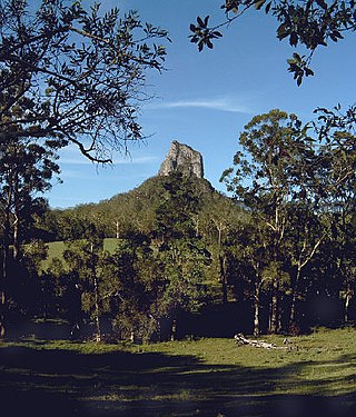
The Glass House Mountains are a cluster of thirteen hills that rise abruptly from the coastal plain on the Sunshine Coast, Queensland, Australia. The highest hill is Mount Beerwah at 556 metres above sea level, but the most identifiable of all the hills is Mount Tibrogargan which from certain angles bears a resemblance to a face staring east towards the ocean. The Glass House Mountains are located near Beerburrum State Forest and Steve Irwin Way. From Brisbane, the mountains can be reached by following the Bruce Highway north and taking the Glass House Mountains tourist drive turn-off onto Steve Irwin Way. The trip is about one hour from Brisbane. The Volcanic peaks of the Glass House Mountains rise dramatically from the surrounding Sunshine Coast landscape. They were formed by intrusive plugs, remnants of volcanic activity that occurred 26–27 million years ago. Molten rock filled small vents or intruded as bodies beneath the surface and solidified into land rocks. Millions of years of erosion have removed the surrounding exteriors of volcanic cores and softer sandstone rock.
The Cambanoora Gorge runs between the source of the Condamine River and the town of Killarney in Queensland, Australia. It is not officially named and is also known as the Condamine Gorge and the 14 River Crossings.
The Berserker Range is a mountainous region located on the eastern and northeastern boundary of the city of Rockhampton in Central Queensland, Australia. Within it lies Mount Archer National Park. It has been designated the Berserker Range Environmental Protection Area by the Rockhampton Regional Council. The southernmost part of the range reaches the Fitzroy River at Broadmount, east of Rockhampton.
The Twenty-Nine Palms Band of Mission Indians of California is a federally recognized tribe of Mission Indians with a reservation consisting of two sections, one located near the cities of Indio and Coachella in Riverside County, and the other in the city of Twentynine Palms in San Bernardino County, California. While many scholars regard the tribe as being Luiseño, the tribe itself identifies as being Chemehuevi.
The Darumbal people, also spelt Dharumbal, are the Aboriginal Australians that have traditionally occupied Central Queensland, speaking dialects of the Darumbal language. Darumbal people of the Keppel Islands and surrounding regions are sometimes also known as Woppaburra or Ganumi, and the terms are sometimes used interchangeably.

The South Eastern Highlands is an interim Australian bioregion in eastern Australia, that spans parts of the states and territories of New South Wales, the Australian Capital Territory, and Victoria. The bioregion comprises 8,375,961 hectares and is approximately 3,860 kilometres (2,400 mi) long. The Australian Alps as well as the South West Slopes bound the region from the south and west; and to the northeast, the Sydney Basin bioregion, as well as the bioregion of the South East Corner, to the east.
The Pulana or Mapulana, are a low-veld Tsonga-Pedi ethnic group found in Bushbuckridge near Mpumalanga and Limpopo provinces. Their language is called Sepulana and is considered dialect of the Northern language group.