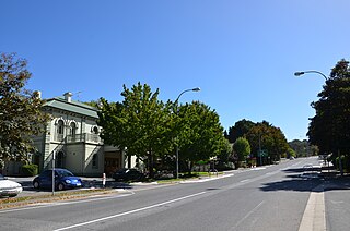
The town of Crafers is in the Adelaide Hills to the south-east of Adelaide, South Australia. Although technically considered to be an outer suburb of Adelaide, with many residents commuting to the city to work, locals consider Crafers to be more a suburb of the nearby township of Stirling.

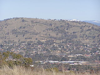
Mount Barker is a city in South Australia. Located approximately 33 kilometres from the Adelaide city centre, it is home to 16,629 residents. It is the seat of the District Council of Mount Barker, the largest town in the Adelaide Hills, and one of the fastest growing areas in the state.

The Adelaide Hills region is located in the southern Mount Lofty Ranges east of the city of Adelaide in the state of South Australia. The largest town in the area, Mount Barker, has a population of around 29,000 and is one of Australia's fastest growing towns.

Mount Lofty is the highest point in the southern Mount Lofty Ranges. It is located about 15 km east of the Adelaide city centre in South Australia, and has panoramic views of the city and the Adelaide plains to the west, and of the Picadilly Valley to the east.

The Mount Lofty Ranges are the range of mountains just to the east of Adelaide in the Australian state of South Australia.
Mount Taylor is a prominent hill with an elevation of 856 metres (2,808 ft) AHD that is located between the Woden Valley, Weston Creek district and Tuggeranong Valley, in Canberra, within the Australian Capital Territory, Australia. Mount Taylor is part of the Canberra Nature Park and is surrounded by the suburbs of Kambah, Fisher, Waramanga, Chifley, Pearce, and Torrens. There are walking tracks to the peak. While there is no public road access to the peak there is a fire trail up the mountain from the end of Waldock St, Chifley where there is also a car park and picnic tables. The fire trail is normally closed to public vehicular access by locked gates, but the gates contain access points for walkers. The trail is especially popular with families and older walkers as it provides the easiest and most leisurely access to the peak. Originally a dirt road, it was partially sealed in 2009 on the steeper grades to make it safer for walkers and mountain bike riders.

Mount Osmond is a small suburb of 2,497 people in the South Australian capital city of Adelaide. It is part of the City of Burnside local government area and located in the foothills of the Adelaide Hills, five kilometres south east of the city centre. The suburb is high on the hill of the same name, which is the last hill on the right when approaching Adelaide down the South Eastern Freeway before the road levels out onto the Adelaide Plains. It is bounded to the north by the suburb of Beaumont, to the north-east by Burnside, to the east by Waterfall Gully, to the south by Leawood Gardens/Eagle On The Hill, to the south-west by Urrbrae, to the west by Glen Osmond and to the north-west by St Georges.

The town of Clare is located in South Australia in the Mid North region, 136 km north of Adelaide. It gives its name to the Clare Valley wine and tourist region.

Totness Recreation Park is a protected area in the Australian state of South Australia located within the localities of Mount Barker and Totness in the central Mount Lofty Ranges. Covering 41 hectares of land, the park is divided by the South Eastern Freeway and features a large dam. It was declared as a reserve in 1970 and re-designated as a recreation park in 1972. The park has no visitor facilities except for access tracks. It is the only park in the district, managed by the Department of Environment and Water, that is solely designated for recreation.

Mount Pleasant is a town situated in the Barossa Council, just north of the Adelaide Hills region of South Australia, 55 kilometres east-north-east of the state capital, Adelaide. It is located in the Barossa Council and Mid Murray Council local government areas, and is at an altitude of 440 metres above sea level. Rainfall in the area averages 687 mm per annum.

Black Hill Conservation Park, formerly the Black Hill National Park, is a protected area in the Australian state of South Australia located approximately 10 kilometres (6.2 mi) northeast of the state capital of Adelaide. The conservation park is in a rugged bush environment, with a prominent peak, bounded by steep ridges on the southern slopes.

The Little Para River is a seasonal creek running across the Adelaide Plains in the Australian state of South Australia, whose catchment fills reservoirs that supply some of the water needs of Adelaide’s northern suburbs.
Mount Crawford is a hill in the locality also named Mount Crawford in South Australia approximately 15 kilometres (9.3 mi) north of Birdwood in the Mount Lofty Ranges.

Mount Magnificent Conservation Park is a protected area in the Australian state of South Australia located in the Mount Lofty Ranges about 58 kilometres south of the state capital of Adelaide. It is located within the gazetted locality of Mount Magnificent.

Finniss Conservation Park is a protected area in the Australian state of South Australia located in the Mount Lofty Ranges about 43 kilometres south of the state capital of Adelaide and about 7 kilometres west of Ashbourne. It is located within the gazetted locality of Mount Magnificent.

The Bremer River, part of the lower Murray-Darling catchment, is a river that is located in the Adelaide Hills region in the Australian state of South Australia.
James Rigby Beevor (1811–1849) was a pioneer colonist and pastoralist of South Australia and a murder victim of the Australian frontier wars. Mount Beevor in South Australia is named after him.
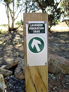
The Lavender Federation Trail is a long distance walking trail in the eastern Mount Lofty Ranges in South Australia. It extends 325 kilometres (202 mi) from Murray Bridge to Clare. It is named after Terry Lavender OAM and development started in 1999.

The County of Hindmarsh is one of the 49 cadastral counties of South Australia. It was proclaimed by Governor George Grey in 1842 and named for Governor John Hindmarsh.
Kinchina Conservation Park is a protected area in the Australian state of South Australia in the north of the Gifford Hill Range on the eastern flanks the localities of Rocky Gully and White Hill, west of Murray Bridge.
