
Galilee is a region located in northern Israel and southern Lebanon. Galilee traditionally refers to the mountainous part, divided into Upper Galilee and Lower Galilee.
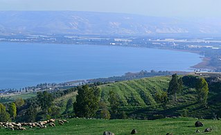
The Sea of Galilee, also called Lake Tiberias or Kinneret, is a freshwater lake in Israel. It is the lowest freshwater lake on Earth and the second-lowest lake in the world, at levels between 215 and 209 metres below sea level. It is approximately 53 km (33 mi) in circumference, about 21 km (13 mi) long, and 13 km (8.1 mi) wide. Its area is 166.7 km2 (64.4 sq mi) at its fullest, and its maximum depth is approximately 43 metres (141 ft). The lake is fed partly by underground springs, but its main source is the Jordan River, which flows through it from north to south and exits the lake at the Degania Dam.

Tiberias is an Israeli city on the western shore of the Sea of Galilee. A major Jewish center during Late Antiquity, it has been considered since the 16th century one of Judaism's Four Holy Cities, along with Jerusalem, Hebron, and Safed. In 2022, it had a population of 48,472.

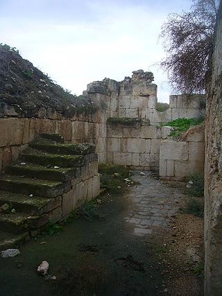
Capernaum was a fishing village established during the time of the Hasmoneans, located on the northern shore of the Sea of Galilee. It had a population of about 1,500 in the 1st century AD. Archaeological excavations have revealed two ancient synagogues built one over the other. A house turned into a church by the Byzantines is held by Christian tradition to have been the home of Saint Peter.

Magdala was an ancient Jewish city on the shore of the Sea of Galilee, 5 km north of Tiberias. In the Babylonian Talmud it is known as Magdala Nunayya, and which some historical geographers think may refer to Tarichaea, literally: "the place of processing fish." It is believed to be the birthplace of Mary Magdalene. Until the 1948 Arab–Israeli War, a small Arab village, al-Majdal, stood at the site of ancient Magdala. The Israeli municipality of Migdal now extends into the area.

The archaeology of Israel is the study of the archaeology of the present-day Israel, stretching from prehistory through three millennia of documented history. The ancient Land of Israel was a geographical bridge between the political and cultural centers of Mesopotamia and Egypt.

Bethsaida, also known as Julias or Julia, is a place mentioned in the New Testament. Julias lay in an administrative district known as Gaulonitis. Historians have suggested that the name is also referenced in rabbinic literature under the epithet Ṣaidan.

Ehud Netzer was an Israeli architect, archaeologist and educator, known for his extensive excavations at Herodium, where in 2007 he found the tomb of Herod the Great; and the discovery of a structure defined by Netzer as a synagogue, which if true would be the oldest one ever found.
Kursi is an archaeological site in the Golan Heights containing the ruins of a Byzantine monastery and identified by tradition as the site of Jesus' "Miracle of the Swine". Part of the archaeological site is now an Israeli national park. Kursi takes its name from the Talmudic site. A marble slab with Aramaic text discovered in December 2015 seems to indicate that the settlement had, as of c. 500 CE, a Jewish or Judeo-Christian population.
Khirbet Kerak or Beth Yerah is a tell located on the southern shore of the Sea of Galilee in modern-day Israel. The tell spans an area of over 50 acres—one of the largest in the Levant—and contains remains dating from the Early Bronze Age and from the Persian period through to the Early Islamic period.
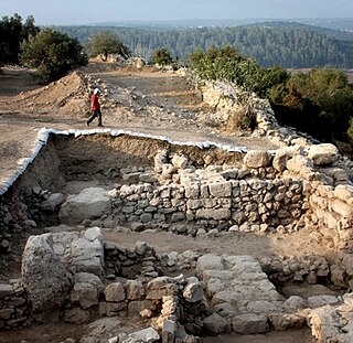
KhirbetQeiyafa, also known as Elah Fortress and in Hebrew as Horbat Qayafa, is the site of an ancient fortress city overlooking the Elah Valley and dated to the first half of the 10th century BCE. The ruins of the fortress were uncovered in 2007, near the Israeli city of Beit Shemesh, 30 km (20 mi) from Jerusalem. It covers nearly 2.3 ha and is encircled by a 700-meter-long (2,300 ft) city wall constructed of field stones, some weighing up to eight tons. Excavations at site continued in subsequent years. A number of archaeologists, mainly the two excavators, Yosef Garfinkel and Saar Ganor, have claimed that it might be one of two biblical cities, either Sha'arayim, whose name they interpret as "Two Gates", because of the two gates discovered on the site, or Neta'im; and that the large structure at the center is an administrative building dating to the reign of King David, where he might have lodged at some point. This is based on their conclusions that the site dates to the early Iron IIA, ca. 1025–975 BCE, a range which includes the biblical date for the biblical Kingdom of David. Others suggest it might represent either a North Israelite, Philistine, or Canaanite fortress, a claim rejected by the archaeological team that excavated the site. The team's conclusion that Khirbet Qeiyafa was a fortress of King David has been criticised by some scholars. Garfinkel (2017) changed the chronology of Khirbet Qeiyafa to ca. 1000–975 BCE.
Yizhar Hirschfeld was an Israeli archaeologist studying Greco-Roman and Byzantine archaeology. He was an associate professor at the Hebrew University of Jerusalem and director of excavations at a number of sites around Israel, including Ramat Hanadiv, Tiberias, and Khirbet ed-Deir. He also published a book on the archaeology of Qumran in which he proposed an assessment of the site that was contrary to prevailing views.

Ramat Hanadiv, is a nature park and garden in northern Israel, covering 4.5 km (3 mi) at the southern end of Mount Carmel between Zikhron Ya'akov to the north and Binyamina to the south. The Jewish National Fund planted pine and cypress groves in most of the area.

The architecture of Palestine covers a vast historical time frame and a number of different styles and influences over the ages. The urban architecture of the region of Palestine prior to 1850 was relatively sophisticated. The Palestinian townhouse shared in the same basic conceptions regarding the arrangement of living space and apartment types commonly seen throughout the Eastern Mediterranean. The rich diversity and underlying unity of the architectural culture of this wider region stretching from the Balkans to North Africa was a function of the exchange fostered by the caravans of the trade routes, and the extension of Ottoman rule over most of this area, beginning in the early 16th century through until the end of World War I.
Khirbat al-Minya, also known as Ayn Minyat Hisham (Arabic) or Horvat Minnim (Hebrew) is an Umayyad-built palace in the eastern Galilee, Israel, located about 200 meters (660 ft) west of the northern end of Lake Tiberias. It was erected as a qasr complex, with a palace, mosque, and bath built by a single patron.

Tzippori Synagogue is an ancient synagogue discovered in Sepphoris, a Roman-era Jewish city in the Galilee, now an archaeological site and a national park in Israel.
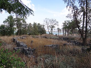
Al-Sinnabra or Sinn en-Nabra, is the Arabic place name for a historic site on the southern shore of the Sea of Galilee in modern-day Israel. The ancient site lay on a spur from the hills that close the southern end of the Sea of Galilee, next to which towards its south being the tell, Khirbet Kerak or Bet Yerah, one of the largest in the Levant, spanning an area of over 50 acres. Bet Yerah was the Hellenistic era twin city of Sennabris, as al-Sinnabra was known in Classical antiquity, and its remains are located at the same tell.

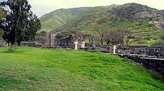
Hammath Tiberias or Hammat Tiberias is an ancient archaeological site and an Israeli national park known as Hamat Tverya National Park, which is located on the adjacent to Tiberias on the road to Zemach that runs along the shore of the Sea of Galilee.

Huqoq or Hukkok was an ancient Jewish village, located 12.5 km north of Tiberias. The area had been settled since ancient times and is mentioned in the Book of Joshua. The Palestinian village of Yaquq later stood at Huqoq's location, and a fort named Hukok was built near the site on 11 July 1945, later followed by a kibbutz.

Horvat Eleq is located in the southeastern area of Ramat HaNadiv, at the southern edge of Mount Carmel at an altitude of 141 meters above sea level. It is a multi-layered site with a prolonged and almost continuous human activity from the Middle Paleolithic period until the Byzantine period and then the Ottoman period. Horvat Eleq dominates the route of two historic roads – one extends from the Israeli coastal plain eastward along Nahal Taninim to the Jezreel Valley, and the other extends northward along the Israeli coastal plain and bypasses Mount Carmel to the north. Both roads were paved in the early Roman period as part of the imperial Roman road network. Nearby within 10 km are the cities of Dor, Caesarea and their ports, Tel Taninim and Tel Mevorakh to the west and Tel Burga to the southeast.

