
Banks Peninsula is a peninsula of volcanic origin on the east coast of the South Island of New Zealand. It has an area of approximately 1,200 square kilometres (450 sq mi) and encompasses two large harbours and many smaller bays and coves. The South Island's largest city, Christchurch, is immediately north of the peninsula.

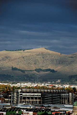
The Port Hills are a range of hills in Canterbury Region of New Zealand, so named because they lie between the city of Christchurch and its port at Lyttelton. They are an eroded remnant of the Lyttelton volcano, which erupted millions of years ago.

Lyttelton is a port town on the north shore of Lyttelton Harbour / Whakaraupō, at the northwestern end of Banks Peninsula and close to Christchurch, on the eastern coast of the South Island of New Zealand.

Opawa is an inner residential suburb of Christchurch, New Zealand. It is located approximately 3.5 kilometres south-east of the city centre. Initally Opawa was a low-lying area, and a continuation of the Sydenham swamp. By the 1860s, the area was sparsely populated by European settlers and later became a rural-agricultural locality, with many of the early settlers of English descent. As Woolston emerged as an industrial hub nearby, Opawa was heavily urbanised, transforming it into an upscale residential area and its population largely included factory workers and businesspeople. Notable heritage-listed buildings in the suburb include "Risingholme" and "The Hollies". In its formative days, Opawa was a riding of the Heathcote County Council. It later amalgamated in to the city area in 1916.

Heathcote Valley is a suburb of Christchurch, New Zealand. It is named after Sir William Heathcote, who was secretary of the Canterbury Association.

The Bridle Path is a steep shared-use track that traverses the northern rim of the Lyttelton volcano connecting the port of Lyttelton with the city of Christchurch in the South Island of New Zealand. It is a popular walking and mountain biking route. The track ascends from the port itself to a height of 333 metres (1,093 ft) before descending again via Heathcote Valley to Christchurch. At the summit, next to the Summit Road, is a stone shelter with covered seats that is a 1940 New Zealand centennial memorial to the Pioneer Women of Canterbury. There are also seven commemorative stone seats placed along the Bridle Path; most of these were built for the 1950 Canterbury centenary celebrations.

The Sign of the Takahe is a neo-Gothic style historic building in Christchurch, New Zealand. It is currently leased from Christchurch City Council and run as a pop in cafe, bar, and now focuses on wedding & functions.

Henry George Ell, commonly known as Harry Ell, was a Christchurch City councillor and a New Zealand Member of Parliament. He is famous for his conservation work around Christchurch's Port Hills, his advocacy for the Summit Road, and his construction of the Sign of the Takahe and other road houses along the Summit Road.

Lyttelton Harbour / Whakaraupō is a major inlet on the northwest side of Banks Peninsula, on the coast of Canterbury, New Zealand; the other major inlet is Akaroa Harbour, which enters from the southern side of the peninsula. Whakaraupō enters from the northern coast of the peninsula, heading in a predominantly westerly direction for approximately 15 km (9.3 mi) from its mouth to the aptly-named Head of the Bay near Teddington. The harbour sits in an eroded caldera of the ancient Banks Peninsula Volcano, the steep sides of which form the Port Hills on its northern shore.

The Lyttelton road tunnel runs through the Port Hills to connect the New Zealand city of Christchurch and its seaport, Lyttelton. It opened in on 27 February 1964 and carries just over 10,000 vehicles per day as part of State Highway 74.
The Christchurch–Lyttelton Motorway, also known as Tunnel Road, is part of the road network connecting Christchurch, New Zealand with its port at Lyttelton. It is part of State Highway 74.
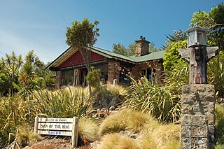
The Sign of the Kiwi, originally called Toll House, is a small café and shop at Dyers Pass on the road between Christchurch and Governors Bay. It was built in 1916–17 by Harry Ell as a staging post and opened as a tearoom and rest house. It has a Category I heritage classification by Heritage New Zealand and is a popular destination for tourists and locals alike. The building was closed some time after the 22 February 2011 Christchurch earthquake and did not open again until 23 January 2017, six years later. Although located within the burned area, the building was not damaged by the 2017 Port Hills fires a month later.
Tauhinukorokio / Mount Pleasant, also known just as either Mount Pleasant or Tauhinukorokio individually, is the highest elevation in the eastern Port Hills in Christchurch, New Zealand. It once held a Māori pā, but there was little left of it when European settlers first arrived in the 1840s. The hill was first used as a sheep run, and became the base trig station for the survey of Canterbury. It was also used as a signal station to make residents aware of ships coming into Lyttelton Harbour / Whakaraupō. During World War II, an extensive heavy anti-aircraft artillery (HAA) battery was built near the summit, and the foundations of those buildings still exist.

Ōrongomai / Cass Peak is a hill in the western Port Hills in Christchurch, New Zealand. Its most notable feature is a radar dome that was built on the peak in the late 1980s, which is used for aircraft positioning services.
St Andrews Hill is a hillside suburb in south-east Christchurch, New Zealand.

The Christchurch Gondola is a tourist attraction service offered by Christchurch Attractions in Christchurch, New Zealand. The gondola base is located in Heathcote Valley, and it traverses the slopes of Mount Cavendish in the Port Hills. Also known as a cable car, the Christchurch Gondola's course is 1,000 metres (1,100 yd) in length, and from the summit it is possible to see across the city of Christchurch and the Canterbury Plains to the Southern Alps in the north and west, and down into Lyttelton Harbour and Banks Peninsula in the south and east. Sometimes used as a transport method for visitors who use the walking tracks on Mt Cavendish, the gondola is ranked as one of the top tourist attractions in Christchurch by TripAdvisor. The summit is 445 metres (1,460 ft) above sea level.

The Canterbury Pioneer Women's Memorial commemorates the pioneer women of Canterbury in New Zealand. After arrival by sea in Lyttelton Harbour, early settlers had to cross the Port Hills via the Bridle Path to reach Christchurch or the Canterbury Plains. The memorial was unveiled at the summit of the Bridle Path in 1940, 90 years after the First Four Ships had arrived in Lyttelton. The impetus for having a memorial was for Christchurch to have a contribution for the New Zealand centennial commemorating the signing of the Treaty of Waitangi in 1840. Hence, the Canterbury Pioneer Women's Memorial commemorates two events that happened ten years apart.
Kennedy's Bush Scenic Reserve is a public conservation reserve in the Port Hills south of Christchurch, New Zealand. It sits above the suburb of Kennedys Bush on the northern side of the hills, just north of Ōrongomai / Cass Peak. The reserve is covered in dense native bush, and at 130 hectares it is the largest remaining patch of native bush on the Port Hills.
Te Tihi-o-Kahukura / Castle Rock is a prominent rock outcrop in the Port Hills above Christchurch, New Zealand. It is a short distance north of Te Moenga-o-Wheke / The Tors, on the northern side of Summit Road. It sits directly to the west of the Bridle Path and the Lyttelton road tunnel. The rocky outcrop itself is 167 metres (548 ft) long, 83 metres (272 ft) wide and up to 24 metres (79 ft) high.

