Related Research Articles

Thatcher Peninsula is a mountainous peninsula in north-central South Georgia. Its total area is approximately 5,640 hectares, with roughly 1,620 ha covered in vegetation. It terminates to the north in Mai Point, rising between Cumberland West Bay to the west, and Cumberland East Bay and Moraine Fjord to the east. It is bounded to the southwest and south by Lyell Glacier and Hamberg Glacier. King Edward Cove on the east side of the peninsula is the site of the British Antarctic Survey (BAS) Grytviken station and the disused whaling station of the same name.
King Edward Cove is a sheltered cove in the west side of Cumberland East Bay, South Georgia. This cove and its surrounding features, frequented by early sealers at South Georgia, was charted by the Swedish Antarctic Expedition, 1901–04, under Otto Nordenskiöld who named it Grytviken. That name, meaning 'Pot Bay,' was subsequently assumed by the whaling station and settlement built in 1904. The cove got its present name in about 1906 for King Edward VII of the United Kingdom.

Cumberland East Bay is a bay forming the eastern arm of Cumberland Bay, South Georgia. It is entered between Sappho Point on Thatcher Peninsula and Barff Point on Barff Peninsula. It is nearly 3 miles (4.8 km) wide, and extends 8 miles (13 km) in a southeast direction.
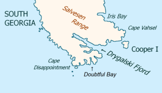
Drygalski Fjord is a bay 1 mile (1.6 km) wide which recedes northwestwards 7 miles (11 km), entered immediately north of Nattriss Head along the southeast coast of South Georgia. It was charted by the Second German Antarctic Expedition, 1911–12, under Wilhelm Filchner, and named for Professor Erich von Drygalski, the leader of the First German Antarctica Expedition, 1901–03.
Hindle Glacier is a glacier 6 miles (10 km) long, flowing north from the vicinity of Mount Paterson into Royal Bay on the north coast of South Georgia. It was surveyed by the South Georgia Survey (SGS), 1951–52. The name "Bruce Glacier" was used unofficially by the British South Georgia Expedition, 1954–55, but a number of Antarctic features are named for Dr. William S. Bruce. The UK Antarctic Place-Names Committee recommended in 1957 that the glacier be named for Dr. Edward Hindle, a British zoologist who, as Honorary Secretary of the Royal Geographical Society, was of great assistance to the SGS expeditions.
Lyell Glacier is a glacier flowing in a northerly direction to Harpon Bay at the southeast head of Cumberland West Bay, South Georgia. It was mapped by the Swedish Antarctic Expedition, 1901–04, under Otto Nordenskjöld, who named it for Sir Charles Lyell, an eminent British geologist.
Gjelstad Pass is a pass through the western part of the Allardyce Range of South Georgia, between Mount Corneliussen and Smillie Peak. It is the only pass yet discovered which gives access overland to the area south of the Allardyce Range. It was surveyed by the South Georgia Survey in the period 1951–57, and was named by the UK Antarctic Place-Names Committee for A. Gjelstad, a Norwegian engineer and factory owner, who between 1926 and 1932 invented various devices of great practical value to the whaling industry, including the "whale-claw," an apparatus for grasping the tails of whales for hauling them up the slipways of factory ships.
Mount Globus is a mountain, 1,270 metres (4,170 ft) high, between Fanning Ridge and Mount Corneliussen at the west end of the Allardyce Range of South Georgia. It was surveyed by the South Georgia Survey in the period 1951–57, and was named by the UK Antarctic Place-Names Committee for Hvalfangerselskapet Globus A/S, a Norwegian whaling company founded in 1924, which first used the plan patented by Petter Sorlle for processing whales in a factory ship fitted with a slipway.
Graae Glacier is a glacier 2 miles (3 km) long on the north side of Mount Sabatier, flowing west-southwest to Trollhul in the south part of South Georgia. It was surveyed by the South Georgia Survey (SGS) in the period 1951–57, and named by the UK Antarctic Place-Names Committee for Mogens E.W. Graae of Denmark, who developed sledges for the SGS, 1953–54 and 1955–56.
Echo Pass is a pass, 305 metres (1,000 ft) in elevation, lying 1.5 miles (2.4 km) southwest of Grytviken, South Georgia, in the chain of mountains which extends southwest from Mount Hodges. The pass provides a ski route from the station at Grytviken to the head of Cumberland West Bay. The name is used on the chart of a German expedition 1928–29, under Kohl-Larsen, who states that the name was already in use by whalers.
Smillie Peak is a rock peak, 1,765 m, standing 1 mile (1.6 km) east of Mount Corneliussen in the west extremity of the Allardyce Range of South Georgia. Surveyed by the SGS, 1951–52, and named by the United Kingdom Antarctic Place-Names Committee (UK-APC) for Gordon Smillie, SGS surveyor.
Esbensen Bay is a small bay 1 nautical mile (2 km) southwest of Nattriss Head, along the southeast end of South Georgia. It was charted by the Second German Antarctic Expedition, 1911–12, under Filchner, and was named for Captain Viktor Esbensen, manager of the Compañía Argentina de Pesca whaling station at Grytviken, the first land-based whaling station in Antarctica.
Helland Glacier is a glacier 4 nautical miles (7 km) long flowing southwest from Mount Paget to Rocky Bay, on the south side of South Georgia. It was mapped by Olaf Holtedahl during his visit to South Georgia in 1927–28, and named by him for Amund Helland, a Norwegian mining geologist and glaciologist.
Herz Glacier is a glacier flowing southeast from the vicinity of Mount Paterson to the east coast of South Georgia. It was named by the Second German Antarctic Expedition under Wilhelm Filchner, 1911–12.
Hodges Glacier is a small glacier 1 nautical mile (2 km) west of Grytviken, South Georgia, flowing from the south side of Petrel Peak to the foot of Mount Hodges. The name was recommended by the UK Antarctic Place-Names Committee and derives from association with Mount Hodges.
Kjerulf Glacier, Norwegian: Kjerulfbreen, is a glacier 7 nautical miles (13 km) long flowing west from Mount Sugartop to the east side of Newark Bay, on the south coast of South Georgia. It was mapped by Olaf Holtedahl during his visit to South Georgia in 1927–28, and named by him for Norwegian geologist Theodor Kjerulf, Professor of Mineralogy at the University of Christiania.
Lancing Glacier is a glacier 3 nautical miles (6 km) long, flowing south from Mount Corneliussen and Smillie Peak to Newark Bay on the south side of South Georgia. It was surveyed by the South Georgia Survey in the period 1951–57, and named by the UK Antarctic Place-Names Committee for the Lancing, built in 1898, and converted to a whale factory ship in 1923. It was the first factory ship to be fitted with a slipway.
Mount Antell is a mountain rising above 610 metres (2,000 ft), overlooking the north coast of South Georgia midway between Bjelland Point and Hercules Point. It was surveyed by the South Georgia Survey in the period 1951–57, and named by the UK Antarctic Place-Names Committee for Georg Antell, foreman of the South Georgia Whaling Company station at nearby Leith Harbour, 1913–39.
Mount Baume is a mountain, 1,910 metres (6,270 ft) high, rising midway along the north flank of Novosilski Glacier near the southeast end of South Georgia. It was surveyed by the South Georgia Survey (SGS) in the period 1951–57 and named for Louis C. Baume, a member of the SGS in 1955–56. The first ascent was made on 27 September 2016 by Caradoc Jones, Skip Novak, Simon Richardson and Stephen Venables.
Sørlle Buttress is a mountain rising above 1,370 metres (4,490 ft), between Mount Spaaman and Three Brothers in the Allardyce Range of South Georgia. It was surveyed by the South Georgia Survey in the period 1951-57 and named by the United Kingdom Antarctic Place-Names Committee for Petter Sørlle (1884–1922), a Norwegian whaling captain and inventor who, in 1922, took out a patent for his whaling slipway. Sørlle was the first manager of the United Whalers station at Stromness.
References
- ↑ "Mount Corneliussen". Geographic Names Information System . United States Geological Survey, United States Department of the Interior . Retrieved 11 November 2013.
![]() This article incorporates public domain material from "Mount Corneliussen". Geographic Names Information System . United States Geological Survey.
This article incorporates public domain material from "Mount Corneliussen". Geographic Names Information System . United States Geological Survey.
| | This South Georgia and the South Sandwich Islands location article is a stub. You can help Wikipedia by expanding it. |