Mount Cornish Homestead

Last updated

Mount Cornish Homestead
StateLibQld 1 47256 Tea party at Mount Cornish Station, 1898.jpg
Tea party at Mount Cornish Homestead, 1898
Location Cornish Creek near Muttaburra, Barcaldine Region, Queensland, Australia
Coordinates 22°33′14″S144°36′45″E / 22.5538°S 144.6125°E / -22.5538; 144.6125 Coordinates: 22°33′14″S144°36′45″E / 22.5538°S 144.6125°E / -22.5538; 144.6125
Official name: Mt Cornish Homestead
Typestate heritage
Designated21 August 1992
Reference no.600009
Australia Queensland location map.svg
Red pog.svg
Location of Mount Cornish Homestead in Queensland
Australia location map.svg
Red pog.svg
Mount Cornish Homestead (Australia)

Mount Cornish Homestead is a heritage-listed homestead at Cornish Creek near Muttaburra, Barcaldine Region, Queensland, Australia. It was added to the Queensland Heritage Register on 21 August 1992. [1]

A homestead is a dwelling, especially a farmhouse, and adjacent outbuildings, typically on a large agricultural holding such as a ranch or station.

Barcaldine Region Local government area in Queensland, Australia

The Barcaldine Region is a local government area in Central West Queensland, Australia. Established in 2008, it was preceded by three previous local government areas which had existed for over a century.

Queensland North-east state of Australia

Queensland is the second-largest and third-most populous state in the Commonwealth of Australia. Situated in the north-east of the country, it is bordered by the Northern Territory, South Australia and New South Wales to the west, south-west and south respectively. To the east, Queensland is bordered by the Coral Sea and Pacific Ocean. To its north is the Torres Strait, with Papua New Guinea located less than 200 km across it from the mainland. The state is the world's sixth-largest sub-national entity, with an area of 1,852,642 square kilometres (715,309 sq mi).

Contents

History

Mount Cornish was established on the head of the Thomson River in 1872 as an outstation of the Bowen Downs Station which was taken up by William Landsborough in 1861. The Edkins family, along with 12,000 head of cattle were sent to manage Bowen Downs Station, from which Mount Cornish was later resumed. Prior to the construction of a wooden house in 1876, the Edkins lived in a simple mud hut with a roof of bark. In 1883, a stone section was added to the wooden house. It comprised two rooms surrounded by a verandah. The white stone was quarried approximately one mile from the site and it is thought to have been constructed by two highly skilled German masons. Mount Cornish was partially resumed in 1889. The property was again divided in 1895 and this was followed by droughts which lasted until 1902. Bowen Downs was partially resumed after the lease expired in 1927 and continued to operate as a sheep and cattle run until the 1960s. [1]

Thomson River (Queensland) river in Queensland, Australia

The Thomson River is a perennial river that forms part of the Lake Eyre Basin, situated in the central west and western regions of Queensland, Australia. Much of the course of the river comprises a series of narrow channels synonymous with the Channel Country and the Gailee subregion.

Bowen Downs Station pastoral lease and cattle station in Queensland, Australia

Bowen Downs Station is a pastoral lease that has operated both as a cattle station and a sheep station.

William Landsborough Explorer of Australia

William Landsborough was an explorer of Australia and notably he was the first explorer to complete a North-to-South crossing of Australia. He was a member of the Queensland Legislative Council.

Heritage listing

Mount Cornish Homestead was listed on the Queensland Heritage Register on 21 August 1992.

The Queensland Heritage Register is a heritage register, a statutory list of places in Queensland, Australia that are protected by Queensland legislation, the Queensland Heritage Act 1992. The register is maintained by the Queensland Heritage Council.

Related Research Articles

St Annes Anglican Church, Jondaryan church building in Queensland, Australia

St Anne's Anglican Church is a heritage-listed church at Evanslea Road, Jondaryan, Toowoomba Region, Queensland, Australia. It is also known as the Jondaryan Homestead Church and St Anne's Church of England. It was built in 1859 by Hugh Bradford as a private chapel for the former Jondaryan pastoral station, and the first service was held by preacher Benjamin Glennie late that year. The church also served the new township of Jondaryan, and was moved to its present site, with alterations, in 1893.

Eton Vale Homestead Ruins

The Eton Vale Homestead Ruins are a heritage-listed site on the New England Highway, Cambooya, Toowoomba Region, Queensland, Australia. The former homestead was built from c. 1840 to 1880 by Arthur Hodgson, and was destroyed by fire in 1912. The site was added to the Queensland Heritage Register on 21 October 1992.

Westbrook Homestead

Westbrook Homestead is a heritage-listed homestead at Coupers Road, Westbrook, Toowoomba Region, Queensland, Australia. It was built from 1864 to 1867. It was added to the Queensland Heritage Register on 21 October 1992.

Tyson Manor

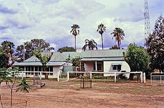
Tyson Manor is a heritage-listed site at Ruthven Street, Harlaxton, Toowoomba, Toowoomba Region, Queensland, Australia. It is also known as Strathmore. It was added to the Queensland Heritage Register on 21 August 1992. The heritage listing is currently under review.

Assembly Hall, Warwick

Assembly Hall is a heritage-listed community hall at 8 Locke Street, Warwick, Southern Downs Region, Queensland, Australia. It was added to the Queensland Heritage Register on 21 August 1992, but its heritage listing is currently under review.

Barambah Homestead

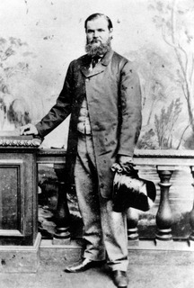
Barambah Homestead is a heritage-listed homestead at Goomeri Road, Barambah, Gympie Region, Queensland, Australia. It was designed by Frederic Herbert Faircloth and built from 1843 to 1880s circa. It was added to the Queensland Heritage Register on 21 August 1992.

Wodonga House

Wodonga House is a heritage-listed farmhouse at Woolooga Road, Widgee, Gympie Region, Queensland, Australia. It was built in 1902. It was added to the Queensland Heritage Register on 21 October 1992.

Stone Farm Building

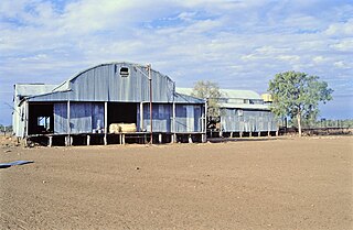
Stone Farm Building is a heritage-listed farm building at Fleurs, 739 Fleurs Lane, Clermont, Isaac Region, Queensland, Australia. It was built in 1880s. It is also known as Fleurs. It was added to the Queensland Heritage Register on 28 August 2008.

Bowen River Hotel

Bowen River Hotel is a heritage-listed hotel at Strathbowen-Leichhardt Range Road, Mount Wyatt, Whitsunday Region, Queensland, Australia. It was built c. 1865. It is also known as Heidelberg Inn. It was added to the Queensland Heritage Register on 21 October 1992.

Suttor River Causeway

Suttor River Causeway is a heritage-listed causeway across the Suttor River on the Old Bowen Downs Road, now at St Anns Road, Mount Coolon, Whitsunday Region, Queensland, Australia. It was built in 1876 by the Queensland Department of Public Works. It is also known as St Anns Crossing and Old Bowen Downs Road. It was added to the Queensland Heritage Register on 18 September 2008.

Cressbrook Cemetery

Cressbrook Cemetery is a heritage-listed cemetery off Jonsson Road, Evelyn, Tablelands Region, Queensland, Australia. It was designed by Melrose & Fenwick and built from 1913 to 1940. It is also known as Cressbrook Cemetery-Evelyn. It was added to the Queensland Heritage Register on 17 June 2003.

Gunnawarra Homestead

Gunnawarra Homestead is a heritage-listed homestead at Gunnawarra Road, Gunnawarra, Tablelands Region, Queensland, Australia. It was built from 1878 to 1908. It was added to the Queensland Heritage Register on 21 October 1992.

Eureka Hotel

Eureka Hotel is a heritage-listed hotel at Hervey Range Road, Hervey Range, Charters Towers Region, Queensland, Australia. It was built c. 1865. It was added to the Queensland Heritage Register on 21 October 1992.

Joseph Morris Mine mine in Australia

Joseph Morris Mine is a heritage-listed former mine at Georgetown Mining District, Gilberton, Shire of Etheridge, Queensland, Australia. It was built from 1903 to 1910. It was added to the Queensland Heritage Register on 5 April 2004.

Old Westmoreland Homestead

Old Westmoreland Homestead is a heritage-listed homestead at Westmoreland Station, Nicholson, Shire of Burke, Queensland, Australia. It was designed by Thomas Brassey McIntosh and built in c. 1882 by Thomas Brassey McIntosh. It was added to the Queensland Heritage Register on 31 July 2008.

Burrandowan Station Homestead homestead at Kingaroy Road, Durong, South Burnett Region, Queensland, Australia

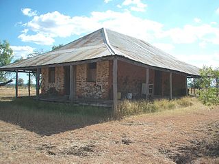
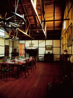
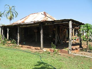
Burrandowan Station Homestead is a heritage-listed homestead at Kingaroy Road, Durong, South Burnett Region, Queensland, Australia. It was built from 1848 to c. 1927. It was added to the Queensland Heritage Register on 21 October 1992.

Mount Abundance Homestead

Mount Abundance Homestead is a heritage-listed homestead on the Warrego Highway, Bungeworgorai near Roma, Maranoa Region, Queensland, Australia. It was built from c. 1860 to 1923. It was added to the Queensland Heritage Register on 21 October 1992.

Darr River Downs

Darr River Downs is a heritage-listed homestead at Landsborough Highway, Morella, Longreach Region, Queensland, Australia. It was built from 1870s circa to 1900s circa. It was added to the Queensland Heritage Register on 27 June 2003.

Wyaga Homestead

Wyaga Homestead is a heritage-listed homestead at Millmerran Road, Wyaga near Goondiwindi, Goondiwindi Region, Queensland, Australia. It was built c. 1862. It was added to the Queensland Heritage Register on 5 May 1995.

Welford Homestead

Welford Homestead is a heritage-listed homestead in the Welford National Park, Jundah, Shire of Barcoo, Queensland, Australia. It was added to the Queensland Heritage Register on 21 August 1992.

References

  1. 1 2 "Mt Cornish Homestead (entry 600009)". Queensland Heritage Register . Queensland Heritage Council. Retrieved 1 August 2014.

Attribution

CC-BY-icon-80x15.png This Wikipedia article was originally based on "The Queensland heritage register" published by the State of Queensland under CC-BY 3.0 AU licence (accessed on 7 July 2014, archived on 8 October 2014). The geo-coordinates were originally computed from the "Queensland heritage register boundaries" published by the State of Queensland under CC-BY 3.0 AU licence (accessed on 5 September 2014, archived on 15 October 2014).

Further reading

International Standard Book Number Unique numeric book identifier

The International Standard Book Number (ISBN) is a numeric commercial book identifier which is intended to be unique. Publishers purchase ISBNs from an affiliate of the International ISBN Agency.

Commons-logo.svg Media related to Mount Cornish Homestead at Wikimedia Commons