Related Research Articles

Lambert Glacier is a major glacier in East Antarctica. At about 80 km (50 mi) wide, over 400 km (250 mi) long, and about 2,500 m (8,200 ft) deep, it is the world's largest glacier. It drains 8% of the Antarctic ice sheet to the east and south of the Prince Charles Mountains and flows northward to the Amery Ice Shelf. It flows in part of Lambert Graben and exits the continent at Prydz Bay.

The Prince Charles Mountains are a major group of mountains in Mac. Robertson Land in Antarctica, including the Athos Range, the Porthos Range, and the Aramis Range. The highest peak is Mount Menzies, with a height of 3,228 m (10,591 ft). Other prominent peaks are Mount Izabelle and Mount Stinear. These mountains, together with other scattered peaks, form an arc about 420 km (260 mi) long, extending from the vicinity of Mount Starlight in the north to Goodspeed Nunataks in the south.
The Scott Mountains are a large number of isolated peaks lying south of Amundsen Bay in Enderby Land of East Antarctica, Antarctica. Discovered on 13 January 1930 by the British Australian New Zealand Antarctic Research Expedition (BANZARE) under Sir Douglas Mawson. He named the feature Scott Range after Captain Robert Falcon Scott, Royal Navy. The term mountains is considered more appropriate because of the isolation of its individual features.

HMAS Labuan (L3501) was a Mark III Tank Landing Ship that served in the Royal Navy during World War II, and with the Royal Australian Navy (RAN) from 1946 until 1951.
Athos Range is the northernmost range in the Prince Charles Mountains of Mac. Robertson Land, Antarctica. The range consists of many individual mountains and nunataks that trend east–west for 40 miles (64 km) along the north side of Scylla Glacier.
Gilchrist Aiguilles is a series of sharp peaks close south of Mount Olsen on Laurens Peninsula, Heard Island.
The Porthos Range is the second range south in the Prince Charles Mountains of Antarctica, extending for about 30 miles in an east-to-west direction between Scylla Glacier and Charybdis Glacier. First visited in December 1956 by the Australian National Antarctic Research Expeditions (ANARE) southern party under W.G. Bewsher (1956-57) and named after Porthos, a character in Alexandre Dumas, père's novel The Three Musketeers, the most popular book read on the southern journey.
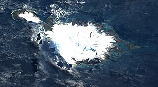
Laurens Peninsula is a rugged peninsula surmounted by several ice-covered peaks that forms the northwestern part of Heard Island in the southern Indian Ocean. The name was applied by the Australian National Antarctic Research Expedition following their survey in 1948. It derives from the existing name Cape Laurens, applied for the northwestern extremity of this peninsula after the American bark Laurens which, under Captain Franklin F. Smith, visited Heard Island in 1855–56 and assisted in initiating sealing operations there.

Downes Glacier is a broad tidewater glacier on the north side of Heard Island in the southern Indian Ocean. It flows north on both sides of Cape Bidlingmaier to the north coast of Heard Island. To the east of Downes Glacier is Ealey Glacier, whose terminus is located close southeast of Cape Bidlingmaier. To the west of Downes Glacier is Challenger Glacier, whose terminus is located at the eastern side of Corinthian Bay, close west to Saddle Point. Saddle Point separates Downes Glacier from Challenger Glacier.
Lavett Bluff is a rock bluff between Deacock Glacier and Fiftyone Glacier on the south side of Heard Island in the southern Indian Ocean. It was surveyed in 1948 by an Australian National Antarctic Research Expedition (ANARE) and named "Cape Lavett" for Lieutenant John L. Lavett, Royal Australian Navy, one of the officers on HMAS Labuan, the relief ship for the expedition. Further ANARE exploration led to revision of the name in 1964 to Lavett Bluff.
On the continent of Antarctica, the Aramis Range is the third range south in the Prince Charles Mountains, situated 11 miles southeast of the Porthos Range and extending for about 30 miles in a southwest–northeast direction. It was first visited in January 1957 by Australian National Antarctic Research Expeditions (ANARE) southern party led by W.G. Bewsher, who named it for a character in Alexandre Dumas' novel The Three Musketeers, the most popular book read on the southern journey.
Budd Pass is a mountain pass in the ridge that extends southwest from Budd Peak on Heard Island. The pass is 1 nautical mile (2 km) southwest of Budd Peak. It was surveyed by Australian National Antarctic Research Expeditions (ANARE), 1948–63, and named by the Antarctic Names Committee of Australia for G.M. Budd, ANARE officer-in-charge on Heard Island in 1954 and leader of the 1963 ANARE Heard Island expedition.
Budd Peak is a peak, 2,315 metres (7,600 ft) high, 1.7 nautical miles (3.1 km) southeast of Mawson Peak on Heard Island. The peak was mapped by Australian National Antarctic Research Expeditions (ANARE) in 1948, and named by the Antarctic Names Committee of Australia for G.M. Budd, ANARE officer-in-charge on Heard Island in 1954, and leader of the 1963 ANARE Heard Island expedition.
Campbell Peak is a peak, 2,415 metres (7,920 ft) high, standing 1.2 nautical miles (2.2 km) northeast of Mawson Peak, the summit of Heard Island. It was surveyed in 1948 by the Australian National Antarctic Research Expeditions (ANARE), who named it for Group-Captain Stuart A. Campbell, Royal Australian Air Force. Campbell visited Heard Island in 1929 as aircraft pilot with the British Australian and New Zealand Antarctic Research Expedition led by Douglas Mawson, and again as leader of ANARE when a research station was established on the island in December 1947.
Mount Olsen is a snow-covered peak standing 0.2 nautical miles (0.4 km) east of Hayter Peak on Laurens Peninsula, in the northwest part of Heard Island.
North Barrier is a narrow rock ridge which descends northward from Campbell Peak to Mount Separation, and then along the northwest flank of Compton Glacier in northern Heard Island. The descriptive name was applied by ANARE in 1948.
Mount Separation is a rocky peak, 1,480 m, standing 1 nautical mile (1.9 km) northeast of Campbell Peak on the northeast flank of Big Ben, the dominating mountain on Heard Island. Surveyed in 1948 by the ANARE and probably so named by them because this feature lies somewhat apart from the main cluster of peaks near the summit of Big Ben.
South Barrier is a rocky ridge descending southward from Budd Peak along the east margin of Fiftyone Glacier and terminating at Lambeth Bluff in southern Heard Island. The descriptive name was applied by ANARE in 1948.
Vanhoffen Bluff is a rocky bluff immediately east of Jacka Glacier on the north coast of Heard Island. It is named for Ernst Vanhöffen (1858–1918), a German zoologist, and a member of the Gauss expedition under the leadership of Erich von Drygalski (1865–1949). During its 1902 investigations of the area, Drygalski applied the name Kap Vanhoffen to a cliffed feature about 1.5 nautical miles (2.8 km) to the northwest, near The Sentinel. The ANARE, during its 1948 survey of the island, transferred the Vanhoffen name to this bluff, reporting that no well-marked cape exists along the high cliffs to the northwest.
Lambeth Bluff is a rock coastal bluff at the end of South Barrier, on the east side of Fiftyone Glacier, on the south side of Heard Island. It was surveyed in 1948 by the Australian National Antarctic Research Expeditions (ANARE) and named "Cape Lambeth" for A. James Lambeth, a geologist with the expedition. Further ANARE exploration led to revision of the name in 1964 to Lambeth Bluff.
References
- 1 2 "Dixon, Mount". Geographic Names Information System . United States Geological Survey, United States Department of the Interior . Retrieved 21 January 2012.
- ↑ "Heard: Synonyms & Subfeatures". Global Volcanism Program . Smithsonian Institution . Retrieved 27 September 2022.
![]() This article incorporates public domain material from "Dixon, Mount". Geographic Names Information System . United States Geological Survey.
This article incorporates public domain material from "Dixon, Mount". Geographic Names Information System . United States Geological Survey.
| | This subantarctic islands location article is a stub. You can help Wikipedia by expanding it. |
| | This Australia mountain, mountain range, or peak related article is a stub. You can help Wikipedia by expanding it. |