
Mount Robson is the most prominent mountain in North America's Rocky Mountain range; it is also the highest point in the Canadian Rockies. The mountain is located entirely within Mount Robson Provincial Park of British Columbia, and is part of the Rainbow Range. Mount Robson is the second highest peak entirely in British Columbia, behind Mount Waddington in the Coast Range. The south face of Mount Robson is clearly visible from the Yellowhead Highway, and is commonly photographed along this route.
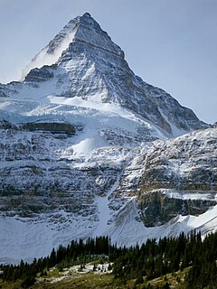
Mount Assiniboine, also known as Assiniboine Mountain, is a pyramidal peak mountain located on the Great Divide, on the British Columbia/Alberta border in Canada.
Mount Clemenceau is the fourth highest mountain in the Park Ranges of the Canadian Rockies. The peak was originally named "Pyramid" in 1892 by Arthur Coleman. The mountain was renamed by the Interprovincial Boundary Survey in 1919 to its present name, which is for Georges Clemenceau, premier of France during World War I.

Garibaldi Provincial Park, also called Garibaldi Park, is a wilderness park located on the coastal mainland of British Columbia, Canada, 70 kilometres (43.5 mi) north of Vancouver. It was established in 1920 and named a Class A Provincial Park of British Columbia in 1927. The park is a popular destination for outdoor recreation, with over 30,000 overnight campers and over 106,000 day users in the 2017/2018 season.

The Columbia Mountains are a group of mountain ranges along the upper Columbia River in British Columbia, Montana, Idaho and Washington. The mountain range covers 135,952 km². The range is bounded by the Rocky Mountain Trench on the east, and the Kootenai River on the south; their western boundary is the edge of the Interior Plateau. Seventy-five percent of the range is located in Canada and the remaining twenty-five percent in the United States; American geographic classifications place the Columbia Mountains as part of the Rocky Mountains complex, but this designation does not apply in Canada. Mount Sir Sandford is the highest mountain in the range, reaching 3,519 metres (11,545 ft).

The Rainbow Range is a small subrange of the Park Ranges subdivisions of the Northern Continental Ranges of the Rocky Mountains on the border between Alberta and British Columbia in Mount Robson Provincial Park.
The Skeena Mountains, also known as the Skeenas, are a subrange of the Interior Mountains of northern British Columbia, Canada, essentially flanking the upper basin of the Skeena River. They lie just inland from the southern end of the Boundary Ranges of the Coast Mountains, and also of the northern end of the Kitimat Ranges. Their southern limit is described by the Bulkley River and the upper northwestern reaches of Babine and Takla Lakes, and on their northeast by the upper reaches of the Omineca River.
Mount Sir Sandford is the highest mountain of the Sir Sandford Range and the highest mountain in the Selkirk Mountains of southeastern British Columbia, Canada. It is the 12th highest peak in the province. The mountain was named after Sir Sandford Fleming, a railway engineer for the Canadian Pacific Railway.
The Northern Rocky Mountains, usually referred to as the Northern Rockies, are a subdivision of the Canadian Rockies comprising the northern half of the Canadian segment of the Rocky Mountains. While their northward limit is easily defined as the Liard River, which is the northward terminus of the whole Rockies, the southward limit is debatable, although the area of Mount Ovington and Monkman Pass is mentioned in some sources, as south from there are the Continental Ranges, which are the main spine of the Rockies forming the boundary between British Columbia and Alberta. Some use the term to mean only the area north of the Peace Arm of the Williston Reservoir, and in reference to Northern Rocky Mountains Provincial Park, while others consider the term to extend all the way south, beyond the limit of the Hart Ranges at Mount Ovington, to include the McBride area, the Sir Alexander Group and Mount Robson.

Mount Arthur is a mountain located at the Queen Reach arm of the Jervis Inlet within the Pacific Ranges of the Coast Mountains in British Columbia Canada. The mountain was named during the 1860 survey by HMS Plumper who charted all of the area and named the mountain after Prince Arthur William Patrick who was the seventh son of Queen Victoria and Prince Albert of England.
Mount Helena is a mountain located at the Queen Reach arm of Jervis Inlet and behind Princess Louisa Inlet. Mount Helena is part of the Pacific Ranges of the Coast Mountains in British Columbia Canada. The mountain was named during the 1860 survey by HMS Plumper who charted all of the known area and named the mountain after Princess Helena Augusta Victoria "Lenchen" who was the fifth child of Queen Victoria and Prince Albert of England.
Powder Mountain, 2,347 m (7,700 ft), is a volcanic summit in the Powder Mountain Icefield in the Pacific Ranges of the Coast Mountains in southwestern British Columbia, Canada.
Mount Brew is a mountain located 12 km (7 mi) south of Lillooet and 44 km (27 mi) north of Skihist Mountain in south-central British Columbia, Canada. It lies on the western side of the Fraser River and is the third-highest mountain of the Lillooet Ranges, after Skihist Mountain and Petlushkwohap Mountain in the Cantilever Range to the west of Lytton.
The Cadwallader Range, originally named the Cadwallader Mountains, is a sub-range of the Pacific Ranges of the Coast Mountains in the Bridge River-Lillooet Country of the South-Central Interior of British Columbia, Canada, located between the south end of Anderson Lake (E) and the Hurley River. According to the provincial basemap, the precise alpine boundaries of the range are McGilliray Pass, at its eastern extremity and beyond which is the Bendor Range, and the pass between Noel and Sockeye Creeks on its west, which is immediately north of the lower end of Birkenhead Lake. The officially unnamed range west of that has been called the Noel Range, after its main peak Mount Noel. At the foot of the range along its northeast flank is Cadwallader Creek, scene of the historic and once-rich Bralorne and Pioneer Mines and the ghost town of Bralorne.
Mount Ulysses, is the highest mountain in the Muskwa Ranges of the Northern Canadian Rockies in British Columbia. It and neighbouring peaks are part of a group of names drawing on the epic poem The Odyssey, in which here Ulysses wanders for 10 years before being able to return home to Ithaca.
Murray Range, is a subdivision range of the Hart Ranges, of the Northern Rockies in British Columbia, Canada. The majority of the range lies within the Pine-Lemoray Provincial Park and is noted for its snowmobiling, hiking and ski touring opportunities. The boundaries of the Murray Range generally lie between the Misinchinka River to the west and Mountain Creek to the east; the Pine River to the north and Mount Reynolds to the south.
Misinchinka Ranges, is the largest subdivision range of the Hart Ranges, of the Northern Rockies in British Columbia, Canada. The boundaries of the Misinchinka Ranges generally lie between the Rocky Mountain Trench to the west, Clearwater Creek and the Sukunka River to the east, the Peace Arm of Williston Reservoir to the north and Monkman Provincial Park to the south.
Mount Crysdale, is a 2,427-metre (7,963 ft) ultra-prominent, isolated peak in the Misinchinka Ranges, a subdivision range of the Hart Ranges, within the Northern Rocky Mountains.

Mount Morfee, is a 1,775 metre peak in the Misinchinka Ranges, a subdivision range of the Hart Ranges, within the Northern Rocky Mountains. The mountain is known locally as Morfee Mountain and features prominently over the town Mackenzie, BC.


