
Rwanda is located in East Africa, to the east of the Democratic Republic of the Congo, at the co-ordinates 2°00′S30°0′E.

Butare was a province (prefecture) of Rwanda prior to its dissolution in January 2006. Butare city was the second largest city in Rwanda and one of the nation's former twelve provinces. It is located in south-central region of the country and borders Burundi to the south. It had a population of 77.449 as of January 2006.

Butare, also known as Huye and formerly known as Astrida, is a city with a population of 62,823 in the Southern Province of Rwanda and the capital of Huye district. It is the seventh largest town in Rwanda by population.
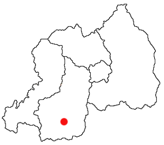
Southern Province is one of Rwanda's five provinces. It was created in early January 2006 as part of a government decentralization program that re-organized the country's local government structures.

The East African mountains are a mountain region in the African Great Lakes, within Kenya, Uganda, Tanzania, Democratic Republic of the Congo, Rwanda and Burundi.

The Albertine Rift is the western branch of the East African Rift, covering parts of Uganda, the Democratic Republic of the Congo (DRC), Rwanda, Burundi and Tanzania. It extends from the northern end of Lake Albert to the southern end of Lake Tanganyika. The geographical term includes the valley and the surrounding mountains.
The five provinces of Rwanda are divided into 30 districts. Each district is in turn divided into sectors, which are in turn divided into cells, which are in turn divided into villages.

Maraba coffee is grown in the Maraba area of southern Rwanda. Maraba's coffee plants are the Bourbon variety of the Coffea arabica species and are grown on fertile volcanic soils on high-altitude hills. The fruit is handpicked, mostly during the rainy season between March and May, and brought to a washing station in Maraba, where the coffee beans are extracted and dried. At several stages, the beans are sorted according to quality. The farmers receive credits based on the amount and quality of the beans they provide.
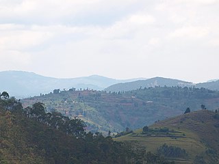
Maraba is a region in southern Rwanda. It used to be a district in the Butare Province before a government decentralization programme that re-organized the country's administrative divisions in 2006. It is now a sector of the Huye District in the Southern Province. The closest major city is Butare.

Mukura Victory Sports et Loisirs Football Club, commonly known as Mukura Victory Sports or simply Mukura, is an association football club from Butare, Rwanda. Founded in May 1963, the club currently competes in the Rwanda Premier League and plays its home games at Stade Huye.

The Huye Stadium is a multi-use stadium in Butare, Rwanda. It is currently used mostly for football matches and is the home ground of Mukura Victory Sports FC. The stadium holds 10,000 people.

Huye is one of the eight districts (Akarere) that make up Rwanda's Southern Province. It has a total surface area of 581.6 square Kilometers. It has thirteen sectors and 77 cells with a total of 508 umudugudus (villages) in total. The district has a population of 381,900, with an average of 660 inhabitants per square kilometer. The largest city in the province is Butare.

Muhanga is a district (akarere) in Rwanda. It is found in southern province and its administrative centre is located in the city of Muhanga.

Nyabihu is a district (akarere) in Western Province, Rwanda. Its capital is Mukamira. Nyabihu district is divided into 12 sectors (imirenge): Bigogwe, Jenda, Jomba, Kabatwa, Karago, Kintobo, Mukamira, Muringa, Rambura, Rugera, Rurembo and Shyira.These sectors are themselves separated in 73 cells and 474 villages also called “imidugudu".
These are some of the articles related to Rwanda on the English Wikipedia pages:
Butare Airport is an airport in Butare, Rwanda.
The Saint Charles Borromeo Major Seminary of Nyakibanda is a Roman Catholic seminary near to Butare, in the Gishamvu sector of the Huye District in Southern Province of Rwanda, below the mountain chain called "Ibisi bya Nyakibanda". It is about 12 kilometres (7.5 mi) from Butare.
Sovu is a village in the Huye District of the Southern Province in Rwanda. The village is home to one of four coffee washing stations belonging to the Maraba coffee cooperative, Abahuzamugambi ba kawa, used by around 400 of the cooperatives farmers.
The Kigoma–Butare–Ngozi–Gitega High Voltage Power Line, also Rwanda–Burundi High Voltage Power Line is a high voltage electricity power line, under construction, connecting the high voltage substation at Kigoma in Rwanda to another high voltage substation at Gitega in Burundi.
