
Jefferson is a town in Coos County, New Hampshire, United States. The population was 1,107 at the 2010 census. It is home to parts of the White Mountain National Forest in the south and northeast and to Santa's Village, a Christmas-themed amusement park. There are also several private campgrounds, motels and inns.
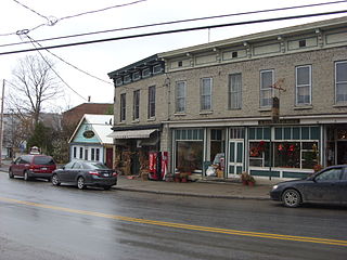
Cherry Valley is a town in Otsego County, New York, United States. The population was 1,224 at the 2010 census.

Owens Valley is the now-arid valley of the Owens River in eastern California in the United States, to the east of the Sierra Nevada and west of the White Mountains and Inyo Mountains on the west edge of the Great Basin. The mountain peaks on either side reach above 14,000 feet (4,300 m) in elevation, while the floor of the Owens Valley is about 4,000 feet (1,200 m), making the valley the deepest in the United States. The Sierra Nevada casts the valley in a rain shadow, which makes Owens Valley "the Land of Little Rain." The bed of Owens Lake, now a predominantly dry endorheic alkali flat, sits on the southern end of the valley.

The Anti-Lebanon Mountains are a southwest-northeast-trending mountain range that forms most of the border between Syria and Lebanon. The border is largely defined along the crest of the range. Most of the range lies in Syria.

The Taconic Mountains or Taconic Range are a range of the Appalachian Mountains, running along the eastern border of New York State and adjacent New England from northwest Connecticut to western Massachusetts, north to central western Vermont. A physiographic region of the larger New England province, the range includes notable summits, including its high point, 3,840 feet (1,170 m) Mount Equinox In Vermont, and 3,489 feet (1,063 m) Mount Greylock, the highest point in Massachusetts.

Northeastern Pennsylvania (NEPA) is a geographic region of the U.S. state of Pennsylvania that includes the Pocono Mountains, the Endless Mountains, and the industrial cities of Scranton, Wilkes-Barre, Pittston, Hazleton, Nanticoke, and Carbondale. A portion of this region constitutes a part of the New York City metropolitan area.

The Johns River, in northern New Hampshire, arises at Cherry Pond in Jefferson and runs approximately 14 miles (23 km), generally northwest, to the Connecticut River. It passes through Hazens Pond, near the Mount Washington Regional Airport, traverses the town of Whitefield, where it is crossed by U.S. Highway 3, and then crosses the town of Dalton before joining the Connecticut. It is named for an early hunter and trapper of the area, John Glines, who established a fishing and hunting camp in the area in the 18th century. Another nearby river, the Israel River, is named for John's brother Israel.

Mount York, a mountain in the western region of the Explorer Range, part of the Blue Mountains Range that is a spur off the Great Dividing Range, is located approximately 150 kilometres (93 mi) west of Sydney, just outside Mount Victoria in New South Wales, Australia. Mount York has an elevation of 1,061 metres (3,481 ft) AHD and is a projection of the Blue Mountains dissected plateau, creating a promontory of the western escarpment with a minor rise at its summit.

Halcott Mountain is one of the Catskill Mountains of the U.S. state of New York. It is mostly located in Greene County, with some of its lower slopes in Delaware and Ulster counties. Its exact summit elevation has not been officially determined, but the highest contour line on the mountain is 3,520 feet (1,070 m). It is one of the peaks on the divide between the Delaware and Hudson watersheds.
Mount Sherrill is a mountain located in Greene County, New York, and is named after Eliakim Sherrill, and is part of the Catskill Mountains. Mount Sherrill is flanked to the east by North Dome, and to the west by Balsam Mountain.

Ski country is the hilly, snowy portions of the boundary between the Niagara Frontier and the Southern Tier of the western part of New York.
Mount Raimer, 2,572 feet (784 m), is a prominent peak in the Taconic Mountains of western Massachusetts and adjacent New York. The west side and summit are located in New York; the east slopes lie within Massachusetts. The summit ridge is part meadow and part wooded with red spruce, balsam fir, and northern hardwood tree species. It is notable for its views of the Hoosic River valley and Hudson River Valley. The 35 mi (56 km) Taconic Crest Trail traverses the mountain. Much of the upper slopes and summit are within protected conservation land. The mountain is the location of a defunct ski area.

Brace Mountain is the peak of a ridge in the southern Taconic Mountains, near the tripoint of the U.S. states of New York, Connecticut and Massachusetts. Its 2,311-foot (704 m) main summit is located in New York; it is the highest point in that state's Dutchess County.

Alander Mountain, 2,239 feet (682 m), is a prominent peak of the south Taconic Mountains; it is located in southwest Massachusetts and adjacent New York. Part of the summit is grassy and open and part is covered with scrub oak and shrubs; the sides of the mountain are wooded with northern hardwood tree species. Views from the top include the southern Taconic Mountains, the Hudson River Valley including the Catskills. Several trails traverse Alander Mountain, most notably the 15.7 mi (25.3 km) South Taconic Trail, which passes just beneath the summit.
White Rock, 2,550 feet (780 m), is the high point on a 7 mi (11 km) ridgeline in the Taconic Mountains. The ridge is located in the tri-state corner of New York, Massachusetts, and Vermont in the towns of Petersburgh, Williamstown, and Pownal. The ridge has several distinct knobs; those with names are, from south to north: White Rocks, 2,365 feet (721 m); Smith Hill, 2,330 feet (710 m); White Rock, the high point 2,550 feet (780 m); and Bald Mountain 2,485 feet (757 m). The Snow Hole, located along the ridgeline between Bald Mountain and the White Rock, is a crevasse in which snow can be found well into the summer.

The Marcy Group is a subset of the Great Range of the Adirondack Mountains, near Keene Valley, New York, United States. It consists of the High Peaks near Mount Marcy at the southern end of the Great Range, Allen Mountain, Cliff Mountain, Mount Colden, Gray Peak, Mount Haystack, Mount Redfield, and Mount Skylight, and the lesser peaks McDonnel Mountain, North River Mountains Peak, and Rist Mountain.

Shankley Mountain is a mountain in the Central New York region of New York. It is located northwest of Cherry Valley, New York.
Cape Wykoff is a mountain in the Central New York region of New York. It is located northwest of Cherry Valley, New York.


