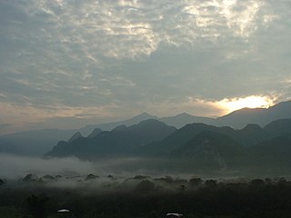
Mount Tahan, is the highest point in Peninsular Malaysia with an elevation of 7,175 ft (2,187 m) above sea level, on the border between the states of Pahang and Kelantan, with the peak lies on the Pahangese side. It is part of the Taman Negara that straddles Jerantut District in Pahang, Gua Musang District in Kelantan and Hulu Terengganu District in Terengganu. The mountain is part of the Tahan Range in the Tenasserim Hills and is popular with local climbers.

Terengganu, formerly spelled Trengganu or Tringganu, is a sultanate and federal state of Malaysia. The state is also known by its Arabic honorific, Dāru l-Īmān. The coastal city of Kuala Terengganu, which stands at the mouth of the broad Terengganu River, is both the state and royal capital as well as the largest city in Terengganu. Other major cities and towns includes Jerteh, Kuala Dungun, Chukai, Kuala Berang, Marang, and Permaisuri. At 13,035 square kilometres in size and a population of around 1.14 million people, Terengganu is Malaysia's 7th largest state by area and 10th largest in population. Terengganu, along with Kelantan, Perlis and the Federal Territory of Putrajaya is one of the most homogeneous states/territories in the country of which 95% of the population are ethnic Malay-Muslims with its own distinct language/dialect, culture, history and tradition.

Taman Negara is a national park in Peninsular Malaysia. It was established in 1938/1939 as the King George V National Park after Theodore Hubback lobbied the sultans of Pahang, Terengganu and Kelantan to set aside a piece of land that covers the three states for the creation of a protected area. It was renamed Taman Negara after independence, which means "national park" in Malay. Taman Negara has a total area of 4,343 km2 and it is one of the world's oldest deciduous rainforests, estimated to be more than 130 million years old.
The Titiwangsa Mountains, also known as Banjaran Besar by locals, is the chain of mountains that forms the backbone of the Malay Peninsula. The northern section of the range is in southern Thailand, where it is known as Sankalakhiri Range.

Mount Jerai, formerly Kedah Peak, is a mountain in Kedah, Malaysia with the height of 3,993 feet (1,217 m). Within Kedah itself, the mountain stands at the border of Kuala Muda and Yan districts.

Mount Pulai is a mountain located in the district of Kulai, Johor, Malaysia.

Besut is a district in Terengganu, Malaysia. It is bordered by the state of Kelantan to the north and west and the South China Sea to the east. It is the northern gateway to Terengganu. Kampung Raja is the district capital, though Jerteh is more developed. Another major town is the fishing port of Kuala Besut. There are other small towns and villages such as Jabi, Apal, Pasir Akar and Tembila.

Mount Lambak is an inselberg in Kluang District, Johor, Malaysia. The summit is 510 m above sea level.

Tourism in Malaysia is a major industry and contributor to the Malaysian economy.

Mount Belumut, or known locally as Gunung Lumut, standing at 1,010 metres (3,314 ft), is a mountain located in Mount Belumut Recreational Forest in Kluang District, Johor, Malaysia, located within a massif north of Linggiu Reservoir. It is the third tallest peak in Johor.

Mount Pueh, also known as Mount Pueh-Berumput, Mount Poi and Mount Poe, is a mountain located near Lundu, Sarawak on the Malaysia-Indonesia border. Mount Pueh was known to biologists for the collections made there by Eric Mjöberg (1882–1938), a Swedish naturalist, who was Curator of the Sarawak Museum between 1922 and 1924. Mjöberg's herpetological collections from Gunung Pueh between October and December 1923, and other localities in Borneo, were reported by Smith (1925). Mjöberg, unfortunately, left little by way of written records, of his ascent of Pueh and the collections he made.

Mount Ledang is a mountain located in Tangkak District, Johor, Malaysia. The summit is located next to the tripoint of Tangkak, Jasin and Tampin Districts, respectively located in the states of Johor, Malacca and Negeri Sembilan. Standing at 1,276 m (4,186 ft), it is the 64th highest mountain in Malaysia and the highest peak in Johor.
A ribu is a mountain that reaches a topographic prominence of at least 1,000 metres (3,281 ft). "Ribu" is a Malay and Indonesian word meaning "thousand".

Mount Yong Belar is a mountain on the border of the states Kelantan and Perak in the Titiwangsa Mountains of Malaysia. Its summit is 2,181 m (7,156 ft) above sea level, making it the highest mountain in the state of Kelantan, and the third highest in Peninsular Malaysia, behind Mounts Tahan and Korbu, the latter being located 8 km north.
Mount Benum or Mount Benom is a mountain in the state of Pahang in Malaysia. Its summit is 2,107 m (6,913 ft) above sea level. The mountain is located in a centre of a massif east of the Titiwangsa Mountains.

Cnemaspis argus, also known commonly as the Argus gecko, the Argus rock gecko, Dring's gecko, and the Lawit Mountain rock gecko, is a species of lizard in the family Gekkonidae. The species is endemic to Peninsular Malaysia.

Mount Angsi is a mountain which is located between the border between Ulu Bendul, Kuala Pilah District and Senawang, Seremban District in Negeri Sembilan, Malaysia. Part of the Titiwangsa Mountains, it is the seventh tallest mountain in the state, behind Mts. Besar Hantu, Hantu Kecil, Telapak Buruk, Berembun and Datuk, with an elevation of 2,707 feet (825 m).