Mountaineering, mountain climbing, or alpinism is a set of outdoor activities that involves ascending mountains. Mountaineering-related activities include traditional outdoor climbing, skiing, and traversing via ferratas that have become sports in their own right. Indoor climbing, sport climbing, and bouldering are also considered variants of mountaineering by some, but are part of a wide group of mountain sports.

Mount Everest, is Earth's highest mountain above sea level, located in the Mahalangur Himal sub-range of the Himalayas. The China–Nepal border runs across its summit point. Its elevation of 8,848.86 m was most recently established in 2020 by the Chinese and Nepali authorities.

Longs Peak is a high and prominent mountain in the northern Front Range of the Rocky Mountains of North America. The 14,259-foot (4346 m) fourteener is located in the Rocky Mountain National Park Wilderness, 9.6 miles (15.5 km) southwest by south of the Town of Estes Park, Colorado, United States. Longs Peak is the northernmost fourteener in the Rocky Mountains of Colorado and the highest point in Boulder County and Rocky Mountain National Park. The mountain was named in honor of explorer Stephen Harriman Long and is featured on the Colorado state quarter.

Mount Waddington, once known as Mystery Mountain, is the highest peak in the Coast Mountains of British Columbia, Canada. Although it is lower than Mount Fairweather and Mount Quincy Adams, which straddle the United States border between Alaska and British Columbia, Mount Waddington is the highest peak that lies entirely within British Columbia. It and the subrange which surround it, known as the Waddington Range, stand at the heart of the Pacific Ranges, a remote and extremely rugged set of mountains and river valleys.

Scrambling is a mountaineering term for ascending steep terrain using one's hands to assist in holds and balance. It is also used to describe terrain that falls between hiking and rock climbing.

Reinhold Andreas Messner is an Italian climber, explorer, and author from South Tyrol. He made the first solo ascent of Mount Everest and, along with Peter Habeler, the first ascent of Everest without supplemental oxygen. He was the first person to climb all 14 eight-thousanders, doing so without supplementary oxygen. Messner was the first to cross Antarctica and Greenland with neither snowmobiles nor dog sleds and also crossed the Gobi Desert alone. He is widely considered to be the greatest mountaineer of all time.
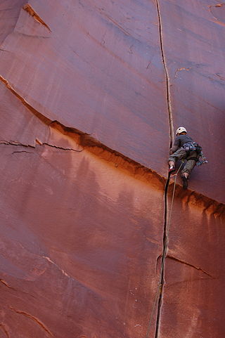
Rock climbing is a sport in which participants climb up, across, or down natural rock formations or indoor climbing walls. The goal is to reach the summit of a formation or the endpoint of a usually pre-defined route without falling. Rock climbing is a physically and mentally demanding sport, one that often tests a climber's strength, endurance, agility and balance along with mental control. Knowledge of proper climbing techniques and the use of specialized climbing equipment is crucial for the safe completion of routes.
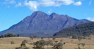
Mount Barney is a mountain within the Scenic Rim Region in south-east Queensland, Australia. It lies approximately 130 kilometres (81 mi) south-west of Brisbane, not far from the Queensland - New South Wales border, and forms part of the McPherson Range. It is a popular destination for bushwalkers and campers. Mount Barney is the sixth or seventh highest mountain in Queensland and is often regarded as one of the most impressive parts of the Scenic Rim. The mountain consists of two main peaks,, and smaller subsidiary peaks. East Peak is probably the most popular destination for bushwalkers.

Mount Arapiles is a rock formation that rises about 140 metres (460 ft) above the Wimmera plains in western Victoria, Australia. It is located in Arapiles approximately 10 kilometres (6.2 mi) west of the town of Natimuk and is part of the Mount Arapiles-Tooan State Park. Arapiles is a very popular destination for rock climbers due to the quantity and quality of climbs. It is one of the premier climbing sites in Australia along with the nearby Grampians. The Wotjobaluk name for the formation is Djurid.

Mount Asgard is a twin peaked mountain with two flat-topped, cylindrical, rock towers, separated by a saddle. It is located in Auyuittuq National Park, on the Cumberland Peninsula of Baffin Island, Nunavut, Canada. The peak is named after Asgard, the realm of the Æsir (gods) in Norse mythology. Mount Asgard is perhaps the most famous of the Baffin Mountains.

North Palisade is the third-highest mountain in the Sierra Nevada range of California, and one of the state's small number of peaks over 14,000 feet, known as fourteeners. It is the highest peak of the Palisades group of peaks in the central part of the Sierra range. It sports a small glacier and several highly prized rock climbing routes on its northeast side.

The Seven Second Summits are the second-highest mountains of each of the seven continents. All of these mountains are separate peaks rather than a sub-peak of the continents' high point. The Seven Second Summits are considered a harder challenge than the traditional Seven Summits.

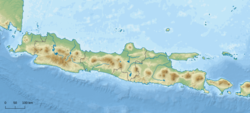
Mount Salak is an eroded volcano in West Java, Indonesia. It has several satellite cones on its southeast flank and the northern foot, along with two additional craters at the summit. Mount Salak has been evaluated for geothermal power development. According to a popular belief, the name "Salak" is derived from salak, a tropical fruit with scaly skin; however, according to Sundanese tradition, the name was derived from the Sanskrit word Salaka which means "silver". Mount Salak can be translated to "Silver Mountain" or "Mount Silver".

Mount Belumut, or known locally as Gunung Lumut, standing at 1,010 metres (3,314 ft), is a mountain located in Mount Belumut Recreational Forest in Kluang District, Johor, Malaysia, located within a massif north of Linggiu Reservoir. It is the third tallest peak in Johor.

Mount Tanigawa is a 1,977 m (6,486 ft) mountain on the border of Gunma Prefecture and Niigata Prefecture in Japan. It is one of the 100 famous mountains in Japan.

The Ellmauer Halt (2,344 m) is the highest peak in the mountain massif of the Wilder Kaiser in the Kaiser range in the Austrian state of Tyrol. To the east is the summit of the Kapuzenturm, a striking and isolated rock pinnacle. In 1883 the first summit cross was erected on the mountain top.

Puncak Jaya or Carstensz Pyramid on the island of New Guinea, with an elevation of 4,884 m (16,024 ft), is the highest mountain peak of an island on Earth, the highest peak in Indonesia, and the 8th highest mountain in Southeast Asia, on account of Indonesia being part of Asia. The mountain is located in the Sudirman Range of the highlands of Mimika Regency, Central Papua, Indonesia. Puncak Jaya is ranked 5th by topographic isolation.
Poke-O-Moonshine Mountain, spelled Pokamoonshine on U.S. Geological Survey maps, and sometimes known as just Poke-O, is a minor peak of the Adirondack Mountains. The name is believed to be a corruption of the Algonquin words pohqui, meaning 'broken', and moosie, meaning 'smooth'. It is located in the town of Chesterfield, New York, United States, on New York state Forest Preserve land, part of the Taylor Pond Wild Forest complex within the Adirondack Park. Due to its location next to the pass through which most travelers from the north enter the range, it has been called the "gateway to the Adirondacks".

Citatah Cliff is a row of cliffs located in Citatah, West Bandung regency, West Java, Indonesia. Its exact location is at 5 km Padalarang. With the morphology of hilly area and formed largely of limestone, Citatah looks different from other hills in general.