Hino is a district located in Tottori Prefecture, Japan.

Chōnan is a town located in Chiba Prefecture, Japan.
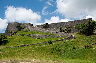
Katsuren Castle is a Ryukyuan gusuku in Uruma, Okinawa. It is a UNESCO World Heritage Site.

Hiba-Dogo-Taishaku Quasi-National Park is a Quasi-National Park that spans areas of Tottori Prefecture, Shimane Prefecture, and Hiroshima Prefecture, to the east of the island of Honshu, Japan. It was founded on 24 July 1963 and has an area of 78.08 square kilometres (78,080,000 m2). As its name suggests, the Hiba-Dogo-Taishaku Quasi-National Park is composed of a series of mountains and ravines in the middle of the Chūgoku Mountains. The park has virgin forests of Japanese beeches, Japanese oaks, Japanese horse-chestnuts and interesting ferns. Fauna include the Asiatic black bear, Japanese macaque, mountain hawk eagle and the Japanese giant salamander. Lake Shinryū is also a component of the park.

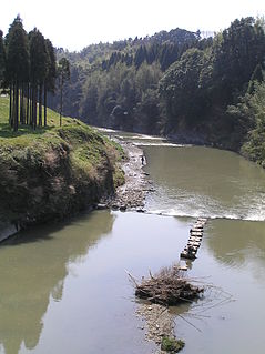
The Hino River is a major river in the western part of Tottori Prefecture. The river flows east-northeast for 77 kilometres (48 mi), and is the longest river in the prefecture. The Hino River emerges from the Chūgoku Mountains. The source of the river is at an elevation of 1,004 metres (3,294 ft) in an area near Mount Mikuni and Mount Dōgo in Nichinan in southeastern Tottori Prefecture. At Kofu, the river turns north-northwest. The lower part of the Hino River flows through the Yonago Plain before finally discharging into Miho Bay at Hiezu near Yonago. Erosion over time has created the scenic Sekkakei Ravine. The Sukesawa Dam forms an artificial lake, Lake Nichinan. Approximately 60,800 people use the water provided by the Hino River.

Ishibutai Kofun (石舞台古墳) is a stone kofun tumulus of the Asuka period in the east of Shimanoshō, Asuka, Nara Prefecture, Japan. The kofun is believed to be the tomb of Soga no Umako. It occupies a space of 54 m (177 ft), and is the largest known megalithic structure in Japan. The kofun is also known as the Ishibutoya (石太屋) Kofun.

Akaiwa is a city located in Okayama Prefecture, Japan.

Yuigahama (由比ヶ浜海岸) is a beach near Kamakura, a city in Kanagawa Prefecture, Japan. The relation between the beach and its neighboring areas is complex. Although Yuigahama is legally the entire 3.2 km beach that goes from Inamuragasaki, which separates it from Shichirigahama, to Zaimokuza's Iijima cape, which separates it from Kotsubo and the Miura Peninsula, the name is customarily used to indicate the portion west of the Namerigawa river, while the eastern half is called Zaimokuza Beach (材木座海岸). This is the reason why, although the beach gives its name to only the west part of the beachside community, traces of the name Yuigahama can be found also in Zaimokuza. The center of Yuigahama came legally into being between 1964 and 1965 and was named after the beach. Today's Yuigahama was until then divided between Zaimokuza, Ōmachi, and Hase.

Mitsuishi River is a river in Hokkaidō, Japan. It is 31.6 kilometers (19.6 mi) in length and has a drainage area of 159.4 square kilometers (61.5 sq mi).
Kasamori-ji (笠森寺) is a Buddhist temple located in the town of Chōnan in Chiba Prefecture, Japan. The temple is also called "Kasamori-dera" using the alternate pronunciation of the Chinese character for temple (tera). Kasamori-ji is temple number 31 in the Bandō Sanjūsankasho, or the circuit of 33 Buddhist temples in Eastern Japan sacred to Goddess Kannon. The Eleven-Faced Kannon of Kasamori-ji is only shown to the public in the years of the Ox and Horse in the 12-year cycle of the Chinese zodiac.

Enpuku-ji (円福寺) is a Buddhist temple located in the city of Chōshi in Chiba Prefecture. According to tradition, the temple was founded by Kūkai between 810 and 824 AD, and possibly sits on the site of a former temple called Iinuma-ji. According to tradition, in this period Kūkai built a dōu (堂宇) main hall and conducted services at the temple. Enpuku-ji is the 27th station on the Bandō Sanjūsankasho circuit of temples in Eastern Japan, sacred to Goddess Kannon. The majority of buildings in the temple complex were destroyed during the aerial bombing of Chōshi in World War II.

Kiyomizu-dera (清水寺) is a Buddhist temple located in the city of Isumi in Chiba Prefecture, Japan. According to an alternate reading of the name in Japanese, the temple is also referred to as Seisui-ji, and is commonly known as the Kiyomizu Kannon. Kiyomizu-dera is the 32nd temple in the Bandō Sanjūsankasho, or the circuit of 33 Buddhist temples in Eastern Japan sacred to bodhisattva Kannon.
The Isumi River is a river in Chiba Prefecture, Japan. It is 68 kilometers (42 mi) in length and has a drainage area of 299 square kilometers (115 sq mi). Under the Rivers Act of 1906 the Isumi is designated as a Class 2 River. Additionally, the government has designated the Isumi River a national-level Natural Monument.

The Yōrō River is a river in Chiba Prefecture, Japan. It is 73.4 kilometers (45.6 mi) in length and has a drainage area of 260 square kilometers (100 sq mi). Under the Rivers Act of 1906 the Yōrō is designated as a Class 2 River. The Yōrō originates near Mount Kiyosumi on the border of Amatsukominato area of Kamogawa and Ōtaki, and then passes through Ōtaki and Ichihara. The Yōrō Ravine and Awamata Falls are located in the upper part of the Yōrō, and it meets the Koshikiya River, the Heizō River, and the Uchida River at its midpoint. Land around the middle and lower parts of the Yōrō have been developed for rice production. The river flows through significant parts of the Bōsō Hill Range before it empties into Tokyo Bay in the Goi and Iwazaki districts of Ichihara. Land reclamation at the mouth of the Yōrō is a component of the Keiyō Industrial Zone. The Kominato Line of the Kominato Railway roughly follows the path of the Yōrō and provides access to many of the tourist destinations along the river, including mountains, waterfalls, and an onsen hot spring.
The Ichinomiya River is a river in Chiba Prefecture, Japan. It is 37.3 kilometers (23.2 mi) in length and has a drainage area of 222 square kilometers (86 sq mi). Under the Rivers Act of 1906 the Ichinomiya is designated as a Class 2 River. The river basin of the Ichinomiya was a social, cultural, and economic center of Kazusa Province in pre-modern Japan. Although very shallow, the river was used to transport sardines from Kujukuri Beach to Tokyo Bay until the beginning of the Meiji period.

The Koito River is a river in Futtsu and Kimitsu, Chiba Prefecture, Japan. The river is 82 kilometers (51 mi) in length and has a drainage area of 148.7 square kilometers (57.4 sq mi). The Koito is the third-longest river in Chiba Prefecture, and under the Rivers Act of 1906 the Koito is designated as a Class 2 River. The name of the river in Japanese is a combination of two kanji characters, the first meaning “little”, and the second meaning “thread”.

Nihon-ji is a Buddhist temple in the city of Kyonan, Chiba Prefecture, Japan. The temple is located on the slopes of Mount Nokogiri and is known for its Nihon-ji Daibutsu. Nihon-ji was established as a Hossō sect temple, was transferred to the Tendai sect, and is now a Sōtō Zen temple. Since its founding the temple has fallen into ruin and been revived numerous times.

The Hanami River is a river in Yachiyo and Chiba, Chiba Prefecture, Japan. The river is 18.9 kilometers (11.7 mi) in length and has a drainage area of 94.5 square kilometers (36.5 sq mi). The Hanami is one part of the Inba Discharge Channel. The upper part of the drainage facility is designated as the Shin River. The lower part, the Hanami, ranges from the Ōwada Drainage Pump Station in Yachiyo City, and drains into Tokyo Bay in the Mihama Ward of Chiba City. The lower part of the river where the Hanami empties into Tokyo Bay is known as the Kemi River. Numerous sluices have been built on the Hanami to protect the surrounding area from damage due to high tides and typhoons.

Mount Yonaha, also known as Mount Yunaha, is a mountain located in Kunigami on the main island of Okinawa in Okinawa Prefecture. The mountain has an elevation of 503 m (1,650 ft), but Yonaha-dake triangulation station is located at the next peak of elevation of 498 m (1,634 ft).