Mount Sisu

Last updated
Location of Sentinel Range in Western Antarctica. Sentinel-Range-location-map.png
Location of Sentinel Range in Western Antarctica.
Sentinel Range map. Vinson-Map.jpg
Sentinel Range map.

Mount Sisu is a mountain in the Antarctic. Finnish mountaineers Veikka Gustafsson and Patrick Degerman were the first people to ascend it, in 1997. It was named after the Finnish concept of sisu , meaning a sense of steadfast, rugged perseverance. The name has not been officially sanctioned by the United States Geological Survey, as it is not found on their Geographic Names Information System, [1] nor does it meet the organization's standards for geological nomenclature on the Antarctic continent. [1]

Mountain A large landform that rises fairly steeply above the surrounding land over a limited area

A mountain is a large landform that rises above the surrounding land in a limited area, usually in the form of a peak. A mountain is generally steeper than a hill. Mountains are formed through tectonic forces or volcanism. These forces can locally raise the surface of the earth. Mountains erode slowly through the action of rivers, weather conditions, and glaciers. A few mountains are isolated summits, but most occur in huge mountain ranges.

Antarctic region around the Earths South Pole

The Antarctic is a polar region around the Earth's South Pole, opposite the Arctic region around the North Pole. The Antarctic comprises the continent of Antarctica, the Kerguelen Plateau and other island territories located on the Antarctic Plate or south of the Antarctic Convergence. The Antarctic region includes the ice shelves, waters, and all the island territories in the Southern Ocean situated south of the Antarctic Convergence, a zone approximately 32 to 48 km wide varying in latitude seasonally. The region covers some 20 percent of the Southern Hemisphere, of which 5.5 percent is the surface area of the Antarctic continent itself. All of the land and ice shelves south of 60°S latitude are administered under the Antarctic Treaty System. Biogeographically, the Antarctic ecozone is one of eight ecozones of the Earth's land surface.

Eero Veikka Juhani Gustafsson, known as Veikka Gustafsson is a Finnish mountaineer who has ascended all 14 eight-thousanders in the world without the use of supplemental oxygen. He is also known for presenting a TV Travel Show on Finnish Television. In 1993 Gustafsson became the first Finnish person to have reached the top of Mount Everest. In the spring of 1997, he also became the first Finn to have reached the summit without the use of bottled oxygen.

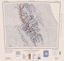
Mount Sisu, reaching a height of 4300 meters over sea level, is located in the Sentinel Range of the Ellsworth Mountains, also the site of the highest peak in the Antarctic, the Vinson Massif. The nearest other peaks to Mount Sisu are Mount Anderson and Mount Bentley. [2]

Sentinel Range mountain range in Antarctica, northward of Minnesota Glacier, forms the northern half of the Ellsworth Mountains

The Sentinel Range is a major mountain range situated northward of Minnesota Glacier and forming the northern half of the Ellsworth Mountains in Antarctica. The range trends NNW-SSE for about 185 km (115 mi) and is 24 to 48 km wide. Many peaks rise over 4,000 m (13,100 ft) and Vinson Massif (4892 m) in the southern part of the range is the highest elevation on the continent.

Ellsworth Mountains highest mountain ranges in Antarctica

The Ellsworth Mountains are the highest mountain ranges in Antarctica, forming a 360 km (224 mi) long and 48 km (30 mi) wide chain of mountains in a north to south configuration on the western margin of the Ronne Ice Shelf in Marie Byrd Land. They are bisected by Minnesota Glacier to form the Sentinel Range to the north and the Heritage Range to the south. The former is by far the higher and more spectacular with Mount Vinson (4,892 m) constituting the highest point on the continent. Geologically, they are part of the Antarctandes which stretch from the Antarctic Peninsula to Cape Adare on the western shore of the Ross Sea. The Antarctandes form the southernmost arc of the Pacific 'Ring of Fire'. The mountains are located within the Chilean Antarctic territorial claim but outside of the Argentinian and British ones.

Vinson Massif massif containing the highest peak in Antarctica

Vinson Massif is a large mountain massif in Antarctica that is 21 km (13 mi) long and 13 km (8.1 mi) wide and lies within the Sentinel Range of the Ellsworth Mountains. It overlooks the Ronne Ice Shelf near the base of the Antarctic Peninsula. The massif is located about 1,200 kilometres (750 mi) from the South Pole. Vinson Massif was discovered in January 1958 by U.S. Navy aircraft. In 1961, the Vinson Massif was named by the Advisory Committee on Antarctic Names (US-ACAN), after Carl G. Vinson, United States congressman from the state of Georgia, for his support for Antarctic exploration. On November 1, 2006, US-ACAN declared Mount Vinson and Vinson Massif to be separate entities.

Maps

Related Research Articles

Mount Anderson (Antarctica) mountain in Antarctica

Mount Anderson is a high mountain in the northern part of the Sentinel Range in Ellsworth Mountains, Antarctica. Probuda Ridge is trending northeast of the peak, and Embree Glacier and Ellen Glacier's tributary Fonfon Glacier drain its northeastern and eastern slopes respectively. It is part of the same massif as Mount Bentley and Mount Sisu.

Mount Press

Mount Press is a peak rising to 3,830 m in the north-central Sentinel Range in Ellsworth Mountains, Antarctica. It is linked to Eyer Peak by Zvegor Saddle, and surmounts Embree Glacier to the north and Ellen Glacier to the southeast. Mount Press is the summit of Probuda Ridge, and was first ascended by the American Jed Brown and the Chileans Camilo Rada and Maria Paz 'Pachi' Ibarra on 31 December 2006.

Craddock Massif

Craddock Massif is a mountain massif in the Sentinel Range of the Ellsworth Mountains, in the Chilean claim of West Antarctica.

Gildea Glacier glacier in Antarctica

Gildea Glacier is a glacier 10 kilometres (6 mi) long and 5 kilometres (3 mi) wide flowing southwestward from Craddock Massif between Mount Slaughter and Mount Atkinson into Nimitz Glacier, in the Sentinel Range of the Ellsworth Mountains, Antarctica. The upper portion of the glacier also receives ice from Hammer Col and southern Vinson Massif.

Príncipe de Asturias Peak

Príncipe de Asturias Peak is the peak rising to 4680 m in Vinson Massif, Sentinel Range in Ellsworth Mountains, Antarctica, and surmounting Branscomb Glacier to the west-northwest, Roché Glacier to the north and Tulaczyk Glacier to the southwest.

Galicia Peak

Galicia Point is the peak rising to 4500 m in Vinson Massif, Sentinel Range in Ellsworth Mountains, Antarctica, and surmounting Jacobsen Valley to the east and Branscomb Glacier to the north and west.

Roché Glacier glacier in Antarctica

Roché Glacier is the 5.8 km long and 2 km wide glacier draining the central part of Vinson Plateau in Sentinel Range, Ellsworth Mountains in Antarctica. Its head is bounded by Mount Vinson to the north, Corbet Peak and Clinch Peak to the east, Wahlstrom Peak to the southeast, and Hollister Peak to the south, with the glacier flowing westwards and descending steeply north of Silverstein Peak to join Branscomb Glacier.

Patton Glacier glacier in Antarctica

Patton Glacier is a broad tributary glacier in the Sentinel Range, Ellsworth Mountains. It drains the east slope of the main ridge between Mounts Ostenso and Tyree, flows east-northeastwards between Evans Peak and Versinikia Peak on the north and Mount Bearskin on the south, and enters Ellen Glacier northeast of Zalmoxis Peak and southeast of Mount Jumper.

Mount Slaughter

Mount Slaughter is an ice-free peak, rising to 3,600 metres (11,800 ft) on a spur trending southwest from Opalchenie Peak on Vinson Plateau, Sentinel Range, in the Ellsworth Mountains, Antarctica. It is surmounting the head of Donnellan Glacier to the northwest and Gildea Glacier to the south. It was mapped by the United States Geological Survey (USGS) from surveys and U.S. Navy aerial photographs from 1957-60. It was named by the Advisory Committee on Antarctic Names (US-ACAN) in 1982, after John B. Slaughter, the director of the National Science Foundation from 1980-82.

Bender Glacier glacier in Antarctica

Bender Glacier is a glacier that flows from Mount Atkinson and Mount Craddock southwards between Chaplin Peak and Krusha Peak, and joins Nimitz Glacier just south of Gilbert Spur in the southern Sentinel Range, Ellsworth Mountains in Antarctica. Receiving ice influx from its left tributaries Severinghaus Glacier, Brook Glacier and Bolgrad Glacier.

Fukushima Peak

Fukushima Peak is a high, pointed rocky peak, 4,634 metres (15,203 ft) high, near the south edge of the ice-covered Vinson Plateau in the Sentinel Range of the Ellsworth Mountains, Antarctica.

Silverstein Peak

Silverstein Peak is a prominent, 4,790-metre-high (15,720 ft) peak on the west edge of the ice-covered Vinson Plateau in the Sentinel Range of Ellsworth Mountains, Antarctica. It surmounts Roché Glacier to the north and Zapol Glacier to the southwest.

Zinsmeister Ridge

Zinsmeister Ridge is the high, rugged mountain ridge, 9 mi long, running northeast from Schoening Peak, Vinson Massif in the Sentinel Range, Antarctica. Jagged 2000 to 3000 m peaks including Vanand and Toros Peaks surmount the ridge, which separates Hinkley Glacier from the upper part of Dater Glacier.

Hinkley Glacier

Hinkley Glacier is a glacier flowing northeastward from Corbet Peak and Schoening Peak, Vinson Massif on the east slope of Sentinel Range in the Ellsworth Mountains, Antarctica, and continuing between Mount Segers and Zinsmeister Ridge to enter Dater Glacier southeast of Nebeska Peak and northwest of Sipey Peak. It was named by US-ACAN (2006) after Todd K. Hinkley, Technical Director, National Ice Core Laboratory, U.S. Geological Survey, Denver, CO,2001-06.

Corbet Peak

Corbet Peak is a 4,822-metre-high (15,820 ft) peak, at the north edge of the ice-covered Vinson Plateau in the Sentinel Range of the Ellsworth Mountains, Antarctica. It surmounts Hinkley Glacier to the northeast and the head of Roché Glacier to the southwest.

Schoening Peak

Schoening Peak is a 4,743 metres (15,561 ft) high, steep and rocky peak, at the northeast edge of the ice-covered Vinson Plateau in the Sentinel Range of the Ellsworth Mountains, Antarctica. It surmounts Hinkley Glacier to the north and Dater Glacier to the northeast.

Clinch Peak

Clinch Peak is a 4,841 metres (15,883 ft) high, elongated peak, in the central part of the ice-covered Vinson Plateau in the Sentinel Range of the Ellsworth Mountains, Antarctica. It surmounts Roché Glacier to the west.

Marts Peak

Marts Peak is a 4,551 metres (14,931 ft) high, small and sharp peak at the east edge of the ice-covered Vinson Plateau in the Sentinel Range of the Ellsworth Mountains, Antarctica. It surmounts Dater Glacier to the northeast and Hammer Col to the south.

Hollister Peak (Antarctica) mountain in Antarctica

Hollister Peak is a 4,729 metres (15,515 ft) high, sharp peak in the central part of the ice-covered Vinson Plateau in the Sentinel Range of the Ellsworth Mountains, Antarctica. It surmounts th head of Roché Glacier to the north.

Wahlstrom Peak

Wahlstrom Peak is a 4,677 metres (15,344 ft) high, sharp peak at the southeast side of the ice-covered Vinson Plateau in the Sentinel Range of the Ellsworth Mountains, Antarctica. It surmounts the head of Roché Glacier to the northwest and Hammer Col to the southeast.

References

  1. 1 2 United States Geological Survey Geographic Names Information System for Antarctican placenames
  2. Damien Gildea (2007-01-29). "Gildea's Unclimbed Antarctica: Embree ascents". www.thepoles.com. Retrieved 2007-04-23.

Coordinates: 78°07′52″S86°14′20″W / 78.1311°S 86.2388°W / -78.1311; -86.2388

Geographic coordinate system Coordinate system

A geographic coordinate system is a coordinate system that enables every location on Earth to be specified by a set of numbers, letters or symbols. The coordinates are often chosen such that one of the numbers represents a vertical position and two or three of the numbers represent a horizontal position; alternatively, a geographic position may be expressed in a combined three-dimensional Cartesian vector. A common choice of coordinates is latitude, longitude and elevation. To specify a location on a plane requires a map projection.