
In earth science, erosion is the action of surface processes that removes soil, rock, or dissolved material from one location on the Earth's crust, and then transports it to another location. Erosion is distinct from weathering which involves no movement. Removal of rock or soil as clastic sediment is referred to as physical or mechanical erosion; this contrasts with chemical erosion, where soil or rock material is removed from an area by dissolution. Eroded sediment or solutes may be transported just a few millimetres, or for thousands of kilometres.

Till or glacial till is unsorted glacial sediment.

An alluvial fan is an accumulation of sediments shaped like a section of a shallow cone, with its apex at a point source of sediments, such as a narrow canyon emerging from an escarpment. They are characteristic of mountainous terrain in arid to semiarid climates, but are also found in more humid environments subject to intense rainfall and in areas of modern glaciation. They range in area from less than 1 square kilometre (0.39 sq mi) to almost 20,000 square kilometres (7,700 sq mi).
Landforms are categorized by characteristic physical attributes such as their creating process, shape, elevation, slope, orientation, rock exposure, and soil type.

A gully is a landform created by running water, eroding sharply into soil, typically on a hillside. Gullies resemble large ditches or small valleys, but are metres to tens of metres in depth and width. When the gully formation is in process, the water flow rate can be substantial, causing a significant deep cutting action into soil.

Conglomerate is a clastic sedimentary rock that is composed of a substantial fraction of rounded to subangular gravel-size clasts. A conglomerate typically contain a matrix of finer grained sediments, such as sand, silt, or clay, which fills the interstices between the clasts. The clasts and matrix are typically cemented by calcium carbonate, iron oxide, silica, or hardened clay.

Upland and lowland are conditional descriptions of a plain based on elevation above sea level. In studies of the ecology of freshwater rivers, habitats are classified as upland or lowland.

Debris flows are geological phenomena in which water-laden masses of soil and fragmented rock rush down mountainsides, funnel into stream channels, entrain objects in their paths, and form thick, muddy deposits on valley floors. They generally have bulk densities comparable to those of rock avalanches and other types of landslides, but owing to widespread sediment liquefaction caused by high pore-fluid pressures, they can flow almost as fluidly as water. Debris flows descending steep channels commonly attain speeds that surpass 10 m/s (36 km/h), although some large flows can reach speeds that are much greater. Debris flows with volumes ranging up to about 100,000 cubic meters occur frequently in mountainous regions worldwide. The largest prehistoric flows have had volumes exceeding 1 billion cubic meters. As a result of their high sediment concentrations and mobility, debris flows can be very destructive.

The Vargas tragedy was a natural disaster that occurred in Vargas State, Venezuela on 14–16 December 1999, when torrential rains caused flash floods and debris flows that killed tens of thousands of people, destroyed thousands of homes, and led to the complete collapse of the state's infrastructure. According to relief workers, the neighborhood of Los Corales was buried under 3 metres (9.8 ft) of mud and a high percentage of homes were simply swept into the ocean. Entire towns including Cerro Grande and Carmen de Uria completely disappeared. As much as 10% of the population of Vargas died during the event.
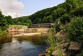
The Wiese is a river, 57.8 kilometres long, and a right-hand tributary of the Rhine in southwest Germany and northwest Switzerland.
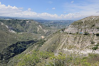
Siwalik is a highland region between the Mahabharat and Chure mountain ranges in Nepal.

A river is a natural flowing watercourse, usually freshwater, flowing towards an ocean, sea, lake or another river. In some cases a river flows into the ground and becomes dry at the end of its course without reaching another body of water. Small rivers can be referred to using names such as stream, creek, brook, rivulet, and rill. There are no official definitions for the generic term river as applied to geographic features, although in some countries or communities a stream is defined by its size. Many names for small rivers are specific to geographic location; examples are "run" in some parts of the United States, "burn" in Scotland and northeast England, and "beck" in northern England. Sometimes a river is defined as being larger than a creek, but not always: the language is vague.

Bridge scour is the removal of sediment such as sand and gravel from around bridge abutments or piers. Scour, caused by swiftly moving water, can scoop out scour holes, compromising the integrity of a structure.
An alluvial river is one in which the bed and banks are made up of mobile sediment and/or soil. Alluvial rivers are self-formed, meaning that their channels are shaped by the magnitude and frequency of the floods that they experience, and the ability of these floods to erode, deposit, and transport sediment. For this reason, alluvial rivers can assume a number of forms based on the properties of their banks; the flows they experience; the local riparian ecology; and the amount, size, and type of sediment that they carry.
The olive darter is a species of freshwater ray-finned fish, a darter from the subfamily Etheostomatinae, part of the family Percidae, which also contains the perches, ruffes and pikeperches. It is native to Tennessee, Kentucky, North Carolina, and Georgia, in the United States. It is found in the headwaters of Tennessee River system and the middle reaches of the Cumberland River system, its ideal habitat being clear, cold water over rocky substrates. It grows to a length of about 5 in (13 cm) and is an insectivore, feeding mainly on insect larvae on the riverbed. The fish matures at age two and lives till about age four. Up to 1500 eggs are spawned which fall to the riverbed and get lodged among gravel. The olive darter is classified as a "vulnerable species", being affected by habitat destruction and siltation, often resulting from damming and impoundment of the rivers or the creation of weirs. It is also affected by the change in the forest riparian habitat resulting from the killing of trees by the hemlock woolly adelgid.

A Steilhang is a geoscientific term for a steep mountainside or hillside, the average slope of which is greater than 1:2 or 30°. Leser defines a steilhang as a mountainside with an incline of between 16° and 60°, slopes of between 30° and 60° being described as "very steep" (übersteil) and anything over 60° being a rock face (wand).
River incision is the narrow erosion caused by a river or stream that is far from its base level. River incision is common after tectonic uplift of the landscape. Incision by multiple rivers result in a dissected landscape, for example a dissected plateau. River Incision is the natural process by which a river cuts downward into its bed, deepening the active channel. Though it is a natural process, it can be accelerated rapidly by human factors including land use changes such as timber harvest, mining, agriculture, and road and dam construction. The rate of incision is a function of basal shear-stress. Shear stress is increased by factors such as sediment in the water, which increase its density. Shear stress is proportional to water mass, gravity, and WSS:
Leaky dams are a flooding prevention measure, moderating the flow of water downstream. Barriers are added to a stream/river to prevent soil and silt escaping and allowing water to escape at a slower rate.

Korowya is a river of the Nile basin. Rising in the mountains of Dogu’a Tembien in northern Ethiopia, it flows westward to empty finally in the Weri’i and Tekezé River.

Glaciofluvial deposits or Glacio-fluvial sediments consist of boulders, gravel, sand, silt and clay from ice sheets or glaciers. They are transported, sorted and deposited by streams of water. The deposits are formed beside, below or downstream from the ice. They include kames, kame terraces and eskers formed in ice contact and outwash fans and outwash plains below the ice margin. Typically the outwash sediment is carried by fast and turbulent fluvio-glacial meltwater streams, but occasionally it is carried by catastrophic outburst floods. Larger elements such as boulders and gravel are deposited nearer to the ice margin, while finer elements are carried farther, sometimes into lakes or the ocean. The sediments are sorted by fluvial processes. They differ from glacial till, which is moved and deposited by the ice of the glacier, and is unsorted.

