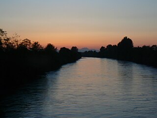
The Puyallup River is a river in the U.S. state of Washington. About 45 miles (72 km) long, it is formed by glaciers on the west side of Mount Rainier. It flows generally northwest, emptying into Commencement Bay, part of Puget Sound. The river and its tributaries drain an area of about 948 square miles (2,460 km2) in Pierce County and southern King County.

The Sauk River is a tributary of the Skagit River, approximately 45 miles (72 km) long, in northwestern Washington in the United States. It drains an area of the high Cascade Range in the watershed of Puget Sound north of Seattle. The river is a popular destination for fly fishing. It is a National Wild and Scenic River.

The Skykomish River is a 29-mile (47 km) long river in the U.S. state of Washington which drains the west side of the Cascade Mountains in the southeast section of Snohomish County and the northeast corner of King County. The river starts with the confluence of the North Fork Skykomish River and South Fork Skykomish River approximately one mile west of Index, then flowing northwesterly towards Puget Sound. It is joined by the Sultan River and the Wallace River at Sultan. It then meets the Snoqualmie River to form the Snohomish River at Monroe. The Snohomish River continues along the river valley eventually dumping into Port Gardner Bay on Possession Sound.

Mowich Lake is a lake located in the northwestern corner of Mount Rainier National Park in Washington state at an elevation of 4,929 feet (1,502 m). The name "Mowich" derives from the Chinook jargon word for deer.

The Vedder River, called the Chilliwack River above Vedder Crossing, is a river in the Canadian province of British Columbia and the U.S. state of Washington.
The Carbon River is a river in the U.S. state of Washington. It flows about 30 miles (48 km) from its source, the Carbon Glacier on Mount Rainier, to join the Puyallup River at Orting.

The Entiat River is a tributary of the Columbia River, joining the Columbia near Entiat. The United States Geological Survey (USGS) lists two variant names for the Entiat River: En-ti-at-kwa River and Entiatqua River. The river's name is derived from the Columbia-Moses (Salishan) term /nt'yátkw/ [nt'iátkw], meaning "place of grassy water"; another source states that it was called Enteatqua which means "Rapid Water" or "Rushing Water." The name, spelled "Entiat", was selected for the river in 1958 by the Chelan County Public Utility District.

The Naches River is a tributary of the Yakima River in central Washington in the United States. Beginning as the Little Naches River, it is about 75 miles (121 km) long. After the confluence of the Little Naches and Bumping River the name becomes simply the Naches River. The Naches and its tributaries drain a portion of the eastern side of the Cascade Range, east of Mount Rainier and northeast of Mount Adams. In terms of discharge, the Naches River is the largest tributary of the Yakima River.
Edmunds Glacier is located on Mount Rainier in the U.S. state of Washington. Named in 1883 for Vermont senator George F. Edmunds, the glacier lies on the western flank of the volcano below the steep, rocky Mowich Face and Sunset Face. Starting from an elevation of about 9,900 ft (3,000 m), the glacier flows northwest down to 7,000 ft (2,100 m) and ends northeast of the Jeanette Heights region of Mount Rainier. Meltwater from the Edmunds Glacier feeds the Mowich River which eventually merges with the Puyallup River.
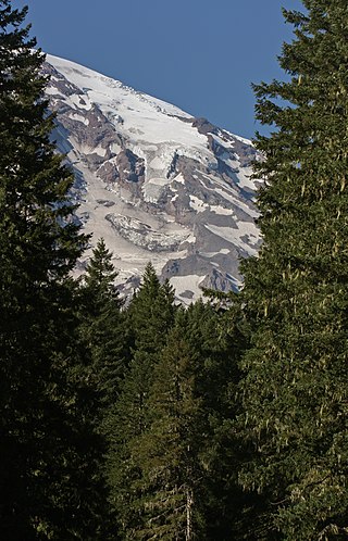
The Kautz Glacier is a narrow glacier on the southern flank of Mount Rainier in Washington. Named for August Kautz, who is sometimes credited for the first ascent of Mount Rainier, covers 1.8 square miles (4.7 km2) and contains 7.8 billion ft3 of ice. Upper Kautz Glacier extends south from the summit ice cap to Kautz Ice Cliff at about 11,700 feet (3,600 m). Immediately west of the main ice cliff, the glacier continues down Kautz Chute which terminates in another ice cliff just above the lower Kautz Glacier at 10,800 feet (3,300 m). Usually reached by a short descent from Camp Hazard at 11,300 feet (3,400 m) on Wapowety Cleaver, climbers following the Kautz Glacier climbing route ascend this chute to the upper glacier.
The South Mowich Glacier is a glacier located on the western flank of Mount Rainier in Washington. It covers 1.4 square miles (3.6 km2) and contains 4.5 billion ft3 of ice. Starting from the high-altitude cliffs above the Sunset Amphitheater at over 12,000 feet (3,700 m), the glacier flows west down Mount Rainier. The glacier is connected to the large Tahoma Glacier to the south near St. Andrews Rock at 11,000 feet (3,400 m). After leaving the Amphitheater, there is an icefall on the glacier where it plunges down below 10,000 feet (3,000 m). As the glacier descends, it gradually turns and by the time the South Mowich meets the Puyallup Glacier at 8,800 feet (2,700 m), the glacier is flowing northwest. As the glacier nears Jeanette Heights, it passes by several turns and becomes very rocky in comparison to the upper sections of the glacier. The glacier splits into two arms before their termini, with a shorter, northern arm ending at 5,500 feet (1,700 m) and the longer, larger southern arm ending near a stand of conifers at 5,100 ft (1,600 m). Meltwater from the glacier drains into the South Mowich River which eventually merges with the Puyallup River.

The Tahoma Glacier is a long glacier mostly on the western flank of Mount Rainier in Washington. It covers 1.2 square miles (3.1 km2) and contains 4.3 billion cubic feet of ice. The glacier starts out near the summit of the volcano at over 14,200 feet (4,300 m). As the glacier flows west-southwest out of the summit area, it cascades down a steep rocky face as an icefall from 13,200 feet (4,000 m) to 11,000 feet (3,400 m), where the glacier is connected to the South Mowich Glacier to the north in the Sunset Amphitheater. As the glacier drops below 10,000 feet (3,000 m), it broadens and joins the smaller South Tahoma Glacier. After the broad expanse of ice at over 8,000 feet (2,400 m), the Tahoma Glacier narrows as it descends around the rocky 7,690-foot (2,344 m) Glacier Island, a sub-peak of Rainier once fully encircled by both the South Tahoma and Tahoma Glaciers. Leaving the bottleneck in the glacier, the glacier splits; the larger, longer northern arm continues flowing west-southwest and terminates at around 5,500 feet (1,700 m). The southern arm flows south towards the arm of the South Tahoma Glacier, but this arm terminates before it rejoins the South Tahoma at 5,700 ft (1,700 m). Meltwater from the glacier is the source of the South Puyallup River and Tahoma Creek, a tributary of the Nisqually River.

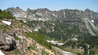
Tolmie Peak is a 5,920+ -foot peak in the Mount Rainier area of the Cascade Range, in the U.S. state of Washington. It is located 2 miles (3.2 km) northwest of Mowich Lake, in the northwest part of Mount Rainier National Park.

The Kitimat River is a river in the Canadian province of British Columbia. It originates in the Kitimat Ranges, near the sources of the Dala River, Kemano River, Atna River, and Clore River. It flows in a curve north, then west, then south, emptying into Kitimat Arm at the head of Douglas Channel, at the town of Kitimat.

For the Canadian community, see Paradise River, Newfoundland and Labrador

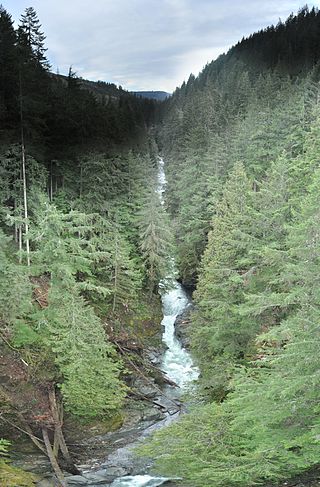
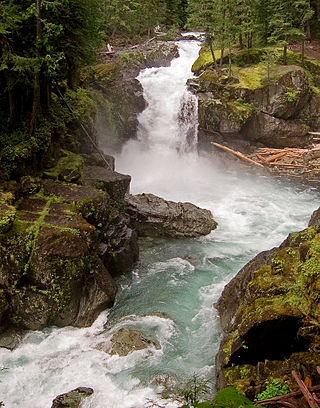
Kautz Creek is a tributary of the Nisqually River, flowing from the Kautz Glacier, with its watershed in the Mount Rainier National Park of Washington. It drains southwest from Mount Rainier for about 6 miles (9.7 km) before it joins the Nisqually River near Mount Rainier Highway. It is notable for being a severe flooding hazard due to the volume of summer glacier melt and its frequently changing course. The 400-foot (120 m) Kautz Creek Falls on the headwaters of the creek was formed by the retreat of the Kautz Glacier in the past 50 years.
Sulphide Creek is a 2.5-mile (4.0 km) glacial tributary of the Baker River in Whatcom County in the U.S. state of Washington, draining a steep and narrow canyon on the southeast flank of Mount Shuksan, inside North Cascades National Park. Although called a creek, it is river-like due to its high volume. The creek is fed by the "massive" Sulphide and Crystal glaciers above Sulphide Lake and it runs east collecting several small tributaries before flowing into the Baker River at elevation 869 feet (265 m). There are several very tall waterfalls occurring on the creek and its tributaries, the largest of which is Sulphide Creek Falls.

Icicle Creek is a non navigable stream in the U.S. state of Washington. It originates at Josephine Lake near the crest of the Cascade Range and flows generally east to join the Wenatchee River near Leavenworth. Icicle Creek's drainage basin is mountainous and mostly undeveloped land within the Wenatchee National Forest and the Alpine Lakes Wilderness. The final 6 miles (10 km) of the creek are moderately developed with scattered homes and pasture, a golf course, children's camp, a small housing development called Icicle Island Club, and the Leavenworth National Fish Hatchery. Some water is diverted from the creek for municipal use by the City of Leavenworth at Icicle Creek river mile 5.6. Near Leavenworth, the wheelchair-accessible Icicle Creek Nature Trail, a National Recreation Trail designated in 2005, runs 1.0 mile (1.6 km) along a historic creek channel.
The Ohanapecosh River is a 16-mile (26 km) river in the U.S. state of Washington.
Mother Mountain is a 6,480+ ft multi-summit, 3-mile long ridge-like mountain located in Mount Rainier National Park, in Pierce County of Washington state. It is part of the Cascade Range, and lies 7 mi (11 km) northwest of the summit of Mount Rainier. The Wonderland Trail provides one approach option to this mountain, and the summit offers views of Mount Rainier. East Fay Peak is its nearest higher neighbor, 0.42 mi (0.68 km) to the south. Precipitation runoff from Mother Mountain is drained by Cataract Creek on the south side of the mountain, and Ipsut Creek drains the north side of it, and both are tributaries of the Carbon River. The west side drains into Mowich Lake, and thence Mowich River.
