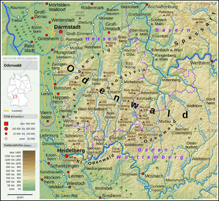
The Odenwald is a low mountain range in the German states of Hesse, Bavaria and Baden-Württemberg.

Mosbach is a town in the north of Baden-Württemberg, Germany. It is the seat of the Neckar-Odenwald district and has a population of approximately 25,000 distributed in six boroughs: Mosbach Town, Lohrbach, Neckarelz, Diedesheim, Sattelbach and Reichenbuch.
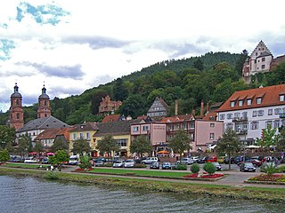
Miltenberg is a town in the Regierungsbezirk of Lower Franconia (Unterfranken) in Bavaria, Germany. It is the seat of the like-named district and has a population of over 9,000.
Bad Wimpfen is a historic spa town in the district of Heilbronn in the Baden-Württemberg region of southern Germany. It lies north of the city of Heilbronn, on the river Neckar.

Bad Rappenau is a city municipality in the district of Heilbronn in Baden-Württemberg in southern Germany. It is situated about 15 kilometres (9 mi) northwest of Heilbronn.

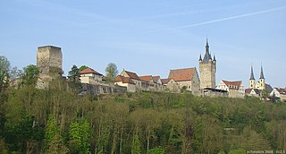
Buchen is a town in the German state of Baden-Württemberg. It is situated in the Odenwald low mountain range, 23 km northeast of the regional center Mosbach.

Bad Friedrichshall is a town in the district of Heilbronn in Baden-Württemberg in southern Germany. It is situated at the confluences of the Jagst and of the Kocher into the Neckar, some 10 kilometres (6 mi) north of Heilbronn. Bad Friedrichshall arose by the connection of Kochendorf and Jagstfeld in 1933, and is famous for its salt mine.

Hirschhorn (Neckar) is a small town in the Bergstraße district of Hesse, Germany, and is known as "The Pearl of the Neckar valley”. Hirschhorn is a climatic health resort situated in the Geo-Naturpark Bergstraße-Odenwald.

Wörth am Main is a town in the Miltenberg district in the Regierungsbezirk of Lower Franconia (Unterfranken) in Bavaria, Germany. It has a population of around 4,700.

Elztal is a municipality in the Neckar-Odenwald district, in Baden-Württemberg, Germany. It is named after the valley of the river Elz.

Limbach is a town in the district of Neckar-Odenwald-Kreis, in Baden-Württemberg, Germany.

Zwingenberg is a village in the Neckar-Odenwald district, in Baden-Württemberg, Germany.

Kirchzell is a market community in the Miltenberg district in the Regierungsbezirk of Lower Franconia (Unterfranken) in Bavaria, Germany.
Hesseneck is a village and a former municipality in the Odenwaldkreis (district) in Hesse, Germany. With only just over 600 inhabitants, Hesseneck was Hesse’s smallest self-governing community. Since January 2018, it is part of the new town Oberzent.

The Neckarelz–Osterburken railway is a 30.9 km long railway line in the north of the German state of Baden-Württemberg, which connects the Neckar and the Bauland along the edge of the Odenwald. It was opened in 1866 as part of the Odenwald Railway (Baden) (Odenwaldbahn) between Heidelberg and Würzburg. It has been upgraded to form an entirely double-track and electrified main line railway. It was an east–west axis for German long-distance transport until 1945. Since 2003 passenger services on it have been operated by the Rhine-Neckar S-Bahn. The Neckarelz–Mosbach section has also been served by the Heilbronn Stadtbahn since 2014.

The Upper Germanic-Rhaetian Limes, or ORL, is a 550-kilometre-long section of the former external frontier of the Roman Empire between the rivers Rhine and Danube. It runs from Rheinbrohl to Eining on the Danube. The Upper Germanic-Rhaetian Limes is an archaeological site and, since 2005, a UNESCO World Heritage Site. Together with the Lower Germanic Limes it forms part of the Limes Germanicus.

Zwingenberg Castle, also called Zwingenberg or Schloss Zwingenberg, stands on the right bank of the River Neckar where it cuts through the Odenwald hills in central Germany. The castle is located in the municipality of Zwingenberg in the state of Baden-Württemberg.

The Neckar-Odenwald Limes is a collective term for two, very different early sections of the Upper Germanic-Rhaetian Limes, a Roman defensive frontier line that may have been utilised during slightly different periods in history. The Neckar-Odenwald Limes consists of the northern Odenwald Limes (Odenwaldlimes), a cross-country limes with camps, watchtowers and palisades, which linked the River Main with the Neckar, and the adjoining southern Neckar Limes (Neckarlimes), which in earlier research was seen as a typical 'riverine limes', whereby the river replaced the function of the palisade as an approach obstacle. More recent research has thrown a different light on this way of viewing things that means may have to be relativized in future. The resulting research is ongoing.
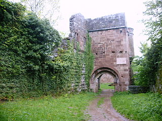
Wildenberg Castle, also called the Wildenburg, is a ruined, Hohenstaufen period castle in the Odenwald hills in Germany. It is located in the parish of Preunschen in the municipality of Kirchzell, in the Lower Franconian district of Miltenberg in Bavaria.

The Bergstraße-Odenwald Nature Park is a nature park in southern Germany with an area of 3,500 km² that lies between the rivers Rhine, Main (river) and Neckar. In the south it overlaps in places with the Neckar Valley-Odenwald Nature Park on the territory of Baden-Württemberg. In the east it meets the Bavarian Spessart Nature Park at the River Main. The nature park covers parts of the states of Baden-Württemberg, Bavaria and Hesse.


