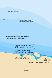
The Territory of Ashmore and Cartier Islands is an uninhabited external territory of Australia consisting of four low-lying tropical islands in two separate reefs, and the 12 nautical mile territorial sea generated by the islands. The territory is located in the Indian Ocean situated on the edge of the continental shelf, about 320 km (199 mi) off the northwest coast of Australia and 144 km (89 mi) south of the Indonesian island of Rote.

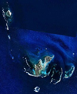
The Coral Sea Islands Territory is an external territory of Australia which comprises a group of small and mostly uninhabited tropical islands and reefs in the Coral Sea, northeast of Queensland, Australia. The only inhabited island is Willis Island. The territory covers 780,000 km2 (301,160 sq mi), most of which is ocean, extending east and south from the outer edge of the Great Barrier Reef and includes Heralds Beacon Island, Osprey Reef, the Willis Group and fifteen other reef/island groups. Cato Island is the highest point in the Territory.

An atoll, sometimes called a coral atoll, is a ring-shaped coral reef including a coral rim that encircles a lagoon partially or completely. There may be coral islands or cays on the rim. The coral of the atoll often sits atop the rim of an extinct seamount or volcano which has eroded or subsided partially beneath the water. The lagoon forms over the volcanic crater or caldera while the higher rim remains above water or at shallow depths that permit the coral to grow and form the reefs. For the atoll to persist, continued erosion or subsidence must be at a rate slow enough to permit reef growth upward and outward to replace the lost height.

The Tasman Sea is a marginal sea of the South Pacific Ocean, situated between Australia and New Zealand. It measures about 2,000 kilometres (1,200 mi) across and about 2,800 kilometres (1,700 mi) from north to south. The sea was named after the Dutch explorer Abel Janszoon Tasman, who was the first recorded European to encounter New Zealand and Tasmania. The British explorer Captain James Cook later extensively navigated the Tasman Sea in the 1770s as part of his first voyage of exploration.
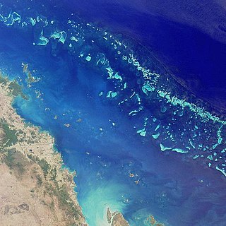
The Great Barrier Reef is the world's largest coral reef system composed of over 2,900 individual reefs and 900 islands stretching for over 2,300 kilometres (1,400 mi) over an area of approximately 344,400 square kilometres (133,000 sq mi). The reef is located in the Coral Sea, off the coast of Queensland, Australia. The Great Barrier Reef can be seen from outer space and is the world's biggest single structure made by living organisms. This reef structure is composed of and built by billions of tiny organisms, known as coral polyps. It supports a wide diversity of life and was selected as a World Heritage Site in 1981. CNN labelled it one of the seven natural wonders of the world. The Queensland National Trust named it a state icon of Queensland.

Capricornia Cays is both a national park and a scientific national park in Queensland (Australia), located 486 km and 472 km north of the state capital Brisbane respectively. Collectively they comprise 241 ha of coral cays.

The Coral Sea is a marginal sea of the South Pacific off the northeast coast of Australia, and classified as an interim Australian bioregion. The Coral Sea extends 2,000 kilometres (1,200 mi) down the Australian northeast coast.

The Torres Strait is a strait which lies between Australia and the Melanesian island of New Guinea. It is approximately 150 km (93 mi) wide at its narrowest extent. To the south is Cape York Peninsula, the northernmost extremity of the Australian mainland. To the north is the Western Province of Papua New Guinea. It is named after navigator Luís Vaz de Torres, who passed through the Strait in 1606.

A cay, also spelled caye or key, is a small, low-elevation, sandy island on the surface of a coral reef. Cays occur in tropical environments throughout the Pacific, Atlantic and Indian Oceans.
The Gay and Lesbian Kingdom of the Coral Sea Islands was a micronation established as a symbolic political protest by a group of gay rights activists based in Australia. Declared in 2004 in response to the Australian government's refusal to recognise same-sex marriages, it was founded on Australia's external overseas Territory of the Coral Sea Islands, a group of uninhabited islets east of the Great Barrier Reef. The Kingdom was dissolved on 17 November 2017 following the decision made by the Australian people to legalize gay marriage.

Elizabeth and Middleton Reefs Marine National Park Reserve is a former Marine protected area consisting of waters around Elizabeth and Middleton Reefs located at the south-eastern end of the Coral Sea Islands, an Australian territory in the Coral Sea and the north-western Tasman Sea. It was incorporated into the new Lord Howe Commonwealth Marine Reserve in December 2012. The two reefs also form a Ramsar site, having been listed as Ramsar Site 1223, on 21 October 2002, under the Ramsar Convention as a wetland of international importance.
Eagle Island is in a national park in Queensland, Australia, 692 km north-west of Brisbane. The island is part of the Lizard Island Group and is south of Lizard Island situated 270 km north of Cairns, Queensland.

North West Cape is a peninsula in the north-west of Western Australia. Cape Range runs down the spine of the peninsula and Ningaloo Reef runs along the western edge. It includes the town of Exmouth.
The Muirfield Seamount is a submarine mountain located in the Indian Ocean approximately 130 kilometres southwest of the Cocos (Keeling) Islands. The Cocos Islands are an Australian territory, and therefore the Muirfield Seamount is within Australia's Exclusive Economic Zone (EEZ). The Muirfield Seamount is a submerged archipelago, approximately 2.5 kilometres in diameter and 16–18 metres below the surface of the sea. A 1999 biological survey of the seamount performed by the Australian Commonwealth Scientific and Industrial Research Organisation (CSIRO) revealed that the area is depauperate.
The Wallabi Group is the northern-most group of islands in the Houtman Abrolhos. Nominally located at 28°28′S113°42′E, it is 58 kilometres from the Australian mainland, and about 9 kilometres from the Easter Group.

The Pelsaert Group is the southernmost of the three groups of islands that make up the Houtman Abrolhos island chain. Nominally located at 28°54′S113°54′E, it consists of a number of islands, the largest of which are Gun Island, Middle Island, and Pelsaert Island. The group is named after a Dutch "opperkoopman" who stranded nearby with the VOC-ship "Batavia" in 1629. The group contains the most southerly true coral reefs in the Indian Ocean. The group is part of the Houtman Abrolhos Important Bird Area, identified as such by BirdLife International because of its importance for supporting large numbers of breeding seabirds.

The 1987 Open Championship was a men's major golf championship and the 116th Open Championship, held from 16–19 July at Muirfield Golf Links in Gullane, Scotland. Nick Faldo won the first of his three Open Championships, one stroke ahead of runners-up Paul Azinger and Rodger Davis. It was the first of Faldo's six major championships. It was the first win at The Open by an Englishman since Tony Jacklin in 1969.

Cato Reef, a part of the Cato Bank, is an area in the Coral Sea off the central coast of Queensland, Australia that is of approximately 21 by 13 km of this 200 km2 (77 sq mi) area, where depth of water is typically less than 17 m (56 ft). Upon Cato Bank Cato Reef encircles an area of 3.3 by 1.8 km, area 5 km2 (1.9 sq mi) including a small shallow lagoon which contains Cato Island, a low-relief cay in the west that is approximately 650 by 300 m, area 15 hectares, 6 m (20 ft) high. Close to the southeast corner of Cato Bank is Hutchison Rock, with one metre (3.3 ft) depth over it.
The islands and reefs of the Capricorn and Bunker Group are situated astride the Tropic of Capricorn at the southern end of the Great Barrier Reef, approximately 80 kilometres east of Gladstone, which is situated on the central coast of the Gladstone Region, Queensland, Australia.

Sir Joseph Banks Group Conservation Park is a protected area in the Australian state of South Australia located on the Sir Joseph Banks Group in Spencer Gulf about 25 kilometres (16 mi) east-northeast of Port Lincoln. The conservation park of which specific islands had been previously declared as Flora and Fauna Reserves under statutes in force prior to 1972, was proclaimed in 1972 under the National Parks and Wildlife Act 1972. It was declared ‘primarily for the conservation of Cape Barren geese, and to protect marine mammal habitat’. As of 1996, the conservation park did not include Spilsby island which is privately owned and ‘lighthouse reserves’ on other islands while the following islands have been added post-declaration - Reevesby Island which was added in 1974 and Dangerous Reef which was added in 1989. The conservation park was subsequently extended to include the waters within 2 nautical miles (4 km) of the shoreline of all islands in the group and Dangerous Reef via a declaration under the National Parks and Wildlife Act 1972 for the purpose of regulating and managing great white shark berleying activities. The conservation park is classified as an IUCN Category Ia protected area.