
Hancock County is a county located in the northeastern part of the U.S. state of Tennessee. As of the 2010 census, the population was 6,819, making it the fourth-least populous county in Tennessee. Its county seat is Sneedville.
Powell Mountain is a mountain ridge of the Ridge-and-valley Appalachians of the Appalachian Mountains. It is a long and narrow ridge, running northeast to southwest, from about Norton, Virginia to near Tazewell, Tennessee. It separates the Clinch River basin and the Powell River basin of Powell Valley. It was named for an 18th-century explorer.
Niota is an unincorporated community in Appanoose Township, Hancock County, in the U.S. state of Illinois. The community is located on the bank of the Mississippi River and is at the eastern end of the Fort Madison Toll Bridge, which connects Niota to Fort Madison, Iowa. Niota is the western terminus of Illinois Route 9 and is also served by Illinois Route 96, which is part of the Great River Road.
Newcomb is an unincorporated community in Campbell County, Tennessee, United States. It is situated in the Elk Fork Creek Valley in the Cumberland Mountains, southwest of Jellico. Tennessee State Route 297 passes through the community.
Dancyville is an unincorporated community in Haywood County, Tennessee, United States. Dancyville is located at latitude 35.408 and longitude -89.294, at the intersection of Tennessee State Route 76 and Tennessee State Route 179, near Interstate 40. The elevation is 404 feet. Dancyville appears on the Dancyville U.S. Geological Survey Map. Haywood County is in the Central Time Zone, and it observes daylight saving time.

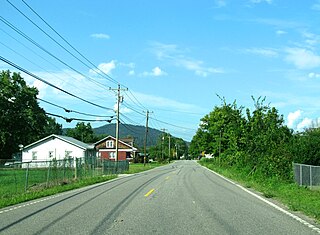
Xenophon is an unincorporated community in Hancock County, Tennessee, United States. Xenophon is located on Tennessee State Route 33 6.6 miles (10.6 km) west-southwest of Sneedville.

Mulberry is an unincorporated community in Lincoln County, Tennessee, United States. Mulberry is located along Tennessee State Route 50, 7.4 miles (11.9 km) northeast of Fayetteville. Mulberry has a post office with ZIP code 37359, which opened on January 7, 1828. The community was named for the red mulberry plants found in the area.

Elk Valley is an unincorporated community in Campbell County, Tennessee, United States. It is situated at the northern end of a broad valley of the same name in the Cumberland Mountains, southwest of Jellico. Tennessee State Route 297 passes through the community.
White Oak Mountain is a mountain located in northwestern Georgia and southeastern Tennessee. The mountain is part of the Ridge and Valley Appalachians.

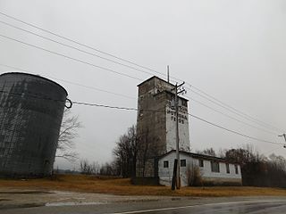
Old Niota is an unincorporated community in Hancock County, Illinois, United States.
Elderville is an unincorporated community in Hancock County, Illinois, United States.
Laurel Fork is an unincorporated community in Carter County, Tennessee, United States.

Mulberry is an unincorporated community in Chilton County, Alabama, United States.
Mulberry is an unincorporated community in Crenshaw County, Alabama, United States.
Glimp is an unincorporated community in Lauderdale County, Tennessee, United States. The community is located along Tennessee State Route 87 northwest of Henning.
Cherry is an unincorporated community in Lauderdale County, Tennessee, United States. It is located at the intersection of Tennessee State Route 87 and Tennessee State Route 371. Cherry is composed of some churches, a few small businesses, homes, and farms.
Windrow is an unincorporated community in Rutherford County, Tennessee, United States.
Boomer is an unincorporated community in Cocke County, Tennessee, United States.
The East Tennessee Crossing Byway is a 83-mile (134 km) National Scenic Byway in the U.S. state of Tennessee. Established in 2009, it is one of the newest byways in the National Scenic Byway system. The scenic byway traverses mostly along an unsigned concurrency of U.S. Route 25E/State Route 32 (US 25E/SR 32) in East Tennessee.
Primrose is an unincorporated community in Tarrant County, located in the U.S. state of Texas. The community is located ten miles south-west of Fort Worth, and east of Benbrook Lake.


