Gyeongsang was one of the eight provinces of Korea during the Joseon dynasty. Gyeongsang was located in the southeast of Korea.
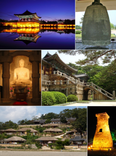
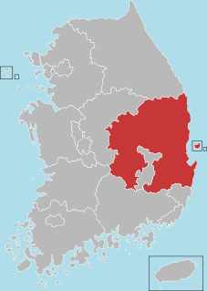
Yeongnam is a region that coincides with the former Gyeongsang Province in what is now South Korea.

Miryang, often spelled Milyang, is a city in Gyeongsangnam-do Province, South Korea. Neighboring cities include Changnyeong to the west, Cheongdo to the north, Ulsan to the east, and Yangsan, Gimhae, and Changwon to the south. The city bird is the Korean magpie, the city tree is the pine, and the city flower is the royal azalea.

The Sobaek Mountains are a mountain range cutting across the southern Korean peninsula. They split off from the Taebaek Mountains and trend southwest across the center of the peninsula. They are traditionally considered to reach their southwestern limit at Jirisan, which is also the highest peak of the range. Other famous mountains in the range include Songni Mountain, Joryeong Mountain, Gaya Mountain, Worak Mountain, and Sobaek Mountain itself. The peaks of the Sobaek Mountains are generally well over 1000 m above sea level.

Eonyang is an eup, or large village, in Ulju-gun, a largely rural district of Ulsan, South Korea. It is near the Seoknam Nun's Temple. It has a traditional market every five days.
The Alps is a major European mountain range.
The Dongdae Mountains are a small outlying range of the Taebaek Mountains. They run along the east coast of South Korea through the cities of Pohang, Gyeongju, and Ulsan. Notable peaks include Toham Mountain in Gyeongju National Park, as well as Dongdae Mountain itself in Ulsan. The Dongdae Mountains separate the Hyeongsan River basin from the belt of small streams flowing directly into the Sea of Japan.
The Yeongnam Alps are a outlying range of the Taebaek Mountains. They consist of a group of relatively tall mountains in the Yeongnam region of southeastern South Korea. They are much shorter than the European Alps, only slightly over 1000 m. The term is sometimes restricted to those peaks exceeding 1000 m in height, but may be informally extended to lower peaks in the same region.
Cheontaesan is a 631-meter-high mountain in Gyeongsangnam-do, South Korea, on the border between Miryang and Yangsan cities. It lies near the southern end of the Yeongnam Alps, and looks south across the Nakdong River to Gimhae. Cheontaesan is connected to Geumosan to its north.
Pyochungsa, originally Jungnimsa, is a Korean Buddhist temple of the Jogye Order of Korean Buddhism. It stands on the slopes of Jaeyaksan mountain near Cheonhwangsan in the Yeongnam Alps in Danjang-myeon, northern Miryang, South Korea.

Cheonhwangsan is a mountain in South Korea. It sits on the boundary between the city of Ulsan and the city of Miryang, in the province of Gyeongsangnam-do. Cheonhwangsan has an elevation of 1,189 m (3,901 ft). It is part of the Yeongnam Alps mountain range.
Gajisan is a mountain in South Korea. It sits on the boundary between the city of Ulsan, the city of Miryang in the province of Gyeongsangnam-do, and Cheongdo County in Gyeongsangbuk-do. Gajisan has an elevation of 1,240 m (4,068 ft). It is part of the Yeongnam Alps mountain range.
Ganwolsan is a mountain in the city of Ulsan, South Korea. It has an elevation of 1,083.1 m (3,553 ft). It is part of the Yeongnam Alps mountain range.
Goheonsan is a mountain in the vicinity of the city of Ulsan, South Korea. It has an elevation of 1,032 m (3,386 ft). It is part of the Yeongnam Alps mountain range.
Sinbulsan is a mountain in South Korea. It extends over the cities of Ulsan and Yangsan in Gyeongsangnam-do. Sinbulsan has an elevation of 1,209 m (3,967 ft). It is part of the Yeongnam Alps mountain range.
Yeongchuksan is a mountain in South Korea. It extends over the cities of Ulsan and Yangsan in Gyeongsangnam-do. This mountain is also referred to as Yeongchwisan (영취산), Chwiseosan (취서산), and Chukseosan (축서산). Yeongchuksan has an elevation of 1,081 m (3,547 ft). It is part of the Yeongnam Alps mountain range.

The Rams Head is a mountain located in the Ramshead Range of the Snowy Mountains in New South Wales, Australia.
Jaeyaksan is a mountain of South Korea. It has an elevation of 1,108 metres. It is part of the Yeongnam Alps mountain range.
Unmunsan is a mountain of Gyeongsangbuk-do, eastern South Korea. It has an elevation of 1,195 metres. It is part of the Yeongnam Alps mountain range.