Municipal Buildings, Dumbarton

Last updated

Dumbarton Municipal Buildings
Dumbarton Municipal Buildings - geograph.org.uk - 3251296.jpg
Dumbarton Municipal Buildings
LocationGlasgow Road, Dumbarton
Coordinates 55°56′45″N4°34′03″W / 55.9459°N 4.5675°W / 55.9459; -4.5675
Built1903
ArchitectJames Thomson
Architectural style(s) Scottish baronial style
Listed Building – Category B
Official nameGlasgow Road Municipal Buildings and Gatepiers
Designated31 January 1984
Reference no.LB24881
West Dunbartonshire UK location map.svg
Red pog.svg
Shown in West Dunbartonshire

Dumbarton Municipal Buildings is a structure in Glasgow Road, Dumbarton, West Dunbartonshire, Scotland. The structure, which is used as a venue for weddings and civil partnership ceremonies, is a Category B listed building. [1]

Contents

History

The three cannon MacFarlan's Hurdles. Three Burmese cannon. Municipal Buildings. Dumbarton.jpg
The three cannon
The Second Boer War Memorial (left, background) and the pointed arch from the Collegiate Church of St Mary (right, foreground) The College Bow - geograph.org.uk - 919940.jpg
The Second Boer War Memorial (left, background) and the pointed arch from the Collegiate Church of St Mary (right, foreground)

For much of the latter half of the 19th century the burgh council was based in Dumbarton Burgh Hall. However, they shared the building with Dumbarton Academy and, in the late 19th century, burgh leaders decided to commission a bespoke building. The site they selected on the north side of Glasgow Road was occupied by College Park House, the headquarters of the shipbuilders, Archibald McMillan & Son; the house was demolished and the land was presented to the burgh council by the chemical manufacturer, John White, 1st Baron Overtoun. [2] Construction of the new building started in 1899. It was designed by James Thomson of Baird & Thomson in Glasgow in the Scottish baronial style, built in red sandstone and was completed in 1903. [3]

The design involved an asymmetrical main frontage with eleven bays facing onto Glasgow Road; the central bay, which slightly projected forward, contained a three-stage tower. The tower featured a round headed doorway with a moulded architrave in the first stage, an ogival-shaped window in the second stage and a pair of mullioned windows surmounted by the burgh coat of arms and flanked by corner bartizans in the third stage. There was a pyramid-shaped roof to the tower. The first three bays on the left formed a section which was also slightly projected forward and contained an oriel window in the central bay and a stepped gable with finials above. The connecting section of two bays to the left of the tower and the whole of the section to the right of the tower were fenestrated by casement windows on both floors. The second and third bays from the right were surmounted by a stepped gable. Internally, the principal room was the council chamber which featured leaded windows depicting science, engineering, truth, justice, fortitude, and faith. A stained glass window was installed on the staircase to commemorate the Coronation of Edward VII and Alexandra. [1]

A statue of the shipbuilder and shipowner, Peter Denny, sculpted by Sir Hamo Thornycroft, was erected in front of the building in 1902. [4] Various other monuments were placed to the east of the building: three cannon, which had been captured during the Third Anglo-Burmese War, were placed there at the time of its opening. [5] A pointed arch from the Collegiate Church of St Mary, which had been founded by Isabella, Countess of Lennox in 1454 and demolished to make was for Dumbarton Central railway station in the mid-19th century, was placed just to the south of the three cannon. [6] A war memorial, in the form of a Celtic cross designed by the sculptor John Gilfillan, which was intended to commemorate the lives of local service personnel who had died in the Second Boer War, was erected just to the south of the arch and unveiled by the Lord Lieutenant of Dunbartonshire, Sir James Colquhoun, 5th Baronet, on 9 October 1904. [7] [8]

The building continued to serve as the headquarters of Dumbarton Town Council until the burgh's abolition in 1975. [9] The larger replacement Dumbarton District Council established its main offices at Crosslet House on Argyll Avenue, but continued to use the Municipal Buildings as additional office space and held its meetings in the council chamber there. [10] [11] [12]

The building passed to West Dunbartonshire Council when local government was reorganised again in 1996. An extensive programme of refurbishment works, which included roof repairs and restoration of the council chamber, was completed at a cost of £1.4 million in 2018. [13] [14] The works enabled the council to provide modern office accommodation for their staff including those in the registrar's department and also to provide appropriate surroundings for weddings and civil partnership ceremonies. [15]

See also

Related Research Articles

<span class="mw-page-title-main">West Dunbartonshire</span> Council area of Scotland

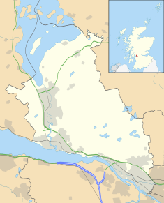
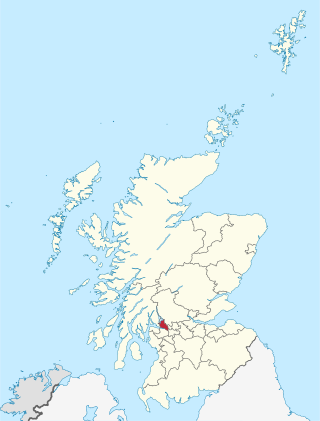
West Dunbartonshire is one of the 32 local government council areas of Scotland. The area lies to the north-west of the Glasgow City council area and contains many of Glasgow's commuter towns and villages. West Dunbartonshire also borders Argyll and Bute, East Dunbartonshire, Renfrewshire and Stirling.

<span class="mw-page-title-main">Dunbartonshire</span> Historic county in Scotland

Dunbartonshire or the County of Dumbarton is a historic county, lieutenancy area and registration county in the west central Lowlands of Scotland lying to the north of the River Clyde. Dunbartonshire borders Perthshire to the north, Stirlingshire to the east, Lanarkshire and Renfrewshire to the south, and Argyllshire to the west.

<span class="mw-page-title-main">Dumbarton</span> Town in Scotland

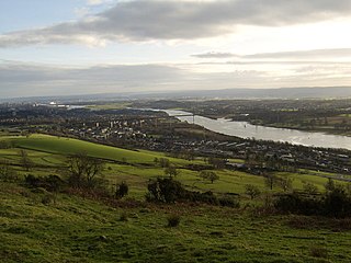
Dumbarton is a town in West Dunbartonshire, Scotland, on the north bank of the River Clyde where the River Leven flows into the Clyde estuary. In 2006, it had an estimated population of 19,990.

<span class="mw-page-title-main">Port Glasgow</span> Town in the Inverclyde council area of Scotland

Port Glasgow is the second-largest town in the Inverclyde council area of Scotland. The population according to the 1991 census for Port Glasgow was 19,426 persons and in the 2001 census was 16,617 persons. The most recent census in 2011 states that the population has declined to 15,414. It is located immediately to the east of Greenock and was previously a burgh in the county of Renfrewshire.

<span class="mw-page-title-main">Clydebank</span> Town in Scotland

Clydebank is a town in West Dunbartonshire, Scotland. Situated on the north bank of the River Clyde, it borders the village of Old Kilpatrick to the west, and the Yoker and Drumchapel areas of the adjacent City of Glasgow immediately to the east. Depending on the definition of the town's boundaries, the suburban areas of Duntocher, Faifley and Hardgate either surround Clydebank to the north, or are its northern outskirts, with the Kilpatrick Hills beyond.

<span class="mw-page-title-main">Dumbarton Castle</span> Historic location in Dumbarton, Scotland

Dumbarton Castle has the longest recorded history of any stronghold in Scotland. It sits on a volcanic plug of basalt known as Dumbarton Rock which is 240 feet (73 m) high and overlooks the Scottish town of Dumbarton.

<span class="mw-page-title-main">Dumbarton (district)</span> Former local government district in Scotland

Dumbarton was, from 1975 to 1996, one of nineteen local government districts in the Strathclyde region of Scotland, covering the town of Dumbarton and surrounding areas to the north-west of Glasgow.

<span class="mw-page-title-main">Dumbarton Academy</span> Secondary school in Dumbarton, West Dunbartonshire, Scotland

Founded in 1485, Dumbarton Academy is a mixed secondary school in Dumbarton, West Dunbartonshire, Scotland.

<span class="mw-page-title-main">Dumbarton Burgh Hall</span> Municipal Building in Dumbarton, Scotland

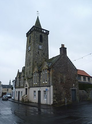
Dumbarton Burgh Hall is a municipal structure in Church Street, Dumbarton, West Dunbartonshire, Scotland. The building, which is the headquarters of West Dunbartonshire Council, is Category A listed.

<span class="mw-page-title-main">Pollokshaws Burgh Hall</span> Municipal building in Pollokshaws, Scotland

The Pollokshaws Burgh Hall is a municipal building at the edge of Pollok Country Park, Glasgow, Scotland. The burgh hall, which was briefly the headquarters of Pollokshaws Burgh Council, is a Category A listed building.

<span class="mw-page-title-main">Clydebank Town Hall</span> Municipal Building in Clydebank, Scotland

Clydebank Town Hall is a municipal building in Dumbarton Road, Clydebank, Scotland. The town hall, which was the headquarters of Clydebank Burgh Council, is a Category B listed building.

<span class="mw-page-title-main">Prestwick Burgh Hall</span> Municipal building in Prestwick, Scotland

Prestwick Burgh Hall, also known as Prestwick Freeman's Hall and Prestwick Freemen's Hall, is a municipal building in Kirk Street, Prestwick, Scotland. The structure, which served as the meeting place of Prestwick Burgh Council, is a Category B listed building.

<span class="mw-page-title-main">Town Buildings, Port Glasgow</span> Municipal building in Port Glasgow, Scotland

The Town Buildings, also known as the Municipal Buildings, are in Fore Street, Port Glasgow, Scotland. The structure, which served as the meeting place of Port Glasgow Burgh Council, is a Category A listed building.

<span class="mw-page-title-main">Municipal Buildings, Helensburgh</span> Municipal building in Helensburgh, Scotland

The Municipal Buildings are based on the north side of Princes Street East in Helensburgh, Scotland. The structure, which served as the meeting place of Helensburgh Burgh Council, is a Category B listed building.

<span class="mw-page-title-main">Galashiels Burgh Chambers</span> Municipal building in Galashiels, Scotland

Galashiels Burgh Chambers is a municipal building in Albert Place, Galashiels, Scotland. The building, which was the headquarters of Galashiels Burgh Council, is a Category B listed building.

<span class="mw-page-title-main">Burntisland Burgh Chambers</span> Municipal building in Burntisland, Scotland

Burntisland Burgh Chambers is a municipal structure in the High Street, Burntisland, Fife, Scotland. The building, which is the meeting place of the Burntisland Community Council, is a Category B listed building.

<span class="mw-page-title-main">Auchtermuchty Town House</span> Municipal building in Auchtermuchty, Scotland

Auchtermuchty Town House is a municipal structure in the High Street, Auchtermuchty, Fife, Scotland. The structure, which accommodates the local public library, is a Category B listed building.

<span class="mw-page-title-main">Crieff Town Hall</span> Municipal building in Kirkwall, Scotland

Crieff Town Hall is a municipal building in the High Street, Crieff, Perth and Kinross, Scotland. The structure, which is currently used as a tourist information centre and museum, is a Category B listed building.

<span class="mw-page-title-main">County Buildings, Dumbarton</span> Former county hall in Dumbarton, Scotland

County Buildings was a municipal structure in Garshake Road, Dumbarton, West Dunbartonshire, Scotland. The complex was the headquarters of Dunbartonshire County Council and was subsequently used as council offices for West Dunbartonshire Council.

<span class="mw-page-title-main">Dumbarton Sheriff Court</span> Courthouse in Dumbarton, Scotland

Dumbarton Sheriff Court is a judicial structure in Church Street, Dumbarton, West Dunbartonshire, Scotland. The complex, which was the headquarters of Dunbartonshire County Council and is currently used as a courthouse, is a Category B listed building.

References

  1. 1 2 Historic Environment Scotland. "Glasgow Road Municipal Buildings and Gatepiers (LB24881)" . Retrieved 1 August 2022.
  2. "The Municipal Buildings". Open Days 2022. Retrieved 1 August 2022.
  3. "Dumbarton Municipal Buildings". Dictionary of Scottish Architects. Retrieved 1 August 2022.
  4. Historic Environment Scotland. "Peter Denny Statue, Municipal Buildings, Church Street, Dumbarton (LB24882)" . Retrieved 1 August 2022.
  5. Memorials And Trophies – Cannon in Britain from the Third Anglo-Burmese War. Journal of the Society for Army Historical Research. 2016. pp. 107–128.
  6. Historic Environment Scotland. "Church Street, College Bow (former tower arch of St Mary's Collegiate Church) (LB24876)" . Retrieved 1 August 2022.
  7. "Boer War Memorial Dumbarton". Traces of War. Retrieved 1 August 2022.
  8. "Dumbarton Bower War Memorial". Roll of Honour. Retrieved 3 June 2021.
  9. "Local Government (Scotland) Act 1973". Legislation.gov.uk. Retrieved 16 April 2020.
  10. "No. 19800". The Edinburgh Gazette . 6 January 1976. p. 4.
  11. "District Council news". Lennox Herald. Dumbarton. 18 December 1992. p. 22. Retrieved 19 February 2023.
  12. "Historic Crosslet House knocked down for £10million 'super' care home". Dumbarton and Vale of Leven Reporter. 16 September 2015. Retrieved 1 August 2022.
  13. "Upgrade of Dumbarton's Municipal Buildings begins". BBC. 23 March 2016. Retrieved 1 August 2022.
  14. "Work On £1.4m Building Refurb In Dumbarton Complete". Build Scotland. 9 January 2018. Retrieved 3 June 2021.
  15. "Dumbarton Heritage Trail". West Dunbartonshire Council. 21 October 2013. p. 5. Retrieved 3 June 2021.