Sylt is an island in northern Germany, part of Nordfriesland district, Schleswig-Holstein, and well known for the distinctive shape of its shoreline. It belongs to the North Frisian Islands and is the largest island in North Frisia. The northernmost island of Germany, it is known for its tourist resorts, notably Westerland, Kampen and Wenningstedt-Braderup, as well as for its 40-kilometre-long (25-mile) sandy beach. It is frequently covered by the media in connection with its exposed situation in the North Sea and its ongoing loss of land during storm tides. Since 1927, Sylt has been connected to the mainland by the Hindenburgdamm causeway. In later years, it has been a resort for the German jet set and tourists in search of occasional celebrity sightings.
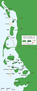
The North Frisian Islands are the Frisian Islands off the coast of North Frisia.

Föhrpronunciation (help·info) is one of the North Frisian Islands on the German coast of the North Sea. It is part of the Nordfriesland district in the federal state of Schleswig-Holstein. Föhr is the second-largest North Sea island of Germany and a popular destination for tourists. A town and eleven distinct municipalities are located on the island. The climate is oceanic with moderate winters and relatively cool summers.

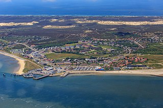
Westerland is a seaside resort and a former municipality located on the German North Sea island of Sylt. Since 1 January 2009, Westerland has been part of the municipality Gemeinde Sylt. Westerland is part of the Nordfriesland district in Schleswig-Holstein. It is the largest resort on the island, the local transportation hub and the centre of Sylt's tourist industry.
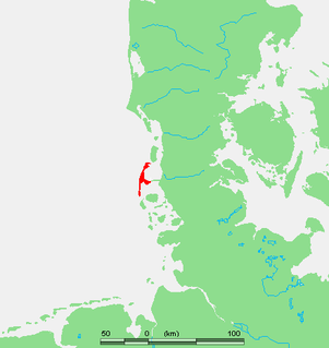
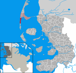
Landschaft Sylt is an Amt in the district of Nordfriesland, in Schleswig-Holstein, Germany. It covers the island of Sylt, in the North Sea, about 65 km northwest of Husum. Its administrative seat is in the town Westerland - which is not, however, a part of the Amt.

The Hindenburgdamm or Hindenburg Dam is an 11 km-long causeway joining the North Frisian island of Sylt to mainland Schleswig-Holstein. Its coordinates are 54°53′N8°33′E. It was opened on 1 June 1927 and is exclusively a railway corridor. The companies that built the Hindenburgdamm, a job that took four years, were Philipp Holzmann AG of Frankfurt, working from the mainland, and Peter Fix Söhne of Duisburg working from Sylt. A train trip along the causeway takes about 10 minutes, and the time between the auto terminals at Niebüll on the mainland and Westerland on Sylt is about 30 minutes. The Hindenburgdamm is part of the railway line known as the Marschbahn, which is double-tracked along much of the route, although there as yet exists a single-tracked stretch. On the causeway is a signal box.
List auf Sylt is the northernmost municipality in Germany, located on the North Sea island of Sylt close to Denmark in the district of Nordfriesland in the state of Schleswig-Holstein.

Hörnum (help·info) is a municipality in the district of Nordfriesland, in Schleswig-Holstein, Germany. It is located on the southern headland of the island of Sylt. The municipality is part of the Amt Landschaft Sylt. The economy is dominated by tourism.

Kampen (help·info) is a municipality and seaside resort on the island Sylt, in the district of Nordfriesland, in Schleswig-Holstein, Germany. It is located north of the island's main town, Westerland. The municipality is part of the AmtLandschaft Sylt. The local economy is dominated by tourism.
Rantum is a village and a former municipality on the island of Sylt in the district of Nordfriesland, in Schleswig-Holstein, Germany. Since 1 January 2009, it has been an Ortsteil (part) of the municipality Sylt.

Wenningstedt-Braderup is a municipality and seaside resort on the island of Sylt in the district of Nordfriesland, in Schleswig-Holstein, Germany. It is located north of the town of Westerland and is part of the Amt Landschaft Sylt. The local economy is dominated by tourism.

Sylt-Ost is a former municipality on the island of Sylt, in the district of Nordfriesland, in Schleswig-Holstein, Germany. It used to be the administrative seat of the Amt Landschaft Sylt and a municipality into which a number of villages had been amalgamated in 1970. However, following a referendum in May 2008, Sylt-Ost merged with Westerland and Rantum to form the collective municipality Gemeinde Sylt which was created on 1 January 2009. Since 2009, the seat of the Amt Landschaft Sylt has been in Westerland.
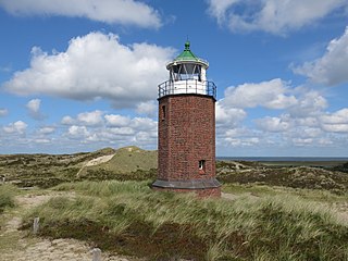
The Rotes Kliff Lighthouse on the island of Sylt, Germany, served as a sector light from 1913 to 1975. It is located on a cliffside north of the village of Kampen.
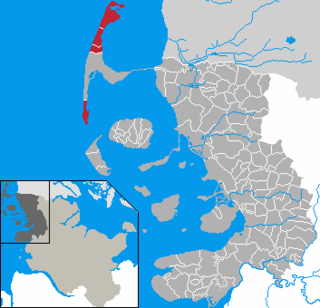
Gemeinde Sylt is a municipality on the island of Sylt in the district of Nordfriesland, in Schleswig-Holstein, Germany. It has around 13,000 inhabitants and covers about 60% of the area of the island.
Ekke Nekkepenn is a North German legendary figure. In the middle of the 19th century, the local researcher, folklorist, and graphic artist Christian Peter Hansen (1803–1879) portrayed Ekke Nekkepenn as a merman who lives with his wife Rahn at the bottom of the North Sea and plays mischievous tricks on seafarers and residents of the North Frisian Islands. In Theodor Storm’s 1866 published fairy tale "The Rain Maiden", a little man of fire with the name Eckeneckenpen appears and casts evil spells to make the fields wither.

Archsum is a village on the North Sea island of Sylt in the district of Nordfriesland in Schleswig-Holstein, Germany. Today, it is an Ortsteil of the Gemeinde Sylt.
Morsum is a village on the North Sea island of Sylt in the district of Nordfriesland in Schleswig-Holstein, Germany. Today, it is an Ortsteil of the Gemeinde Sylt. Morsum is located close to the scientifically important geotope Morsum-Kliff and to the beginning of the Hindenburgdamm linking Sylt with the mainland.

Tinnum is a village on the North Sea island of Sylt in the district of Nordfriesland in Schleswig-Holstein, Germany. Today, it is an Ortsteil of the Gemeinde Sylt.

Keitum is a village on the North Sea island of Sylt in the district of Nordfriesland in Schleswig-Holstein, Germany. Today, it is an Ortsteil of the Gemeinde Sylt.

Franz Korwan, born Sally Katzenstein was a German-Jewish landscape painter and Kommunalpolitiker on the island of Sylt. He was associated with the Düsseldorfer Malerschule. Sally is the familiar form of Salomon. His name change was legally recognized in 1924.


