Nordfriesland (district)

Last updated • 2 min readFrom Wikipedia, The Free Encyclopedia
Nordfriesland
Flagge Kreis Nordfriesland.svg
DEU Kreis Nordfriesland COA.svg
Schleswig-Holstein NF.svg
Country Germany
State Schleswig-Holstein
Capital Husum
Government
  District admin.Florian Lorenzen (CDU)
Area
  Total2,047 km2 (790 sq mi)
Population
 (31 December 2022) [1]
  Total169,043
  Density83/km2 (210/sq mi)
Time zone UTC+01:00 (CET)
  Summer (DST) UTC+02:00 (CEST)
Vehicle registration NF
Website nordfriesland.de
Marshland in Eiderstedt, typical of the North Frisian coast Eiderstedt-marshland.jpg
Marshland in Eiderstedt, typical of the North Frisian coast
Horsecart coming from a Hallig island in the mudflat at low tide Hallig Suedfall2.JPG
Horsecart coming from a Hallig island in the mudflat at low tide

Nordfriesland (German pronunciation: [nɔʁtˈfʁiːslant] ; Danish : Nordfrisland; North Frisian : Nordfraschlönj [nɔʀdˈfʀaʃlœɲ] Low German: Noordfreesland), also known as North Frisia, is the northernmost district of Germany, part of the state of Schleswig-Holstein. It includes almost all of traditional North Frisia (with the exception of the island of Heligoland), as well as adjacent parts of the Schleswig Geest to the east and Stapelholm to the south, and is bounded (from the east and clockwise) by the districts of Schleswig-Flensburg and Dithmarschen, the North Sea and the Danish county of South Jutland. The district is called Kreis Nordfriesland in German, Kreis Noordfreesland in Low German, Kris Nordfraschlönj in Mooring North Frisian, Kreis Nuurdfresklun in Fering North Frisian and Nordfrislands amt in Danish.

Contents

As of 2008, Nordfriesland was the most visited rural district in Germany. [2]

History

The sea has always had a strong influence in the region. In medieval times, storm tides made life in what is now Nordfriesland rather dangerous. Only in modern times was the loss of land and lives able to be stopped by building solid dikes. Many villages that once existed are now at the bottom of the sea. The best-known example is the small seaport of Rungholt, which was destroyed by a storm surge in 1362. The island of Strand vanished in the Burchardi flood, another disastrous storm in 1634. Subsequent to this storm surge, there were many small islets instead of Strand.

From approximately 1200 until 1864, the area that is now Nordfriesland was a part of the Duchy of Schleswig, which itself was not directly a part of the Danish Kingdom, but a fiefdom of the Danish crown and linked to the kings of Denmark by personal union as a separate entity. Nordfriesland is still a multilingual district: there are people speaking standard German, Low German, North Frisian and Danish including South Jutlandic. The North Frisian language exists in nine slightly different dialects, yet it is mainly used by older citizens in mainland Nordfriesland. A relatively lively community of Frisian speakers exists though on the islands of Föhr and Amrum. After becoming German, three districts were established in the region: Südtondern in the north, Husum in the centre, and Eiderstedt in the south. In 1970 these three districts were merged to form the Nordfriesland district.

Geography

North Frisia within the modern Nordfriesland district. KreisRegionNordfriesland.png
North Frisia within the modern Nordfriesland district.

The entire coastal region is part of the Schleswig-Holstein Wadden Sea National Park. Nordfriesland includes the coastal section between Dithmarschen and Denmark. In the south is the Eiderstedt peninsula, where the River Eider meets the sea.

The North Frisian Islands are also part of the Nordfriesland district and located inside the national park as well. There are five large islands (Sylt, Föhr, Amrum, Pellworm and Nordstrand) and ten smaller islets known as Halligen.

Coat of arms

DEU Kreis Nordfriesland COA.svg
The coat of arms displays three golden ships on a blue background. These coats of arms have been used by the Eiderstedt peninsula since the 17th century. When the district was established in 1970, the arms of Eiderstedt were applied to the entire district. Differing from the old arms, though, there are three images visible on the ships' sails: a plow, a herring and a bull's head.

Towns and municipalities

Uebersicht-NF.png
Independent towns and municipalities
  1. Friedrichstadt
  2. Husum
  3. Tönning
  4. Reußenköge
Ämter
  1. Garding 1, 2
  2. Garding, Kirchspiel
  3. Grothusenkoog
  4. Katharinenheerd
  5. Kotzenbüll
  6. Norderfriedrichskoog
  7. Oldenswort
  8. Osterhever
  9. Poppenbüll
  10. Sankt Peter-Ording
  11. Tating
  12. Tetenbüll
  13. Tümlauer-Koog
  14. Vollerwiek
  15. Welt
  16. Westerhever
  1. Alkersum
  2. Borgsum
  3. Dunsum
  4. Midlum
  5. Nebel
  6. Nieblum
  7. Norddorf
  8. Oevenum
  9. Oldsum
  10. Süderende
  11. Utersum
  12. Witsum
  13. Wittdün
  14. Wrixum
  15. Wyk auf Föhr 1, 2
  1. Hörnum
  2. Kampen
  3. List
  4. Sylt 1
  5. Wenningstedt-Braderup
  1. Ahrenshöft
  2. Almdorf
  3. Bargum
  4. Bohmstedt
  5. Bordelum
  6. Bredstedt 1, 2
  7. Breklum
  8. Drelsdorf
  9. Goldebek
  10. Goldelund
  11. Högel
  12. Joldelund
  13. Kolkerheide
  14. Langenhorn
  15. Lütjenholm
  16. Ockholm
  17. Sönnebüll
  18. Struckum
  19. Vollstedt
  1. Arlewatt
  2. Drage
  3. Elisabeth-Sophien-Koog
  4. Fresendelf
  5. Hattstedt
  6. Hattstedtermarsch
  7. Horstedt
  8. Hude
  9. Koldenbüttel
  10. Mildstedt 1
  11. Nordstrand
  12. Oldersbek
  13. Olderup
  14. Ostenfeld
  15. Ramstedt
  16. Rantrum
  17. Schwabstedt
  18. Seeth
  19. Simonsberg
  20. Süderhöft
  21. Südermarsch
  22. Uelvesbüll
  23. Winnert
  24. Wisch
  25. Wittbek
  26. Witzwort
  27. Wobbenbüll
  1. Gröde
  2. Hooge
  3. Langeneß
  4. Pellworm 1
  1. Achtrup
  2. Aventoft
  3. Bosbüll
  4. Braderup
  5. Bramstedtlund
  6. Dagebüll
  7. Ellhöft
  8. Emmelsbüll-Horsbüll
  9. Enge-Sande
  10. Friedrich-Wilhelm-Lübke-Koog
  11. Galmsbüll
  12. Holm
  13. Humptrup
  14. Karlum
  15. Klanxbüll
  16. Klixbüll
  17. Ladelund
  18. Leck
  19. Lexgaard
  20. Neukirchen
  21. Niebüll 1, 2
  22. Risum-Lindholm
  23. Rodenäs
  24. Sprakebüll
  25. Stadum
  26. Stedesand
  27. Süderlügum
  28. Tinningstedt
  29. Uphusum
  30. Westre
  1. Ahrenviöl
  2. Ahrenviölfeld
  3. Behrendorf
  4. Bondelum
  5. Haselund
  6. Immenstedt
  7. Löwenstedt
  8. Norstedt
  9. Oster-Ohrstedt
  10. Schwesing
  11. Sollwitt
  12. Viöl 1
  13. Wester-Ohrstedt
1seat of the Amt; 2town

See also

Related Research Articles

<span class="mw-page-title-main">Frisian languages</span> Group of Germanic languages

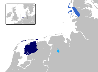
The Frisian languages are a closely related group of West Germanic languages, spoken by about 400,000 Frisian people, who live on the southern fringes of the North Sea in the Netherlands and Germany. The Frisian languages are the closest living language group to the Anglic languages; the two groups make up the Anglo-Frisian languages group and together with the Low German dialects these form the North Sea Germanic languages. However, modern English and Frisian are not mutually intelligible, nor are Frisian languages intelligible among themselves, owing to independent linguistic innovations and language contact with neighboring languages.

<span class="mw-page-title-main">North Frisian Islands</span> Islands in Germany

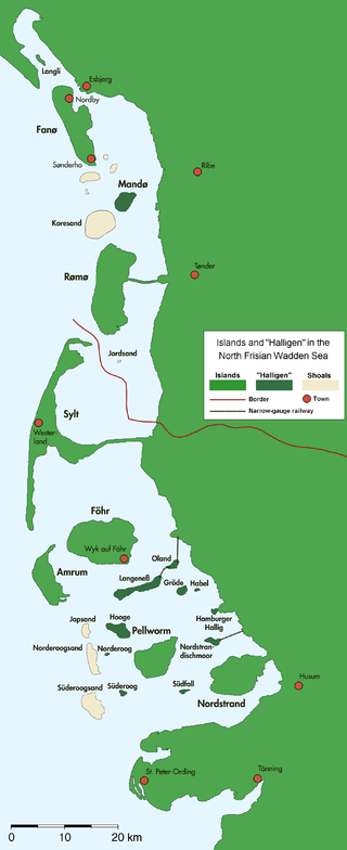
The North Frisian Islands are the Frisian Islands off the coast of North Frisia.

<span class="mw-page-title-main">Schleswig-Flensburg</span> District in Schleswig-Holstein, Germany

Schleswig-Flensburg is a district in Schleswig-Holstein, Germany. It is bounded by the districts of Rendsburg-Eckernförde, Dithmarschen and Nordfriesland, the Region Syddanmark in Denmark, the city of Flensburg and the Baltic Sea.

<span class="mw-page-title-main">Föhr</span> Island in Schleswig-Holstein, Germany

Föhr is one of the North Frisian Islands on the German coast of the North Sea. It is part of the Nordfriesland district in the federal state of Schleswig-Holstein. Föhr is the second-largest North Sea island of Germany and a popular destination for tourists. A town and eleven distinct municipalities are located on the island. The climate is oceanic with moderate winters and relatively cool summers.

<span class="mw-page-title-main">Amrum</span> German island

Amrum is one of the North Frisian Islands on the German North Sea coast, south of Sylt and west of Föhr. It is part of the Nordfriesland district in the federal state of Schleswig-Holstein and has approximately 2,300 inhabitants.

<span class="mw-page-title-main">Nordstrand, Germany</span> Municipality in Schleswig-Holstein, Germany

is a peninsula and former island in North Frisia on the North Sea coast of Germany. It is part of the Nordfriesland district in the federal state of Schleswig-Holstein. Its area is 50 km² and its population is 2,300. Nordstrand has two municipalities, Nordstrand and smaller Elisabeth-Sophien-Koog, which are part of the Amt Nordsee-Treene.

<span class="mw-page-title-main">North Frisian language</span> Minority language of Germany, spoken mostly by people in North Frisia

North Frisian is a minority language of Germany, spoken by about 10,000 people in North Frisia. The language is part of the larger group of the West Germanic Frisian languages. The language comprises 10 dialects which are themselves divided into an insular and a mainland group.

<span class="mw-page-title-main">Dagebüll</span> Municipality in Schleswig-Holstein, Germany

Dagebüll is a municipality located at the west coast of Schleswig-Holstein in the Nordfriesland district, Germany. Today's Dagebüll was created in 1978 as a merger of the municipalities of Fahretoft, Juliane-Marien-Koog and Waygaard. Dagebüll used to be a Hallig, the oldest houses were built on artificial dwelling hills which in parts can still be seen today. In 1704 the area was secured by sea dikes.

<span class="mw-page-title-main">Eiderstedt</span>

Eiderstedt is a peninsula in the district of Nordfriesland in the German federal state of Schleswig-Holstein.

<span class="mw-page-title-main">North Frisia</span> Place in Schleswig-Holstein, Germany

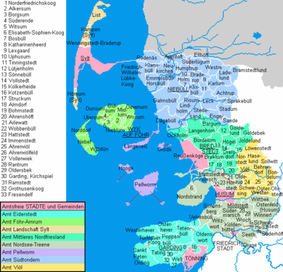
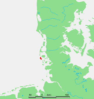
North Frisia is the northernmost portion of Frisia, located in Schleswig-Holstein, Germany, between the rivers Eider and Wiedau. It also includes the North Frisian Islands and Heligoland. The region is traditionally inhabited by the North Frisians.

<span class="mw-page-title-main">Wyk auf Föhr</span> Town in Schleswig-Holstein, Germany

Wyk auf Föhr is the only town on Föhr, the second largest of the North Frisian Islands on the German coast of the North Sea. Like the entire island it belongs to the district of Nordfriesland. Wyk includes the two minor town districts of Boldixum and Südstrand.

<span class="mw-page-title-main">Dunsum</span> Municipality in Schleswig-Holstein, Germany

Dunsum is a municipality located on the western shore of Föhr in the district of Nordfriesland, in Schleswig-Holstein, Germany. It is composed of the districts of Greater and Lesser Dunsum.

<span class="mw-page-title-main">Norddorf</span> Municipality in Schleswig-Holstein, Germany

Norddorf auf Amrum is a municipality on the island of Amrum, in the district of Nordfriesland, in Schleswig-Holstein, Germany.

<span class="mw-page-title-main">Utersum</span> Municipality in Schleswig-Holstein, Germany

Utersum is a municipality on the island of Föhr, in the district of Nordfriesland, in Schleswig-Holstein, Germany. The municipality includes the hamlet of Hedehusum.

<span class="mw-page-title-main">Witsum</span> Municipality in Schleswig-Holstein, Germany

Witsum is a municipality on the island of Föhr, in the district of Nordfriesland, in Schleswig-Holstein, Germany.

<span class="mw-page-title-main">Wittdün</span> Municipality in Schleswig-Holstein, Germany

Wittdün is a municipality on the island of Amrum in the district of Nordfriesland in Schleswig-Holstein, Germany.

<span class="mw-page-title-main">North Frisians</span>

North Frisians are the inhabitants of the district of Nordfriesland in the north German state of Schleswig-Holstein. Used in a narrower sense, the term also refers to an ethnic sub-group of the Frisians from the region of North Frisia, which lies primarily on the German North Sea coast, and on the island of Heligoland.

<span class="mw-page-title-main">Tourism in Schleswig-Holstein</span>

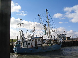
Tourism is an important economic factor for Germany's northernmost state of Schleswig-Holstein.

<span class="mw-page-title-main">Uthlande</span> Historical region in Germany and Denmark

Uthlande, Utlande is a term for the islands, halligen and marshes off the mainland of North Frisia in the Southwest Jutland, modern Nordfriesland district, Germany.

References

  1. "Bevölkerung der Gemeinden in Schleswig-Holstein 4. Quartal 2022" (XLS) (in German). Statistisches Amt für Hamburg und Schleswig-Holstein.
  2. "Tourismus- und Hotelatlas 2009-2010" (PDF) (in German). Georg & Ottenströer. p. 8. Archived (PDF) from the original on 2022-10-09.[ permanent dead link ]

54°35′N9°00′E / 54.58°N 9.0°E / 54.58; 9.0