
Schleswig-Holstein is the northernmost of the 16 states of Germany, comprising most of the historical Duchy of Holstein and the southern part of the former Duchy of Schleswig. Its capital city is Kiel; other notable cities are Lübeck and Flensburg. It covers an area of 15,763 km2 (6,086 sq mi), making it the 5th smallest German federal state by area. Historically, the name can also refer to a larger region, containing both present-day Schleswig-Holstein and the former South Jutland County in Denmark.
Ostholstein is a district in Schleswig-Holstein, Germany. It is bounded by the districts of Stormarn, Segeberg and Plön, the Baltic Sea and the city of Lübeck. Geographically, the district covers the vast majority of what is considered to be the peninsular of Wagria.

Fehmarn is an island in the Baltic Sea, off the eastern coast of Germany's northernmost state of Schleswig-Holstein. It is Germany's third-largest island, after Rügen and Usedom. Fehmarn is separated from the German peninsula of Wagria in Holstein by the Fehmarn Sound, and from the southern Danish island of Lolland by the Fehmarn Belt. It is connected to the Holsatian mainland by the Fehmarn Sound Bridge. The island belongs to the district of Ostholstein. The closest larger towns on the mainland are Heiligenhafen and Oldenburg in Holstein. Right opposite Fehmarn, on the tip of the Wagrian Peninsula, is Großenbrode.

Angeln is a peninsula on the Baltic coast of Jutland, in the Bay of Kiel. It forms part of Southern Schleswig, the northernmost region of Germany. The peninsula is bounded on the north by the Flensburg Firth, which separates it from Sundeved and the island of Als in Denmark, and on the south by the Schlei, which separates it from Schwansen. The landscape is hilly, dotted with numerous lakes. The largest towns are Flensburg, Schleswig and Kappeln.

is a municipality in the district of Nordfriesland, in Schleswig-Holstein, Germany.

The Bay of Lübeck is a basin in the southwestern Baltic Sea, off the shores of the German states of Mecklenburg-Vorpommern and Schleswig-Holstein. It forms the southwestern part of the Bay of Mecklenburg.

The Bay of Kiel or Kiel Bay is a bay in the southwestern Baltic Sea, off the shores of Schleswig-Holstein in Germany and the islands of Denmark. It is connected with the Bay of Mecklenburg in the east, the Little Belt in the northwest, and the Great Belt in the North.

Als is a Danish island in the Baltic Sea.

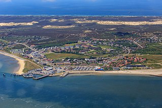
Eiderstedt is a peninsula in the district of Nordfriesland in the German federal state of Schleswig-Holstein.

Neustadt in Holstein is a town in the district of Ostholstein, in Schleswig-Holstein, Germany, on the Bay of Lübeck 30 km northeast of Lübeck, and 50 km southeast of Kiel.
List auf Sylt is the northernmost municipality in Germany, located on the North Sea island of Sylt close to Denmark in the district of Nordfriesland in the state of Schleswig-Holstein.

Eckernförde Bay is a firth and a branch of the Bay of Kiel between the Danish Wahld peninsula in the south and the Schwansen peninsula in the north in the Baltic Sea off the lands of Schleswig-Holstein, Germany. The bay extends around 17 km (11 mi) deep into the land and is 10 km (6.2 mi) wide at its entrance where Booknis-Eck and Danish-Nienhof mark the endpoints. The bay is up to 28 m (92 ft) deep. The border to the Kiel Fjord lies at the Bülk Lighthouse. The once forested Danish Wahld peninsula between Kiel Fjord and Eckernförde Bay constituted the borderland between the Saxons and the Danes until the Middle Ages. At the inner end of the bay lies the town of Eckernförde.

is a municipality in the district of Nordfriesland, in Schleswig-Holstein, Germany. It is located on the southern headland of the island of Sylt. The municipality is part of the Amt Landschaft Sylt. The economy is dominated by tourism.

Tetenbüll is a municipality in the district of Nordfriesland, in Schleswig-Holstein, Germany.

Behrensdorf is a municipality in the district of Plön, in Schleswig-Holstein, Germany. It lies on the western shore of Hohwacht Bay on the Baltic Sea coast. About one kilometre to the north is the eighty-year-old Neuland Lighthouse.
Jutland is a peninsula of Northern Europe that forms the continental portion of Denmark and part of northern Germany (Schleswig-Holstein). It stretches from the Grenen spit in the north to the confluence of the Elbe and the Sude in the southeast. The historic southern border river of Jutland as a cultural-geographical region, which historically also included Southern Schleswig, is the Eider. The peninsula, on the other hand, also comprises areas south of the Eider: Holstein, the former duchy of Lauenburg, and most of Hamburg and Lübeck.

Eiderstedt is an Amt in the district of Nordfriesland, in Schleswig-Holstein, Germany. The Amt covers the peninsula of Eiderstedt, excepted for the town of Tönning.
The Wadden Sea Conservation Station is a non-profit, NGO in North Germany. The organisation was founded in 1962 and, since then, has been one of the official NGO partners of the Wadden Sea National Parks. Today the conservation group employs over 100 young people, both volunteers and paid workers, at its headquarters in Husum and the 17 stations on the westcoast of Schleswig-Holstein.

Uthlande, Utlande is a term for the islands, halligen and marshes off the mainland of North Frisia in the Southwest Jutland, modern Nordfriesland district, Germany.
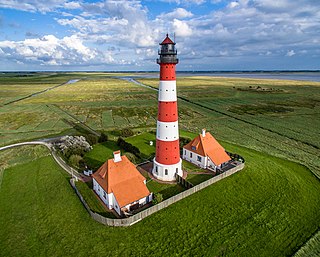
The Westerheversand Lighthouse is located in Westerhever, Schleswig-Holstein, Germany. Considered to be one of the best-known lighthouses in northern Germany, it was built in 1908. Its cast iron tower is 40 metres (130 ft) high. The lighthouse is often used for weddings, and one of the two keeper's cottages has been adapted for use by the local registrar.


