Related Research Articles
The Mesoproterozoic Era is a geologic era that occurred from 1,600 to 1,000 million years ago. The Mesoproterozoic was the first era of Earth's history for which a fairly definitive geological record survives. Continents existed during the preceding era, but little is known about them. The continental masses of the Mesoproterozoic were more or less the same ones that exist today, although their arrangement on the Earth's surface was different.

Earth's crust is a thin shell on the outside of Earth, accounting for less than 1% of Earth's volume. It is the top component of the lithosphere, a division of Earth's layers that includes the crust and the upper part of the mantle. The lithosphere is broken into tectonic plates whose motion allows heat to escape from the interior of the Earth into space.

The Grenville orogeny was a long-lived Mesoproterozoic mountain-building event associated with the assembly of the supercontinent Rodinia. Its record is a prominent orogenic belt which spans a significant portion of the North American continent, from Labrador to Mexico, as well as to Scotland.
The Napier Mountains are a group of close set peaks, the highest being Mount Elkins, at about 2,300 meters above sea level. This mountain range is located in Enderby Land, in the claimed Australian Antarctic Territory, East Antarctica.

The Musgrave Block is an east-west trending belt of Proterozoic granulite-gneiss basement rocks approximately 500 kilometres (310 mi) long. The Musgrave Block extends from western South Australia into Western Australia.

The Kalahari Craton is a craton, an old and stable part of the continental lithosphere, that occupies large portions of South Africa, Botswana, Namibia and Zimbabwe. It consists of two cratons separated by the Limpopo Belt: the larger Kaapvaal Craton to the south and the smaller Zimbabwe Craton to the north. The Namaqua Belt is the southern margin of the Kaapvaal Craton.

The North China Craton is a continental crustal block with one of Earth's most complete and complex records of igneous, sedimentary and metamorphic processes. It is located in northeast China, Inner Mongolia, the Yellow Sea, and North Korea. The term craton designates this as a piece of continent that is stable, buoyant and rigid. Basic properties of the cratonic crust include being thick, relatively cold when compared to other regions, and low density. The North China Craton is an ancient craton, which experienced a long period of stability and fitted the definition of a craton well. However, the North China Craton later experienced destruction of some of its deeper parts (decratonization), which means that this piece of continent is no longer as stable.
The Alice Springs Orogeny was a major intraplate tectonic episode in central Australia responsible for the formation of a series of large mountain ranges. The deformation associated with the Alice Spring Orogeny caused the vertically-tilted sandstone layers of the iconic Uluru/Ayers Rock.

The Wyoming Craton is a craton in the west-central United States and western Canada – more specifically, in Montana, Wyoming, southern Alberta, southern Saskatchewan, and parts of northern Utah. Also called the Wyoming Province, it is the initial core of the continental crust of North America.
In geology ultrahigh-temperature metamorphism (UHT) is extreme crustal metamorphism with metamorphic temperatures exceeding 900 °C. Granulite-facies rocks metamorphosed at very high temperatures were identified in the early 1980s, although it took another decade for the geoscience community to recognize UHT metamorphism as a common regional phenomenon. Petrological evidence based on characteristic mineral assemblages backed by experimental and thermodynamic relations demonstrated that Earth's crust can attain and withstand very high temperatures (900–1000 °C) with or without partial melting.
The West African Craton (WAC) is one of the five cratons of the Precambrian basement rock of Africa that make up the African Plate, the others being the Kalahari craton, Congo craton, Saharan Metacraton and Tanzania Craton. Cratons themselves are tectonically inactive, but can occur near active margins, with the WAC extending across 14 countries in Western Africa, coming together in the late Precambrian and early Palaeozoic eras to form the African continent. It consists of two Archean centers juxtaposed against multiple Paleoproterozoic domains made of greenstone belts, sedimentary basins, regional granitoid-tonalite-trondhjemite-granodiorite (TTG) plutons, and large shear zones. The craton is overlain by Neoproterozoic and younger sedimentary basins. The boundaries of the WAC are predominantly defined by a combination of geophysics and surface geology, with additional constraints by the geochemistry of the region. At one time, volcanic action around the rim of the craton may have contributed to a major global warming event.

The Algoman orogeny, known as the Kenoran orogeny in Canada, was an episode of mountain-building (orogeny) during the Late Archean Eon that involved repeated episodes of continental collisions, compressions and subductions. The Superior province and the Minnesota River Valley terrane collided about 2,700 to 2,500 million years ago. The collision folded the Earth's crust and produced enough heat and pressure to metamorphose the rock. Blocks were added to the Superior province along a 1,200 km (750 mi) boundary that stretches from present-day eastern South Dakota into the Lake Huron area. The Algoman orogeny brought the Archean Eon to a close, about 2,500 million years ago; it lasted less than 100 million years and marks a major change in the development of the Earth's crust.
The North Atlantic Craton (NAC) is an Archaean craton exposed in southern West Greenland, the Nain Province in Labrador, and the Lewisian complex in northwestern Scotland. The NAC is bounded by the Nagssugtoqidian orogen to the north and the 1.8–1.87 Ga Ketilidan–Makkovik mobile belt to the south. The latter can be linked to the Lewisian-Malin boundary in Scotland, which in turn can be linked to the Transscandinavian Igneous Belt in Baltica.
The Grenville Province is a tectonically complex region, in Eastern Canada, that contains many different aged accreted terranes from various origins. It exists southeast of the Grenville Front and extends from Labrador southwestern to Lake Huron. It is bounded by the St. Lawrence River/Seaway to the southeast.
The geology of Brazil includes very ancient craton basement rock from the Precambrian overlain by sedimentary rocks and intruded by igneous activity, as well as impacted by the rifting of the Atlantic Ocean.

The Eastern Block of the North China Craton is one of the Earth's oldest pieces of continent. It is separated from the Western Block by the Trans-North China Orogen. It is situated in northeastern China and North Korea. The Block contains rock exposures older than 2.5 billion years. It serves as an ideal place to study how the crust was formed in the past and the related tectonic settings.
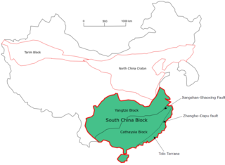
The South China Craton or South China Block is one of the Precambrian continental blocks in China. It is traditionally divided into the Yangtze Block in the NW and the Cathaysia Block in the SE. The Jiangshan–Shaoxing Fault represents the suture boundary between the two sub-blocks. Recent study suggests that the South China Block possibly has one more sub-block which is named the Tolo Terrane. The oldest rocks in the South China Block occur within the Kongling Complex, which yields zircon U–Pb ages of 3.3–2.9 Ga.
The Superior Craton is a stable crustal block covering Quebec, Ontario, and southeast Manitoba in Canada, and northern Minnesota in the United States. It is the biggest craton among those formed during the Archean period. A craton is a large part of the Earth's crust that has been stable and subjected to very little geological changes over a long time. The size of Superior Craton is about 1,572,000 km2. The craton underwent a series of events from 4.3 to 2.57 Ga. These events included the growth, drifting and deformation of both oceanic and continental crusts.
The Mangaroon orogeny was an orogenic event in what is now Western Australia between 1.68 and 1.62 billion years ago in the Proterozoic, preserved in the rocks of the large Gascoyne Province.
The Picuris orogeny was an orogenic event in what is now the Southwestern United States from 1.43 to 1.3 billion years ago in the Calymmian Period of the Mesoproterozoic. The event is named for the Picuris Mountains in northern New Mexico and interpreted either as the suturing of the Granite-Rhyolite crustal province to the southern margin of the proto-North American continent Laurentia or as the final suturing of the Mazatzal crustal province onto Laurentia. According to the former hypothesis, this was the second in a series of orogenies within a long-lived convergent boundary along southern Laurentia that ended with the ca. 1200–1000 Mya Grenville orogeny during the final assembly of the supercontinent Rodinia, which ended an 800-million-year episode of convergent boundary tectonism.
References
- ↑ Kirkland, C.L. and co-authors (2013). "Constraints and deception in the isotopic record; the crustal evolution of the west Musgrave Province, central Australia". Gondwana Research. 23 (2): 759–781. Bibcode:2013GondR..23..759K. doi:10.1016/j.gr.2012.06.001.
- ↑ Smithies, R.H. and co-authors (2011). "High-Temperature Granite Magmatism, Crust–Mantle Interaction and the Mesoproterozoic Intracontinental Evolution of the Musgrave Province, Central Australia". Journal of Petrology. IEEE-OUP. 52 (5): 1. doi: 10.1093/petrology/egr010 .
| | This article about a regional geological feature is a stub. You can help Wikipedia by expanding it. |
| | This Australia-related article is a stub. You can help Wikipedia by expanding it. |