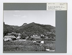
Nada, Kentucky

Last updated

Nada
Towns and Cities- Occupied - Kentucky - DPLA - df51c4eb9ae2ba19c7f6fa4047a9c2da.jpg
Nada in 1968
USA Kentucky location map.svg
Red pog.svg
Nada
Location within the state of Kentucky
Usa edcp location map.svg
Red pog.svg
Nada
Nada (the United States)
Coordinates: 37°48′55″N83°43′13″W / 37.81528°N 83.72028°W / 37.81528; -83.72028
Country United States
State Kentucky
County Powell
Elevation
689 ft (210 m)
Population
 (2010)
  Total
52
Time zone UTC-5 (Eastern (EST))
  Summer (DST) UTC-5 (EST)
GNIS feature ID2420683 [1]

Nada is an unincorporated community in Powell County, Kentucky, United States.

History

Nada had its start in the year 1911 when the railroad was extended to that point; a sawmill was built there the same year. [2] The community lent its name to the nearby Nada Tunnel, originally a railroad tunnel completed in 1911. [3] The post office serving Nada was called Lombard. [2] This post office was established in 1901, and remained in operation until 1968. [4]

References

  1. U.S. Geological Survey Geographic Names Information System: Nada, Kentucky
  2. 1 2 Rennick, Robert M. Kentucky Place Names. University Press of Kentucky. p. 209. ISBN   0-8131-2631-2.
  3. Kappele, William; Kappele, Cora (April 1, 2000). Scenic Driving Kentucky. Globe Pequot Press. p. 45. ISBN   978-1-56044-733-7.
  4. "Powell County". Jim Forte Postal History. Retrieved September 28, 2014.