
Dadra and Nagar Haveli is a district of the Indian union territory of Dadra and Nagar Haveli and Daman and Diu in western India. It is composed of two separate geographical entities: Nagar Haveli, wedged between Maharashtra and Gujarat and 1 kilometre (0.62 mi) to the northwest, the smaller enclave of Dadra, which is surrounded by Gujarat. Silvassa is the administrative headquarters of Dadra and Nagar Haveli.

Thane district is a district in the Indian state of Maharashtra in Konkan Division. At the 2011 Census it was the most populated district in the nation, with 11,060,148 inhabitants; however, in August 2014 the district was split into two with the creation of a new Palghar district, leaving the reduced Thane district with a 2011 Census population of 8,070,032. The headquarters of the district is the city of Thane. Other major cities in the district are Navi Mumbai, Kalyan-Dombivli, Mira-Bhayander, Bhiwandi, Ulhasnagar, Ambarnath, Badlapur, Murbad and Shahapur.
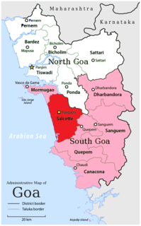
Salcete, also spelt as Salcette, is an area situated in southern portion of Goa state, on the west coast of India.

North Goa is one of the two districts that make up the state of Goa in India. The district has an area of 1736 km², and is bounded by Kolhapur district and Sindhudurg district of Maharashtra state to the north and by Belgaum district of Karnataka to the east, by South Goa district to the south, and by the Arabian Sea to the west.

South Goa is one of two districts that comprises the state of Goa in India, within the region known as the Konkan. It is bounded by North Goa district to the north, the Uttara Kannada district of Karnataka state to the east and south, while the Arabian Sea forms its western coast.

Bardez is a region situated in the northern portion of the state of Goa, India. It is co-terminus with the eponymous taluka of the district of North Goa.
The administrative divisions of India are subnational administrative units of India; they are composed of a nested hierarchy of country subdivisions.

Saligão is a census town in North Goa district in the Indian state of Goa. It is surrounded by the villages of Porvorim, Parra, Guirim, Sangolda, Pilerne, Candolim, Calangute and Nagoa and is in Bardez Taluka of Goa. It is 10 km from Panjim the capital of Goa, 6 km from Mapusa the capital of Bardez Taluka, and 3 km from the Calangute beach.

The Kali River or Kaali Nadi is a river flowing through Uttara Kannada district of Karnataka state in India. The river rises near Kushavali, a small village in Uttar Kannada district. The river is the lifeline to some 400,000 people in the Uttara Kannada district and supports the livelihoods of tens of thousands of people including fishermen on the coast of Karwar. There are many dams built across this river for the generation of electricity. One of the important dams build across Kali river is the Supa Dam at Ganeshgudi. The river runs 184 kilometers before joining Arabian Sea.
Raia (Rai) is a scenic village on the outskirts of Margao in Salcete Taluk in South Goa District of Goa State, India. It is located six kilometres east from the district headquarters of Margao and 35 kilometres from the State capital Panaji.

Pondataluka is a subdivision of the district of North Goa, Goa state, India. Its administrative headquarters is the township of Ponda.
Pilerne is a village situated in north Goa in the Bardez taluka of the North Goa district. It is rustic despite being fairly close to the North Goa tourist belt, and is considered a Census Town for the purposes of the Census. The village has mainly been inhabited by Goan Catholics.
Calvim is an island village situated in the Bardez sub-district or taluka of Goa. It is in the vicinity of the prominent Aldona village.
Usgao is a village in Ponda taluka, North Goa district, India.
Oxel is a village in Bardez sub-district, North Goa, India. The nearest airport is Dabolim Airport and railway station is at Tivim. Oxel has been described as a "picturesque village" and is located in North Goa's Bardez sub-district or taluka. Oxel is a small, green and water-surrounded village. It is located approximately 25 km (16 mi) away from the State capital Panjim or Panaji. Its panchayat puts down its area to around 2.8 km2 (1.1 sq mi).
Pirna is a village in the North Goa sub-district or taluka of Bardez and is located in the northern edge of the sub-district. It is close to the Colvale river and is the home of the 150-metre long Pirna-Ozarim bridge at Thorli Chandai. The bridge connects Pirna in Bardez taluka with Pernem taluka. It was inaugurated in May 2006.
Punola is a small village or hamlet in the North Goa sub-district or taluka of Bardez. It is near the village panchayat of Ucassaim, and St. Elizabeth's Church lies just outsides its boundaries.
Betqui or Betki is a village in the Ponda taluka (sub-district) of Goa.
Boma is a village in the Ponda taluka (sub-district) of Goa. It is located in the northern part of Ponda taluka. It is on the road connecting state capital Panjim with the taluka headquarters of Ponda town.
Codar is a village in the Ponda taluka (sub-district) of Goa. Codar, also spelt as Kodar, is home to the Goa Government Agricultural Farm.

