Nadorah | |
|---|---|
Commune and town | |
| Country | |
| Province | Tiaret Province |
| Population (1998) | |
| • Total | 7,030 |
| Time zone | UTC+1 (CET) |
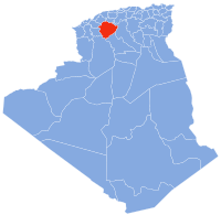
Nadorah is a town and commune in Tiaret Province, Algeria. According to the 1998 census it has a population of 7,030. [1]
Nadorah | |
|---|---|
Commune and town | |
| Country | |
| Province | Tiaret Province |
| Population (1998) | |
| • Total | 7,030 |
| Time zone | UTC+1 (CET) |
Nadorah is a town and commune in Tiaret Province, Algeria. According to the 1998 census it has a population of 7,030. [1]
Concordia is a city and its surrounding municipality in the Mexican state of Sinaloa. The town is noted for manufacture of artesinal wooden furniture, symbolized by the giant chair in the town plaza. According to 2010 census, it had a population of 8,328 inhabitants.

Kalihi is a neighborhood of Honolulu on the island of Oʻahu in Hawaiʻi, United States. Split by the Likelike Highway, it is flanked by downtown Honolulu to the east and Mapunapuna, Moanalua and Salt Lake to the west.

Ardagh is a townland in the fertile district known as the Laggan in East Donegal, part of County Donegal, Ireland. It is very near St. Johnston. It became part of the large Abercorn Estate and was settled by mainly Lowland Scots settlers during the Plantation of Ulster.

Grubville is an unincorporated community in western Jefferson County, Missouri, United States. It is located approximately one-half mile east of the Jefferson/Franklin County line. Missouri routes WW and Y meet at the community and Route 30 passes approximately one mile to the north. Nearby communities include Dittmer and Morse Mill to the east and Lonedell and Luebbering to the west in Franklin County. Jones Creek flows from the east side of the community to its confluence with Big River approximately five miles to the east.

Owego Township is located in Livingston County, Illinois. As of the 2010 census, its population was 328 and it contained 123 housing units.
Glušci is a village in Serbia. It is situated in the Bogatić municipality, in the Mačva District. The village has a Serb ethnic majority and its population numbering 2,346 people.
Rabbs Prairie is an unincorporated community in Fayette County, Texas, United States.

Stary Dwór is a village in the administrative district of Gmina Narewka, within Hajnówka County, Podlaskie Voivodeship, in north-eastern Poland, close to the border with Belarus.
Xıdırlı is a village in the Agdam District of Azerbaijan.
Takkar is a village and union council of Mardan District in Khyber Pakhtunkhwa province of Pakistan. It is located at 34°17′18N 71°53′50E and has an altitude of 338 metres (1,109 ft).
Przodkowo-Wybudowanie is a village in the administrative district of Gmina Przodkowo, within Kartuzy County, Pomeranian Voivodeship, in northern Poland. It lies approximately 2 kilometres (1 mi) north of Przodkowo, 9 km (6 mi) north-east of Kartuzy, and 23 km (14 mi) west of the regional capital Gdańsk.
Smoląg is a village in the administrative district of Gmina Bobowo, within Starogard County, Pomeranian Voivodeship, in northern Poland. It lies approximately 3 kilometres (2 mi) east of Bobowo, 10 km (6 mi) south-east of Starogard Gdański, and 53 km (33 mi) south of the regional capital Gdańsk.
Ciernie is a village in the administrative district of Gmina Ełk, within Ełk County, Warmian-Masurian Voivodeship, in northern Poland.
Rogajny is a village in the administrative district of Gmina Dubeninki, within Gołdap County, Warmian-Masurian Voivodeship, in northern Poland, close to the border with the Kaliningrad Oblast of Russia. It lies approximately 4 kilometres (2 mi) west of Dubeninki, 14 km (9 mi) east of Gołdap, and 144 km (89 mi) north-east of the regional capital Olsztyn.
Ganiec is a village in the administrative district of Gmina Kamień Pomorski, within Kamień County, West Pomeranian Voivodeship, in north-western Poland. It lies approximately 11 kilometres (7 mi) south-east of Kamień Pomorski and 56 km (35 mi) north of the regional capital Szczecin.
Waalhaven is a neighborhood of Rotterdam, Netherlands.

The Civil War Monuments in Washington, D.C. are a group of seventeen outdoor statues which are spread out through much of central and northwest Washington, D.C. The statues depict 11 Union generals and formerly included one Confederate general, Albert Pike, who was depicted as a Mason and not as a general. The Pike statue was torn down on Juneteenth 2020, as part of the George Floyd protests. Two Union admirals are honored, although Admiral Samuel Francis DuPont's statue was removed to Wilmington, Delaware, and he is now honored with a fountain. Other statues depict nuns, peace, emancipation, and the Grand Army of the Republic.
Ab Sila is a village in Darreh Kayad Rural District, Sardasht District, Dezful County, Khuzestan Province, Iran. At the 2006 census, its population was 50, in 9 families.

Mohammed Bin Rashid City, also known as MBR City, is a planned mixed-use development in Dubai, United Arab Emirates.

The Auchlochan Collieries were several collieries in Auchlochan and Coalburn, South Lanarkshire, Scotland. Production started in 1894 - run by Caprington and Auchlochan Collieries Ltd and then by William Dixon & Company from the 1930s before the NCB took over in 1947 - ending in 1968 when the collieries closed. They were served at Auchlochan Platform railway station, part of the Coalburn Branch of the Caledonian Railway. Eight people were killed at the collieries.
Coordinates: 35°17′18″N1°53′26″E / 35.28833°N 1.89056°E
| | This article about a location in Tiaret Province is a stub. You can help Wikipedia by expanding it. |