Nahal Og or Wadi Og (Hebrew : נחל אוג), or Wadi al-Muqallek, also spelled Wadi Mukallik/Mukellik/Muqallik (Arabic : وادي مكلك) is a winterbourne stream on the West Bank that drains the eastern slopes of the Mount of Olives range east of Jerusalem and runs for 30 km till the Dead Sea. [1] [2] It is the northernmost of the streams that flow from the Judaean Desert into the Dead Sea. [1]
The Hebrew name of the stream is derived from the local sumac plant ( Rhus tripartita ), that grows in the wadi, which is named og in Hebrew. [2] [3] Nahal is the Hebrew word for wadi or creek, and the corresponding valley.
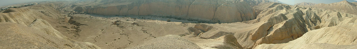
The wadi (seasonal stream) drains the slopes of the Mount of Olives, Mount Scopus and Abu Dis in Jerusalem at 800 m above sea level and descends till the Dead Sea at 400 m below sea level. [3] The steepness of the stream results in heavy flooding during the winter, [1] and in the past, parts of Highway 90 have been swept away. [4] [5] The stream sweeps mud and debris along with the water and sometimes during flooding times it is possible to see a trail of mud, hundreds of meters long, in the waters of the Dead Sea. [6]
On the course of the wadi are the ruins of the Monastery of Theoctistus, known in Arabic as Deir Muqallik. [7] They are hard to access, being situated quite high on the steep northern bank of the wadi at the spot where the valley deepens, turning into a canyon. [7] According to Byzantine sources, it was established in the 5th century by Euthymius and Theoctistus [7] (for more about the monastery see these two articles). Archaeologists confirm that the main phase of the cave church complex and related structures date back to the 5th-7th century, the monastery's 'golden era', with signs of a far less significant habitation period during the Early-Mid Muslim period in the 7th-11th or 12th century. [7] The cave church complex was established at the beginning of the 5th century, and at the end of the 8th the monastery was deserted. [7]
At the foothills of the Judaean Mountains the stream passes by the Muslim shrine of Nabi Musa. [6] In the plain, before reaching the Dead Sea, it also passes next to the kibbutz and Israeli settlement of Almog. [2] Here, towards the end of the stream, a reservoir was built which stores waters from the floods that is used by Almog. [6]
The Dead Sea, also known by other names, is a landlocked salt lake bordered by Jordan to the east, the Israeli-occupied West Bank to the west and Israel to the southwest. It lies in the endorheic basin of the Jordan Rift Valley, and its main tributary is the Jordan River.
The Jordan River or River Jordan, also known as Nahr Al-Sharieat, is a 251-kilometre-long (156 mi) endorheic river in the Levant that flows roughly north to south through the Sea of Galilee and drains to the Dead Sea. The river passes by or through Jordan, Syria, Israel, and the Palestinian territories.
The Judaean Mountains, or Judaean Hills or the Hebron Mountains, are a mountain range in Israel and the West Bank where Jerusalem, Hebron and several other biblical cities are located. The mountains reach a height of 1,026 metres (3,366 ft). The Judean Mountains can be divided into a number of sub-regions, including the Mount Hebron ridge, the Jerusalem ridge and the Judean slopes.
Kidron Valley is the modern name of the valley originating slightly northeast of the Old City of Jerusalem, which then separates the Temple Mount from the Mount of Olives, and ending at the Dead Sea. Beyond Jerusalem it continues in a general south-easterly direction through the Judean desert in the West Bank, reaching the Dead Sea near the settlement of Ovnat, and descending 4,000 feet (1,200 m) along its 20-mile (32 km) course.
The Judaean Desert or Judean Desert is a desert in the West Bank and Israel that lies east of the Judaean Mountains, so east of Jerusalem, and descends to the Dead Sea. Under the name El-Bariyah, it has been nominated to the Tentative List of World Heritage Sites in the State of Palestine, particularly for its monastic ruins.
Euthymius the Great was an abbot in Palestine. He is venerated in both Roman Catholic and Eastern Orthodox Churches.
Wadi Gaza and Besor Stream are parts of a river system in the Gaza Strip and Negev region of Palestine and Israel. Wadi Gaza is a wadi that divides the northern and southern ends of the Gaza Strip, its major tributary is Besor Steam. In 2022 work began to rehabilitate Wadi Gaza Nature Reserve.
Wadi Qelt, in Hebrew Nahal Prat, formerly Naḥal Faran, is a valley, riverine gulch or stream in the West Bank, originating near Jerusalem and running into the Jordan River near Jericho, shortly before it flows into the Dead Sea.
Nahal Taninim or Tanninim or Wadi az-Zarka is a river in Israel near the Arab town Jisr az-Zarqa, originating near Ramot Menashe and emptying into the Mediterranean Sea south of Ma'agan Michael. It marks the southern limit of the Hof HaCarmel, or Carmel Coastal Plain region.
Nahal Amud, also known as the Wadi al-Amud, is a stream in the Upper Galilee region of Israel that flows into the Sea of Galilee.
Nahal Mishmar or Wadi Mahras is a small seasonal stream in the Judean Desert in Israel. A hoard of rare Chalcolithic artifacts, the Nahal Mishmar hoard, was discovered in a cave near the stream bed which was dubbed the "Treasure Cave".
Wadi Khureitun or Nahal Tekoa is a wadi in a deep ravine in the Judaean Desert in the West Bank, west of the Dead Sea, springing near Tekoa.
The Greek Minor Prophets Scroll from Nahal Hever is a Greek manuscript of a revision of the Septuagint dated to the 1st century BC and the 1st century CE. The manuscript is kept in the Rockefeller Museum in Jerusalem. It was first published by Dominique Barthélemy in 1963. The Rahlfs-Siglum is 943.
The Arava Stream is an intermittent stream that flows from the approximate mid-point of the Arava desert in Israel's Southern District northward. It is 89 km long, and in many parts, serves as the actual border between Israel and Jordan. The stream originates on the crest of the Notza Ridge, which forms the watershed divide between the Dead Sea and the Red Sea, and from which all streams in the Arava desert flow either north to the Dead Sea or south to the Red Sea. The stream's prominent tributaries include: Nahal Paran, Nahal Barak, Nahal Tzin, Nahal Tzafit, and Nahal Nekorot. In addition to Israel and Jordan, parts of its drainage basin are in the Sinai Peninsula, Egypt.
Wadi Auja, also spelled Ouja, known in Hebrew as Nahal Yitav is a valley or stream, in the West Bank, originating near the Ein Samia spring and flowing to Al-Auja near Jericho before it runs into the Jordan River.
Cave of Horror is the nickname given to a refuge cave that archaeologists have catalogued as Nahal Hever Cave 8 (8Hev) of the Judaean Desert, Israel, where the remains of Jewish refugees from the Bar Kokhba revolt were found.
The Dishon Stream is an intermittent stream/wadi in Upper Galilee, Israel. It is 26 kilometers long, starts on the eastern slope of Mount Meron and drains into the Jordan River in the area of the drained Hula Lake. It is one of the largest streams in East Upper Galilee. Its name is a modification of the name of the depopulated Palestinian village of Dayshum.
The Harod Stream Hebrew: נחל חרוד, romanized: Nahal Harod, Arabic: نهر جالود, romanized: Wadi Jalud is a stream in Israel that flows west to east, from the Givat HaMoreh area via the Harod Valley and Beit She'an Valley into the Jordan River, about two kilometres (1.2 mi) north of Ma'oz Haim. It is the main drainage route of the Harod Valley
The Bar Kokhba refuge caves are natural caves that were used for shelter by Jewish refugees during the later phases of the Bar Kokhba revolt. Most of the refuge caves were located in the Judaean Desert, nestled within steep cliffs far away from settlements, many overlooking the Dead Sea and the Jordan Valley. Some were also found in ravines flowing into the Dead Sea, while others were nestled within the Judaean Mountains. Unlike the other two hideout systems used by the rebels, the man-made rock-cut hiding complexes, and the hard-to-reach cliff shelters which often contain hewn installations, the refuge caves remained largely untouched by human intervention.