Harissa-Daraoun is a municipality that consists of two villages, Harissa and Daraoun, in the Keserwan District of the Keserwan-Jbeil Governorate of Lebanon. The municipality mayor from 2016 until 2022 is Mr. Nizar Chemaly. The municipality is located 27 km north of Beirut. Its average elevation is 550 meters above sea level and its total land area is 435 hectares. Harissa is accessible from the coastal city of Jounieh either by road or by a nine-minute journey by a gondola lift, known as the Téléphérique. Harissa is home to an important Lebanese pilgrimage site, Our Lady of Lebanon. It attracts both pilgrims and tourists who want to enjoy views of the bay of Jounieh.
Aintoura is a town and municipality in the Keserwan District of the Keserwan-Jbeil Governorate, Lebanon. It is located 18 kilometers north of Beirut. The average elevation of Aintoura is 230 meters above sea level and its total land area is 71 hectares. Its inhabitants are predominantly Maronite Christians.
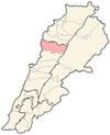
Yanouh is a village and municipality in the Byblos District of the Keserwan-Jbeil Governorate, Lebanon. It is located 94 kilometers north of Beirut. Yanouh's inhabitants are predominantly Maronite Catholics. Its average elevation is 1,120 meters above sea level and its total land area is 147 hectares. Yanouh stands on the slopes of Joubbat El Mnaitra, five miles east of Qartaba, on the right bank high up in the ravine carved out by the Adonis River, now known as Nahr Ibrahim.
Barouk is a village in the Chouf District of Mount Lebanon Governorate in Lebanon. Barouk is located 52 kilometers southeast of Beirut. Its average elevation is 1000 to 1200 meters above sea level and its total land area consists of 2,762 hectares. The village had 5,197 registered voters in 2010. Its inhabitants are predominantly Druze and Maronite and Melkite Christians.
Amsheet is a seaside town and municipality in the Byblos District of Keserwan-Jbeil Governorate, Lebanon, about 40 km north of Beirut. The town's average elevation is 140 meters above sea level and its total land area is 595 hectares. Its inhabitants are predominantly Maronites, although there is a Shia Muslim minority.
Mayfouq is a village and municipality in the Byblos District of Keserwan-Jbeil Governorate, Lebanon. It is located 64 km north of Beirut. Mayfouq has an average elevation of 860 meters above sea level and its total land area is 588 hectares. Its inhabitants are predominantly Maronite Catholics.
Jeita is a town and municipality located in the Keserwan District of the Keserwan-Jbeil Governorate of Lebanon. The town is about 20 kilometres (12 mi) north of Beirut. It has an average elevation of 380 meters above sea level and a total land area of 290 hectares. Jeita's inhabitants are Maronites.
Jaj is a mountainous village in the Byblos District of Keserwan-Jbeil Governorate, Lebanon. It is 68 kilometers north of Beirut. Jaj has an average elevation of 1,220 meters above sea level and a total land area of 1,174 hectares. Its inhabitants are predominantly Maronite Catholics. Jaj is known for its cedar trees high in the mountains. The village is home to many families many of whom come up primarily on weekends.

Ghabat is a village in Lebanon located in the Jurd area of the district of Byblos in the Mount Lebanon region, about 74 kilometres northeast of Beirut. Its inhabitants are predominantly Maronite Catholics.
Zouk Mosbeh is a town and municipality in the Keserwan District of the Keserwan-Jbeil Governorate in Lebanon. It is located 12 kilometers north of Beirut. Zouk Mosbeh's average elevation is 170 meters above sea level and its total land area is 453 hectares. Its inhabitants are predominantly Maronite Catholics and Christians from other denominations. There are three schools in the town, one public and two private, which together enrolled a total of 4,633 students in 2005–2006. There were 167 businesses with over five employees operating in Zouk Mosbeh as of 2006.
Falougha - Khalwat Falougha is a municipality in the Baabda District of Mount Lebanon Governorate, Lebanon. The municipality consists of the villages of Falougha and Khalwat Falougha. It is 35 kilometers east of Beirut. Falougha - Khalwat Falougha has an average elevation of 1,250 meters above sea level and a total land area of 1,563 hectares. In 2016, Falougha had 3,400 registered voters while Khalwat Falougha had 600.

Ghosta is a municipality in the Keserwan District of the Keserwan-Jbeil Governorate of Lebanon. It is located 36 kilometers north of Beirut. Ghosta's average elevation is 950 meters above sea level and its total land area is 461 hectares. Its inhabitants are predominantly Maronite Catholics.

Blat is a municipality in the Byblos District of Keserwan-Jbeil Governorate, Lebanon. It is a suburb of Byblos and is 40 kilometers north of Beirut. Blat has an average elevation of 190 meters above sea level and a total land area of 683 hectares. Its inhabitants are predominantly Maronite Catholics. As of 2008, there were three private schools in the village enrolling 2,560 students, in addition to a campus of the Lebanese American University. There were 28 companies with more than five employees operating in Blat.
Halat is a municipality in the Byblos District of Keserwan-Jbeil Governorate, Lebanon. It is located along the Mediterranean coast, 32 kilometers north of Beirut. Its inhabitants are predominantly Maronite Catholics. Halat has an average elevation of 100 meters above sea level and a total land area of 957 hectares. The town has one public school, which had 112 students in 2008. There were 45 companies with more than five employees operating in Halat as of 2008. There is also a quarry in the town. Charles Bassil is the current municipality president.
Lehfed is a municipality in the Byblos District of Keserwan-Jbeil Governorate, Lebanon. It is 55 kilometers north of Beirut. Lehfed has an average elevation of 1000 meters above sea level and a total land area of 529 hectares. There were three companies with more than five employees operating in the village as of 2008. Its inhabitants are predominantly Maronite Catholics.
Lassa is a municipality in the Byblos District of Keserwan-Jbeil Governorate, Lebanon. It is 90 kilometers north of Beirut. Lassa has an average elevation of 1,130 meters above sea level and a total land area of 739 hectares. The village contains one public school, which enrolled 15 students in 2008. Its inhabitants are predominantly Shia Muslims.

Mghayreh is a municipality in the Byblos District of Keserwan-Jbeil Governorate, Lebanon. It is 82 kilometers north of Beirut. Mghayreh has an average elevation of 1,300 meters above sea level and a total land area of 263 hectares. Its inhabitants are predominantly Maronite Catholics and Shia Muslims.Since the onset of the Syrian Civil War in March 2011, over 1.5 million Syrian refugees have fled to Lebanon, and constitute nearly one-fourth of the Lebanese population today.
Hrajel is a town and municipality located in the Keserwan District of the Keserwan-Jbeil Governorate of Lebanon. The town is about 42 kilometres (26 mi) north of Beirut. It has an average elevation of 1,320 meters above sea level and a total land area of 1,230 hectares. Hrajel's inhabitants are Maronites.
Jouret el-Termos is a village and municipality located in the Keserwan District of the Keserwan-Jbeil Governorate in Lebanon. The village is 37 kilometres (23 mi) north of Beirut. It has an average elevation of 1,010 meters above sea level and a total land area of 122 hectares. Jouret el-Termos's inhabitants are Maronites.
Okaibe is a coastal village in Keserwan-Jbeil Governorate in Lebanon, well known for its public sandy beach, fishing port and market. It is a mix of a semi urban lively market street, and three distinctive residential areas situated on elevated ground and overlooking the coast. The river of "Nahr Ibrahim" runs through Okaibe and flows into the sea along the famous sandy beach. Historically a fishing community, with exclusively local residents, Okaibe has recently opened up through small scale real-estate investments that boosted the population growth, not to mention the inflow of immigrants following the Syrian civil war.