
Sokna is a small village located between Hønefoss and Krøderen in the municipality of Ringerike, in the county of Buskerud, Norway. Its population is 543.

Buskerud is a traditional region, a former county and a current electoral district in Norway, bordering Akershus, Oslo, Oppland, Sogn og Fjordane, Hordaland, Telemark and Vestfold. The region extends from the Oslofjord and Drammensfjorden in the southeast to Hardangervidda mountain range in the northwest. The county administration was in modern times located in Drammen. Buskerud was merged with Akershus and Østfold into the newly created Viken County on 1 January 2020.

Marka is the name of the forested and hilly areas surrounding Oslo, Norway. It includes areas within the municipality of Oslo, but also large areas in Hole, Ringerike, Jevnaker, Lunner, Nittedal, Bærum, Asker, and other municipalities in Viken county. The name is actually just the finite form of mark 'woodland, forest'.

Hønefoss is a town and the administrative center of the municipality of Ringerike in Buskerud county, Norway. Hønefoss is an industrial center of inner Østlandet, containing several factories and other industry. As of 1 January 2008, Hønefoss has 14,177 inhabitants. In 1852, Hønefoss received town status and was separated from Norderhov. In 1964, Hønefoss ceased being a separate municipality and became part of Ringerike.

Nordmarka is the mostly forested region which makes up the northern part of Oslo, Norway. Nordmarka is the largest and most central part of Oslomarka. The area called Nordmarka also extends into the municipalities of Hole, Ringerike, Lunner, Jevnaker and Nittedal. It is the largest part of the Marka borough.

Veggli is a village in the municipality of Rollag, in the county of Buskerud, Norway.

Kroksund is a small village in the municipality of Hole, in Buskerud, Norway.

Sundvollen is a village in the municipality of Hole, in the county of Buskerud, Norway. Sundvollen is located along the east side of Tyrifjorden where the E16 crosses west over Steinsfjorden, the northeastern arm of Tyrifjorden, to Kroksund. The village had 801 inhabitants as of January 2009.

Tyristrand is a village in Ringerike municipality in Buskerud county, Norway.
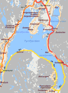
Steinsåsen is a village in Hole municipality in Buskerud, Norway. Steinsåsen located on the west side of Steinsfjorden, the eastern arm of Tyrifjorden. The village is about 9 km southeast of Honefoss. European route E16 passes through Steinsåsen as it travels from Oslo to Bergen.

Hen is a small village in the municipality of Ringerike in Buskerud, Norway.

Norderhov is a former municipality located within Ringerike in Buskerud county, Norway.

Haugsbygd is a village in Ringerike municipality, northeast of the center of Hønefoss, in Buskerud, Norway.

Ulefoss is the administrative centre of Nome municipality in Telemark, Norway, located near the border of Grenland. Its population is 2,699. It occupies both sides of Ulefoss falls on the river Eidselva. Ulefoss is one of Norway's oldest industrial communities, with sawmills operating from the 1400s, and mining and ironworks from the 1600s. It is still largely an industrial site, with a number of people employed in the iron foundry and mechanical industries. Ulefoss has primary school, lower secondary, and upper secondary school Søve. A variety of shops and restaurants, a library and culture centre are also located here. Øvre Verket is a group of old workers' dwellings; today a culture and crafts exhibition.

Åsbygda is a small village in Ringerike municipality of Buskerud, Norway.

Visnes is a village in Karmøy municipality in Rogaland county, Norway. The village is located on the western shore of the island of Karmøy, about 2.5 kilometres (1.6 mi) west of the village of Avaldsnes. The 0.57-square-kilometre (140-acre) village has a population (2014) of 569, giving the village a population density of 998 inhabitants per square kilometre (2,580/sq mi).

Sulitjelma (Norwegian), Sulisjielmmá (Lule Sami), or Sulitelma (Swedish) is a village in the municipality of Fauske in Nordland county, Norway. Sulitjelma is situated in a lush inland valley at an elevation of 140 metres (460 ft) above sea level. It is located on the shore of Langvatnet lake, about 35 kilometres (22 mi) southeast of the town of Fauske. The lakes Låmivatnet, Kjelvatnet, and Muorkkejávrre are located to the east and south of the village.
Ask is a village in Ringerike municipality, Buskerud, Norway. Ash is located along Norwegian national road Rv35 approx. 6 km southwest of the municipality Hønefoss. The village once had a railway station on the Randsfjord Line. Ask is most known for Ask Chapel and for Ask gods, a Manor house owned by the Løvenskiold family.

Krokskogen is a forested area which located outside of Oslo, Norway. It is a part of Oslomarka and is situated between Bærumsmarka, Vestmarka and Nordmarka.
Gullverket is a village in Eidsvoll municipality, Akershus county, Norway. The village is situated just east of Minnesund, near the border with Hedmark.
