Related Research Articles

Palakkad District is one of the 14 districts in the Indian state of Kerala. It was carved out from the southeastern region of the former Malabar District on 1 January 1957. It is located at the centre of Kerala. It is the largest district in the state since 2006. The city of Palakkad is the district headquarters. Palakkad is bordered on the northwest by the Malappuram district, on the southwest by the Thrissur district, on the northeast by Nilgiris district, and on the east by Coimbatore district of Tamil Nadu. The district is nicknamed "The granary of Kerala". Palakkad is the gateway to Kerala due to the presence of the Palakkad Gap, in the Western Ghats. The 2,383 m high Anginda peak, which is situated in the border of Palakkad district, Nilgiris district, and Malappuram district, in Silent Valley National Park, is the highest point of elevation in Palakkad district. Palakkad city is located just 50 km away from Coimbatore, a major city in Tamil Nadu state.

Nelliyampathy is a hill station, located 60 kilometres (37 mi) from Palakkad, state of Kerala, India.
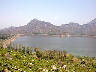
Pothundi Dam is an irrigation dam near Pothundi village in the Palakkad district of Kerala state, India. Constructed in the 19th century, it is considered one of the oldest dams in India. It provides irrigation to an area of 5,470 hectares in the Palakkad district and drinking water supply to the Nemmara, Ayalur, Melarcode Panchayat. An unusual feature of the earth dam is the core wall, which is built with a mixture of jaggery and quick lime.
Alathur is a town, taluk and gram panchayat in Palakkad District, Kerala, India. It is the administrative headquarters of the Alathur Taluk and is situated about 24 km from the district headquarters Palakkad through National Highway 544.Gayathripuzha River ,one of the tributary of Bharathapuzha,flows through Alathur. Alathur is one among the 29 Parliamentary Constituencies in Kerala.It is also famous for its tasty chips made from SNR chips,a bakery located in the town itself.A Mini Civil Station is also located here which provides government related services.

Pattambi is a town taluk and municipality in the Palakkad district of the state of Kerala, India. It is also the administrative headquarters of the Pattambi Taluk. Pattambi is located along the banks of Bharathappuzha river. A Mini Civil Station also functions here to provide government related services.

Chittur-Thathamangalam is a town and municipality in Palakkad district of Kerala State, India. It is the headquarters of Chittur taluk, 13 km (8.1 mi) south-east of Palakkad, on the banks of the Kannadipuzha, a major headstream of the Bharathapuzha, the second longest river in Kerala. It was once part of the former Kingdom of Cochin. The municipality consists of Chittur, Thathamangalam, Pallimokku, Kannanthara, Puzhampalam, Kacherimedu, Anicode, Thekkegramam and Kadambidi.

Pallavur is a village situated in the Chittur Taluk, Palakkad district of Kerala, India. It is close to Kollengode Town, Nemmara and Koduvayur.
Peruvemba is a village and gram panchayat near Chittur-Thathamangalam in the Palakkad district of Kerala, India. Within the village is the Ootukulangara Bhagavathy Temple.
Ayiloor, also known as Ayilur, Aylur, or Ayalur, is a village in the Chittur Thaluk of Palakkad district, state of Kerala, India. Ayiloor is located about 30 kilometers away from Palakkad town and 48 kilometers from Thrissur town.
Chittur is a village in Palakkad district in the state of Kerala, India. A part of it is governed by the Nalleppilly gram panchayat, along with the villages of Nalleppilly and Thekkedesom.
Eruthempathy is a village in the Palakkad district, state of Kerala, India. It forms a part of the Eruthampathy gram panchayat.
Nallepilly is a village in the Palakkad district, state of Kerala, India. It is the main village of the Nalleppilly gram panchayat and forms a part of Chittur taluk.
Pattancherry is a village in the Palakkad district, state of Kerala, India. It forms a part of the Pattencherry gram panchayat.
Polpully is a village and gram panchayat in Palakkad district in the state of Kerala, India. The village is located 10 km from Palakkad city, and 5 km from Chittur.
Thekkedesom is a village in the Palakad district, state of Kerala, India. It forms a part of the Nalleppilly gram panchayat, which is itself subordinate to the Chittur taluk.
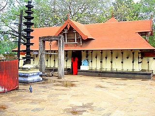
Pallassena or Pallassana is a village and gram panchayat in the Palakkad District, state of Kerala, India. It is close to Kollengode Town and Koduvayur and beside the river Gayatri, one of the tributaries of Bharatapuza. It is primarily notable for being the location of the Meenkulathi Temple.
Athicode is an old junction village in Palakkad district of Kerala state, India. It is the main junction to the towns of Palakkad (20 km), Pollachi (25 km), Coimbatore (35 km) and Chittur (16 km). Half of the village is in Kozhinjampara panchayat and other half in Nallepilly panchayat.
Edappadi is a taluk of Salem district in the Indian state of Tamil Nadu. The administrative centre is the town of Edappadi. The taluk contains two panchayat towns, Konganapuram and Poolampatti, and ten panchayat villages. The Edappadi revenue block is coterminous with the taluk.
Chinna Nagapoondi is a panchayat village located in Tiruvallur district of Tamil Nadu, India. It is located on the Sholinghur–Chittur highway and falls under the R. K. Pettai circle. The village is home to about 500 agricultural family. Per 2001 census, the population of the village was 944.

Pattambi is a taluk at the western end of the Palakkad district of the state of Kerala, India. Town of Pattambi is the administrative headquarters of the taluk. Pattambi taluk is bounded by Ottapalam Taluk of Palakkad district to the east, Ponnani taluk of Malappuram district to the west, Tirur and Perinthalmanna Taluks of Malappuram district to the north, and Kunnamkulam Taluk of Thrissur district to the south.
References
- ↑ "Reports of National Panchayat Directory". Ministry of Panchayati Raj. Archived from the original on 30 December 2013. Retrieved 29 December 2013.
| | This article related to a location in Palakkad district, Kerala, India is a stub. You can help Wikipedia by expanding it. |