
Zambia, officially the Republic of Zambia, is a landlocked country at the crossroads of Central, Southern and East Africa. It is typically referred to being in South-Central Africa or Southern Africa. It is bordered to the north by the Democratic Republic of the Congo, Tanzania to the north-east, Malawi to the east, Mozambique to the southeast, Zimbabwe and Botswana to the south, Namibia to the southwest, and Angola to the west. The capital city of Zambia is Lusaka, located in the south-central part of Zambia. The population is concentrated mainly around Lusaka in the south and the Copperbelt Province to the north, the core economic hubs of the country.
Solwezi is a town in Zambia. It is the provincial capital of the mineral-rich North-Western Province. Solwezi is also the administrative capital of Solwezi District, one of the eleven districts in the North-Western Province.
Kasama is a town in the Northern Province of Zambia. It serves as the provincial capital and the headquarters of Kasama District.
Mumbwa is a town in the Central Province of Zambia, lying on the M9 Road. Its district covers the western part of the Central Province bordering Kaoma and Western Province to the west, Namwala and Southern Province to the south, Lusaka and Lusaka Province to the east, Kasempa and North-Western Province to the north and Kabwe to the north-east. It is known for its cotton and has a ginnery. The Zambia Air Force has a base in the district. Kafue National Park borders the district to the west. The predominant tribes are the Ila, who speak a dialect known as Sala, mostly to the south and south east and the Kaonde to the north. The Lenje are to the north-east on the border area with Kabwe. There are also relatively large settlement of people from the west and north west such as the Lozi, Nkoya and Luvale, Shona people from the then Southern Rhodesia who settled there as refugees from the civil war in that country and who are now almost integrated and Tonga from the south. A lot of prospecting for minerals such as copper and gold was done in the district and small scale mines operated there. Most are now closed, though the gold mine at Luiri has been revived.

Central Province is one of Zambia's ten provinces. The provincial capital is Kabwe, which is the home of the Mulungushi Rock of Authority. Central Province has an area of 94,394 km (58,654 mi). It borders eight other provinces and has eleven districts. The total area of forest in the province is 9,095,566 ha, and it has a national park and three game management areas. The first mine in the region was opened up in 1905 making the then Broken Hill town the first mining town. In 1966, the town's name was reverted to its indigenous name - Kabwe meaning 'ore' or 'smelting'.

Southern Province is one of Zambia's ten provinces. It is home to Zambia's premier tourist attraction, Mosi-oa-Tunya, shared with Zimbabwe. The centre of the province, the Southern Plateau, has the largest area of commercial farmland of any Zambian province, and produces most of the maize crop.

The ten provinces of Zambia are divided into a total of 116 districts as of 2018.
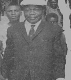
Harry Mwaanga Nkumbula was a Zambian nationalist leader involved in the movement for the independence of Northern Rhodesia, as Zambia was known until the end of British rule in 1964. He was born in the village of Maala in the Namwala district of Zambia's southern province. He was the youngest of three children and the only son.
The Kafue Flats are a vast area of swamp, open lagoon and seasonally inundated flood-plain on the Kafue River in the Southern, Central and Lusaka provinces of Zambia. They are a shallow flood plain 240 km (150 mi) long and about 50 km (31 mi) wide, flooded to a depth of less than a meter in the rainy season, and drying out to a clayey black soil in the dry season.
Ngoma Airport is a rural airstrip serving Ngoma, a settlement within the Kafue National Park in the Southern Province in Zambia.

The T1 or Lusaka–Livingstone Road is the main highway of the Southern Province of Zambia. It begins 55 kilometres south of the city of Lusaka and heads south-west to the principal tourist destination, Victoria Falls in Livingstone, via Mazabuka, Monze, Choma and Kalomo, measuring approximately 430 kilometres (267 mi). The entire route is part of Trans-African Highway network number 4 or Cairo-Cape Town Highway between Cairo and Cape Town.
Itezhi-Tezhi is a small town in the Southern Province of Zambia. It is the seat of the Itezhi-Tezhi District. It lies west of the town of Namwala on the border of the Kafue National Park.
Shimunenga is a ceremony of the Ba-Ila people of Maala in Namwala District, Zambia. It is celebrated on the weekend of the full moon in September or October. It is named after the legendary warrior Shimunenga, who won a battle for the people's territory against his brother.

Chama District with the headquarters at Chama is the largest district of the Eastern Province in Zambia and includes a large wilderness in the Upper Luangwa valley just north-east of the North Luangwa National Park. It is made up of two constituencies, namely Chama North and Chama South.

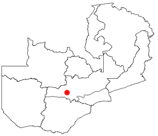
Namwala District is a district of Zambia, located in Southern Province. The capital lies at Namwala. As of the 2022 Zambian Census, the district had a population of 167,938 people.

Chipata District is a district of Zambia, located in Eastern Province. The capital lies at Chipata. As of the 2022 Zambian Census, the district had a population of 327,059 people.
The Ila people are an ethnic group in The Republic of Zambia who make up 0.8 percent of the total population.

Chirundu District is a district of Southern Province, Zambia. Its headquarters is Chirundu. It was separated from Siavonga District by President Michael Sata in 2012. As of the 2022 Zambian Census, the district had a population of 78,780 people.
The M11 road is a road in the Southern Province of Zambia that connects Choma with Namwala. It is the main road connecting Namwala to the rest of the Southern Province. It is approximately 169 kilometres in length.
Namwala is a constituency of the National Assembly of Zambia. It covers Namwala and surrounding areas in Namwala District of Southern Province.
