
Chittorgarhpronunciation (help·info) is a major city in Rajasthan state of western India. It lies on the Berach River, a tributary of the Banas, and is the administrative headquarters of Chittorgarh District. It was capital of Rajput State of Medapata during 8th to 16th Century. The city of Chittorgarh is located on the banks of river Gambhiri and Berach.

Pindwara is a municipality and tehsil located in Sirohi District in the Indian state of Rajasthan. Pindwara is one of main financial city of Sirohi district after Abu Road. As of 2011, the population of Pindwara is 24,487. It is located 435 km (270 mi) southwest of the state capital, Jaipur, between Aravalli Hills and plains of Marwar region. The city used to be a major area of marble and stone carving in India by long time. It is common belief that if there is any construction of temple work all over the world, it could not complete without involvement of Pindwara artisan. This is proved by this fact that marble carvings of major temples of India like Akshardham temple network, Shri Ram temple Ayodhya are being carried out in the city.
Pali is a city in Rajasthan state of India. It is the administrative headquarters of Pali District and comes in the Marwar region. It is situated on the bank of the river Bandi and is 70 km south east of Jodhpur. It is known as "The Industrial City".
Patan is a town in the Indian state of Rajasthan. In the 12th century, it became the centre of a minor state called Tanwarawati or Torawati, ruled by a Tomar family. Anangpall II, who established the city of Patan and ruled present day Delhi. Anangpall II, is considered to be a direct descendant of Raja Parikshit, Son of Abhimanyu and Grandson of Arjuna. (Pandavas)
Gogunda is a town and tehsil headquarters of Gogunda tehsil in Udaipur district, located about 35 km in north-west from Udaipur city in the Indian state of Rajasthan. It is situated on a high mountain in Aravalli hills and is reached by crossing a difficult mountain pass.

Pali District is a district of the state of Rajasthan in western India.The town of Pali is the district headquarters.
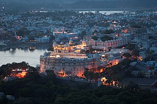
Udaipur also known as the "City of Lakes", is a city in the state of Rajasthan, India. It is the historic capital of the kingdom of Mewar in the former Rajputana Agency. It was founded in 1558 by Udai Singh II of the Sisodia clan of Rajput, when he shifted his capital from the city of Chittorgarh to Udaipur after Chittorgarh was besieged by Akbar. It remained as the capital city till 1818 when it became a British princely state, and thereafter the Mewar province became a part of Rajasthan when India gained independence in 1947.
Sanderao is a village in Pali district of Rajasthan state in India. It lies 16 km north west of Bali town. It was founded by Yasobhadra in the tenth century. This place was governed by Sisodia rulers of Udaipur. Today Sanderao is an important junction of many road routes of the area. The nearest railway station is Falna. Sanderao is located at important junction linking four major roads. The main important economic activity is agriculture and animal husbandry. This place is also famous for its migrant community which is spread all over country and abroad and done very well in business and trades. Sanderao Jain Teerth here is around 2,500 years old. There is a holy 5000 years old pilgrimage " Nimbeshvara Mahadeva ".
Deogarh, also known as Devgarh, is a city and a municipality in Rajsamand District in the Indian state of Rajasthan. Formerly the city was an estate of the Chundawat Rajputs.
Kanore is a town in Udaipur district in the Indian state of Rajasthan.

Bali is a town founded by balecha chouhan king bala chouhan and it is an heart of gorwar. town is a municipality in Pali district in the state of Rajasthan, India. The town is situated on the left bank of the Mithari River. This walled town was the headquarters of a district having the same name in the Jodhpur State. Bali is a tehsil and panchayat samiti with the same name. Bali is also a sub-divisions among the 10 sub-divisions of the Pali district. It is known for its fort. Nearest towns are Falna & Sadri and nearest villages are Shri sela & boya. A dispensary was established in this town in March 1896. It had beds for six in-patients. In 1897, it served 17 in-patients and 4166 out-patients and 318 operations were performed in it. In 1900 there was a plague outbreak in town and the town was evacuated. 1245 deaths occurred during the month of January 1900 as a result of diarrhoea, dysentery and pneumonia. The population of Bali in 1901 was 5186. It had a vernacular school, and post office. Prior to formation of Rajasthan it was headquarters of a district with same name in erstwhile Jodhpur state. Bali had its own municipality even before independence. It had a middle school in 1932 that was upgraded to high school and in 1946 had more than 200 pupils. In 1960 Bali had three primary schools for boys, one primary school for girls and a high school. The telephone arrived in Bali in 1957, it got electricity in 1961 and piped water connections were given in 1970. A tehsil library was established in the center of Bali in Bawari Jav in 1958. In addition Bali also has a Jain library. In bali village one of famous seervi aai mata Hindu temple many seervi farmers living in bali
Bapna also spelt Bafana or Bapna or Bafna is an Indian Jain community, and also the surname used by this community. The name is derived from Bahufana and Bafanha. They were Rajput and embraced Jainism.In some areas of Rajasthan like Udaipur and Jaipur there are also Bapna of Brahmin Caste and are known as Bapna Brahmins. Bafnas are also known as Bapnas, Baphana.
Rikhabdeo is a census town in Udaipur district in the state of Rajasthan, in north-west India.

Mandela was established in 1751 by Raj-Shri Thakur Sahab Doulat Singh Ji, third son of Maharao Zorawar Singh ji of Jhunjhunu, and grandson of Maharao Shardul singh ji Jhunjhunu. Mandela is a town in the Shekhawati Region Jhunjhunu district of the state Rajasthan in India. The population size is about 30,000.

Ganj Basoda, called Basoda, city and municipality in the Indian state of Madhya Pradesh. Ganj Basoda is one of the eleven tehsils of Vidisha district ganj Basoda 39 km from Vidisha.

Lok-Priya Sant-Kavi Maharaj Chatur Singhji लोक-प्रिय सन्त-कवि महाराज चतुर सिंहजी reverently known as Bavji Chatur Singhji, was born on Monday 9 February 1880 at Karjali Haveli to Rani Krishna Kunwar and Maharaj Surat Singh of Karjali. Bavji Chatur Singhji was a popular people’s saint-poet of Rajputana, now Rajasthan, India, who was an accomplished yogi also and is rightly remembered as Patanjali and Valmiki of Rajasthan.
Ambamata Temple, a large Hindu temple in the middle of Udaipur in Rajasthan, is considered as one of the major places of worship in Udaipur. This temple was constructed by Maharana Raj Singh of Udaipur. It is assumed that he built this temple on the instructions of the goddess Amba Mata in Gujarat.

Udaipur, India was founded in 1553, by Maharana Udai Singh II in the fertile circular Girwa Valley to the southwest of Nagda, on the Banas River. The city was established as the new capital of the Mewar kingdom.

Pratap Gaurav Kendra Rashtriya Tirtha is a tourist spot at Tiger Hill in Udaipur city, Rajasthan state, India. The project, which was started by the Veer Shromani Maharana Pratap Samiti, aims at providing information about Maharana Pratap and the historical heritage of the area with the help of modern technology.

