
Ranakpur is a village located in Desuri tehsil near Pali city in the Pali district of Rajasthan in western India. It is located between Jodhpur and Udaipur, 162 km from Jodhpur and 91 km from Udaipur, in a valley on the western side of the Aravalli Range. The nearest railway station to reach Ranakpur is Falna and Rani railway station. Ranakpur is easily accessed by road from Udaipur, Pali district in Rajasthan. Ranakpur is one of the most famous places to visit in Pali, Rajasthan and is widely known for its marble Jain temple, said to be the most spectacular of the Jain temples.
Beawar is a city in Ajmer district of Rajasthan, India. Beawar was the financial capital of Merwara state of Rajputana. As of 2011, the population of Beawar is 342,935. It is located 70 kilometres from Ajmer, the district headquarters and 184 kilometres (114 mi) southwest of the state capital Jaipur, amidst Aravali hills. The city used to be a major center for trade, especially in raw cotton, and used to have cotton presses and the Krishna cotton mills. Currently, major industries include mineral-based units, machine-based units, machine tools and accessories, pre-stressed concrete pipes, plastic products, textiles, wooden furniture and asbestos cement pipes. Beawar is the largest producer of cement in northern India and home to Shree Cement. It is situated in a mineral-rich region having reserves of feldspar, quartz, asbestos, soapstone, magnesite, calcite, limestone, mica, emerald, granite, and masonry stone. Reserves of barytes, fluorite, wollastonite and vermiculite have also been found. Nearest airports are Jodhpur (145 km), Kishangarh and Jaipur (190 km). It is also connected by RSRTC operated buses to all parts of Rajasthan, and neighboring Delhi NCR, Ahmedabad (Gujarat), Gwalior. It also has railway connectivity with Delhi, Mumbai, Ahmadabad, Bangalore (bi-weekly), Haridwar, Dehradun (weekly), Bareilly and Muzzafarpur.

Pali district is a district in Rajasthan, India. The city of Pali is its administrative headquarters. Pali is also known as the Industrial/Textile City and has been a hub for merchant activities for centuries. It has a rich heritage and culture, including beautiful Jain temples and other elaborate monuments.

Takhatgarh is a town in Pali District of Rajasthan state in India. The town is one of the nine municipalities in the district, located near the district border. It is only about 160 years old. This town is Up-tensile headquarter also since 2023.
Bareli is a town and a Municipality in Raisen district in the state of Madhya Pradesh, India. It is located in the Bareli tehsil. Bareli is a town in the Raisen district. There is a sub-jail in Bareli. Bareli is located on bank of Barna River. Bareli has National Krishi Upaj Mandi and it produces Wheat, Soyabean, Rice and different vegetable in different seasons. Bareli is connected with National Highway that connects to Bhopal and Jabalpur via NH-12(or NH-45)

Kanore is a town in Udaipur district in the Indian state of Rajasthan.

Mundi is a city and tehsil in the Khandwa district of Nimar region in the Indian state of Madhya Pradesh. It is situated in North Side of East Nimar District.
Pachore is a Tahsil Place and a nagar panchayat in Rajgarh district of Madhya Pradesh in India. It is situated on Agra-Bombay Road - NH 52 at the bank of the river Nevaj. Pachore Mandi is the biggest Mandi of Rajgarh District.

Sadri is a municipality in the Pali district of Rajasthan, India. It is considered the gateway to Marwar from Mewar. Sadri is one of the main places of worship for the Jain community. Ranakpur Temple and Shri Parshuram Mahadev Mandir are located in Sadri, which became a municipality in 1961. Bhadras is located 3 km from Sadri along the Suhai river.

Bali is a town and a municipality in Pali district in the state of Rajasthan, India. The town is situated on the left bank of the Mithari River. This walled town was the headquarters of a district having the same name in the Jodhpur State. Bali is a tehsil and panchayat samiti with the same name. Bali is also a sub-divisions among the 10 sub-divisions of the Pali district. It is known for its fort. Nearest towns are Falna & Sadri and nearest villages are Kot Baliyan, Shri Sela and Boya.
Bamnera is a small village situated along the inner margin of the southwestern part of the Thar Desert in the foothills of Aravali mountain range with panoramic landscapes and a few sandy tracks. In more urban geographical terms, it is situated in the Sumerpur tehsil of Pali District in the state of Rajasthan, 12.5 km west of Sheoganj-Sirohi District from Beawar-Radhanpur NH 14.
Koliwara is a small town located in Sumerpur Tehsil in Pali district, Rajasthan, India. It lies 4 km. from Sumerpur, 3 km. from Bhagawan Mahavir Hospital on Jawai Bandh road. Nearest railway station is Jawai Bandh. There are 4 schools, one hospital, one veterinary hospital, one post office, and Gram Panchayat. It is also famous for wood carving and artwork. Bus service is available to village on hourly basis. The village is also connected to Jakhora by road.
Sai-Dham at Rani, (Rajasthan) is a replica of original Shirdi Sai Baba Temple.
Khimel is an Indian village situated between Rani and Falna rail station in the Pali District of Rajasthan state. Khimel is divided into two parts: the village and dhani. Khimel is a village in Bali Tehsil in Pali District of Rajasthan, India. It belongs to Jodhpur Division. It is located 60 km towards South from District headquarters Pali. 22 km from Bali. 362 km from State capital Jaipur Khimel Pin code is 306115 and postal head office is Rani Sadar Bazar. Khimel have a small railway station where only local trains halts. Khimel receives 24/7 electricity. This region is called Gorwar and popular language is Marwari. Falna, Bali, Sadri, Sumerpur are the nearby Cities to Khimel.
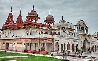
Shri Mahavir Ji is an important and prominent Jain pilgrimage site situated in Shri Mahaveerji town in Hindaun Block, Karauli district in Rajasthan. Given the importance of the religious place, the Indian Railways has specifically developed a railway station under West Central Railway zone by the name of Shri Mahaveerji railway station which is 10 minutes drive from the temple and temple authorities have arranged for regular buses from the station to the temple. The temple is visited by millions of Jain and Hindu devotees every year.
Ranawas is a village located in Kharci Tehsil of Pali district in Rajasthan state of India. It is also a railway station on Marwar Junction to Udaipur route.
Guda Endla is a village located in Pali District of Rajasthan in Western India. It has a population of about 10,000. Demographically, Guda Endla village is dominated by Meenas, Meghwal, Chaudhary and Jain communities.
Bagol is a village in the Desuri tehsil in the Pali district of Rajasthan, India. It was established by Keshu Das and Bheek Singh. It is near Sadri on state highway SH 62 between Ganthi and Magartalav-Kolar, in a valley on the western side of the Aravalli Range. Bagol is accessible by road from Jojawar and Khinwara to Desuri.
Peepal Khoont mainly known as Pipalkhunt is a village, Tehsil headquarter and Panchayat Samiti of the Pratapgarh district of Rajasthan state. It is a sub-division among the 5 sub-divisions of the Pratapgarh district. The main market is called Sadar Bajar. It is situated on National Highway 113. Pipalkhunt is a town located on the Banswara - Jaipur Expressway surrounded by the hills, plants and trees. The town is situated on the bank of the Mahi River.
Fateh Singhpura is a railway station on the West Central railway network at Suroth, Suroth Tehsil in India. It comes under the Kota railway division of West Central Railway zone Fatehsinghpura is a D-Grade station on the Delhi–Mumbai route.

