Related Research Articles

An earthquake – also called a quake, tremor, or temblor – is the shaking of the Earth's surface resulting from a sudden release of energy in the lithosphere that creates seismic waves. Earthquakes can range in intensity, from those so weak they cannot be felt, to those violent enough to propel objects and people into the air, damage critical infrastructure, and wreak destruction across entire cities. The seismic activity of an area is the frequency, type, and size of earthquakes experienced over a particular time. The seismicity at a particular location in the Earth is the average rate of seismic energy release per unit volume.

The 1811–1812 New Madrid earthquakes were a series of intense intraplate earthquakes beginning with an initial earthquake of moment magnitude 7.2–8.2 on December 16, 1811, followed by a moment magnitude 7.4 aftershock on the same day. Two additional earthquakes of similar magnitude followed in January and February 1812. They remain the most powerful earthquakes to hit the contiguous United States east of the Rocky Mountains in recorded history. The earthquakes, as well as the seismic zone of their occurrence, were named for the Mississippi River town of New Madrid, then part of the Louisiana Territory and now within the U.S. state of Missouri.

In seismology, an earthquake swarm is a sequence of seismic events occurring in a local area within a relatively short period. The time span used to define a swarm varies, but may be days, months, or years. Such an energy release is different from the situation when a major earthquake is followed by a series of aftershocks: in earthquake swarms, no single earthquake in the sequence is obviously the main shock. In particular, a cluster of aftershocks occurring after a mainshock is not a swarm.
The 1993 Latur earthquake struck India at 3:56 am local time (UTC+05:30) on 30 September. The main area affected is the districts of Latur and Osmanabad, including the Ausa block of Latur and Omerga of Osmanabad in Maharashtra, Western India. Fifty-two villages were demolished in the intraplate earthquake. It measured 6.2 on the moment magnitude scale, and approximately 10,000 people died, whilst another 30,000 were injured. The earthquake's hypocenter was around 10 km deep – relatively shallow – allowing shock waves to cause more damage. It is considered the deadliest earthquake in the stable continental crust to have occurred in recorded history.

Latur district is a district in Maharashtra state of India. Latur city is the district headquarters and is the 16th largest city in the state of Maharashtra. The district is primarily agricultural. Urban population comprises 25.47% of the total population.

The Indian subcontinent has a history of devastating earthquakes. The major reason for the high frequency and intensity of the earthquakes is that the Indian plate is driving into Asia at a rate of approximately 47 mm/year. Geographical statistics of India show that almost 58% of the land is vulnerable to earthquakes. A World Bank and United Nations report shows estimates that around 200 million city dwellers in India will be exposed to storms and earthquakes by 2050. The latest version of seismic zoning map of India given in the earthquake resistant design code of India [IS 1893 2002] assigns four levels of seismicity for India in terms of zone factors. In other words, the earthquake zoning map of India divides India into 4 seismic zones unlike its previous version, which consisted of five or six zones for the country. According to the present zoning map, Zone 5 expects the highest level of seismicity whereas Zone 2 is associated with the lowest level of seismicity.
The 1975 Morris earthquake occurred in western Minnesota on July 9 at 14:54:15 UTC, or 9:54 a.m. local time. The strongest instrumentally recorded rupture in the history of the state, it registered at magnitude 4.6 Mn and had a maximum Mercalli intensity of VI (Strong). It was the first earthquake to be recorded on any seismic instrument in the state since 1917. Tremors were felt over much of Minnesota, northern Iowa, and the eastern Dakotas.
The Near East earthquakes of 1759 were a series of devastating earthquakes that shook a large portion of the Levant in October and November of that year. This geographical crossroads in the Eastern Mediterranean were at the time under the rule of the Ottoman Empire. The ruins of Baalbek, a settlement in the Beqaa Valley of Lebanon east of the Litani River, were badly damaged. These 1759 events, along with the earlier 1202 Syria earthquake, are likely the strongest historical earthquakes in the region.

The 1968 Illinois earthquake was the largest recorded earthquake in the U.S. Midwestern state of Illinois. Striking at 11:02 am on November 9, it measured 5.4 on the Richter scale. Although no fatalities occurred, the event caused considerable structural damage to buildings, including the toppling of chimneys and shaking in Chicago, the region's largest city. The earthquake was one of the most widely felt in U.S. history, largely affecting 23 states over an area of 580,000 sq mi (1,500,000 km2). In studying its cause, scientists discovered the Cottage Grove Fault in the Southern Illinois Basin.
A series of small volcanic earthquakes measuring less than 4.0 on the Richter magnitude scale took place in the sparsely populated Nazko area of the Central Interior of British Columbia, Canada, from October 9, 2007, to June 12, 2008. They occurred just west of Nazko Cone, a small tree-covered cinder cone that last erupted about 7,200 years ago.
The 1867 Manhattan earthquake struck Riley County, Kansas, in the United States on April 24, 1867, at 20:22 UTC, or about 14:30 local time. The strongest earthquake to originate in the state, it measured 5.1 on a seismic scale that is based on an isoseismal map or the event's felt area. The earthquake's epicenter was near the town of Manhattan.
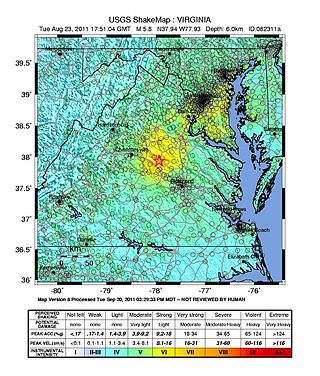
On August 23, 2011, a magnitude 5.8 earthquake hit the Piedmont region of the U.S. state of Virginia at 1:51:04 p.m. EDT. The epicenter, in Louisa County, was 38 mi (61 km) northwest of Richmond and 5 mi (8 km) south-southwest of the town of Mineral. It was an intraplate earthquake with a maximum perceived intensity of VIII (Severe) on the Mercalli intensity scale. Several aftershocks, ranging up to 4.5 Mw in magnitude, occurred after the main tremor.

The 2011 Oklahoma earthquake was a 5.7 magnitude intraplate earthquake which occurred near Prague, Oklahoma on November 5 at 10:53 p.m. CDT in the U.S. state of Oklahoma. The epicenter of the earthquake was in the vicinity of several active wastewater injection wells. According to the United States Geological Survey (USGS), it was the most powerful earthquake ever recorded in Oklahoma until the 2016 Oklahoma earthquake. The previous record was a 5.5 magnitude earthquake that struck near the town of El Reno in 1952. The quake's epicenter was approximately 44 miles (71 km) east-northeast of Oklahoma City, near the town of Sparks and was felt in the neighboring states of Texas, Arkansas, Kansas and Missouri and even as far away as Tennessee and Wisconsin. The quake followed several minor quakes earlier in the day, including a 4.7 magnitude foreshock. The quake had a maximum perceived intensity of VIII (Severe) on the Mercalli intensity scale in the area closest to the epicenter. Numerous aftershocks were detected after the main quake, with a few registering at 4.0 magnitude.
The 1964 Rosais earthquake was a series of seismic swarms occurring in February 1964, leading to two major earthquakes on 15 and 21 February, resulting in the destruction of most of the habitable dwellings on the western part of the island of São Jorge, in the archipelago of the Azores. The event resulted in the evacuation of approximately 5,000 residents from that island to Terceira, Pico and Faial.
The 1934 Hansel Valley earthquake occurred on March 12 at approximately 8:05 a.m. MST with a moment magnitude of 6.6 and a maximum Mercalli intensity of VIII (Severe). The shock originated in the Hansel Valley at the north end of the Great Salt Lake in Utah in the United States. Damage was mostly confined to vulnerable buildings, and two people died. The dip-slip (normal) fault that generated the shock ruptured the surface of the ground and other geologic features were documented. A large aftershock occurred three hours after the initial event and may have caused additional damage.
The 1981 Westmorland earthquake occurred at 05:09 Pacific Daylight Time on April 26. The moderate strike-slip shock took place in the Imperial Valley of Southern California, just north of the Mexico–United States border. No injuries or deaths occurred, but damage was estimated at $1–3 million. With a Mercalli intensity of VII, this was one of fifteen intensity VII or greater shocks in the Imperial Valley that were observed in the 20th century up until April 1981. The region experiences large stand-alone events and earthquake swarms due to its position in an area of complex conditions where faulting transitions from strike-slip movement to the north and divergence to the south.
The 1856 Heraklion earthquake, also known as the Crete earthquake or Rhodes earthquake, occurred on the morning of October 12 at 02:45 am local time. This extremely catastrophic earthquake had an estimated magnitude of 7.7 to 8.3 at a depth of approximately 61 to 100 km. The earthquake was felt over a very wide area extending from Sicily, Italy to the Levant and North Africa. On the Greek island of Crete, the effects of the earthquake were cataclysmic, over 500 bodies were recovered in the city of Heraklion. Shockwaves from the earthquake were felt intensely, covering all of the Ottoman Empire; present-day Turkey, Cyprus and the Middle East where damage and human losses were reported. In Malta, the earthquake collapsed the Għajn Ħadid Tower—a coastal watchtower built around the year 1638. In Cairo, Egypt, the earthquake destroyed buildings, created seiches in canals, and killed several people. Off the Egyptian and Italian coasts, sailors reported feeling a seaquake.
The 1833 Nepal–India earthquake occurred on August 26 at 22:58 local time (NPT). This earthquake had an estimated moment magnitude of 7.6–7.9 and struck with an epicenter somewhere in or near the Kathmandu Valley. The earthquake caused major destruction in numerous towns and villages in Nepal, northern India, and Tibet. The earthquake was also felt in Chittagong, Bangladesh. Despite the extent of the damage, the number of fatalities resulting from the earthquake was surprisingly low, at approximately 500. This was because the mainshock was preceded by two smaller but intense foreshocks earlier that day, causing many residents to take refuge outside their homes.
The 1995 Menglian earthquake or 1995 Myanmar–China earthquake occurred on 12 July at 05:46:43 local time in the Myanmar–China border region. The earthquake had an epicenter on the Myanmar side of the border, located in the mountainous region of Shan State. It registered 7.3 on the Chinese surface wave magnitude scale (Ms ) and 6.8 on the moment magnitude scale (Mw ). With a maximum Mercalli intensity assigned at VIII, the quake killed eleven people and left another 136 injured. Over 100,000 homes in both countries were destroyed and 42,000 seriously damaged. Some damage to structures were also reported in Chiang Mai and Chiang Rai, Thailand. The low death toll from this earthquake was attributed to an early warning issued prior to it happening. Precursor events including foreshocks and some seismic anomalies led to an evacuation of the area before the mainshock struck. It is thought to be one of the few successfully predicted earthquakes in history.
References
- ↑ Nanded Earthquake Swarm, 2006-08
- ↑ Nanded Earthquake Swarm, 2010
- ↑ Seismic Zoning Map of India Archived 3 June 2014 at the Wayback Machine
- ↑ Srinagesh D.; Srinivas T.V.N.; Solomon Raju P.; Suresh G.; Murthy Y.V.V.B.S.N.; Sarma A.N.S.; Vijay Kumar T. (2013). "Causative fault of swarm activity in Nanded city, Maharashtra" (PDF). Current Science. 103 (4). Current Science Association: 366–369.