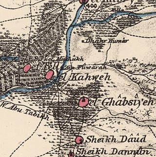
Al-Ghabisiyya was a Palestinian Arab village in northern Palestine, 16 km north-east of Acre in present-day Israel. It was depopulated by the Israel Defense Forces during the 1948 Palestinian expulsion and remains deserted.
Munirka is now an urban village in South Delhi, located near Jawaharlal Nehru University and Indian Institute of Technology Delhi campuse. Munirka villagers small lands was reacquired by the central government because of illegal occupation and baseless claims. Its neighborhood consists of the Jawaharlal Nehru University campus on the south, Vasant vihar on the northwest, R.K. Puram on the northern side and the Indian Institute of Technology Delhi campus and Ber Sarai on south-eastern front. The outer ring road forms the north to the east boundary of this and also making it accessible. This is near flyover.
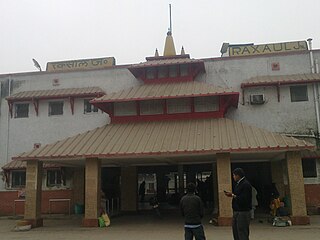
Raxaul is a sub-divisional town in the East Champaran district of the Indian state of Bihar. It is situated at the India-Nepal border with Birgunj city (Nepal). Raxaul is a major railway junction.
Gokal Pur also known as village gokalpur is a census town in North East district in the Indian state of Delhi. Gokal Pur village is founded by a gujjar more than 900 years ago( exact time/date is not known). There were two Jindhad Gotra (Gurjar) brothers, one is Gokal and other is Johri. Gokal establish village Gokalpur and Johri established village Johripur. The present population majorly includes Gurjars, Pandits Rajputs, Sain
Kapashera is the administrative headquarters and one of the three sub-division of the South West district of Delhi NCT, India. The office of deputy commissioner is located at Old Tax Terminal building.
Uchana is a developing town and a municipal committee, near city of Jind in Jind district in the Indian state of Haryana.
Dwarka is a neighbourhood located in Southwestern edge of Indian Capital New Delhi in South West Delhi district of the NCT of Delhi. The district court that functions under the Delhi High Court for South West Delhi is located in Dwarka.

The Delhi Development Authority (DDA) is a statutory body established under the Delhi Development Act, 1957, under the jurisdiction of the Ministry of Housing and Urban Affairs, Government of India to "promote and secure the development of Delhi". It is tasked with large-scale land acquisition for affordable housing in Delhi, as well as planning, development and construction of residential projects and commercial lands. Its responsibilities included providing public facilities like roads, bridges, drains, underground water reservoirs, community centres, sports centres, and green belts within the National Capital Territory of Delhi, India.
Nangal Choudhary is an Important Town and a Sub Division in District Mahendragarh near Narnaul in India, within the National Capital Region of India. It comes in Ahirwal region. It is a municipal committee in Mahendragarh district.

Noida International Airport, also known as Jewar Airport, is an upcoming international airport being constructed near Jewar in Gautam Buddha Nagar district, Uttar Pradesh, India, which will serve the National Capital Region (NCR). The airport is situated in the new planned YEIDA city.

Manesar is a town and municipal corporation, known as New gurgaon city in the Gurugram district of the state of Haryana, India and a part of the National Capital Region (NCR) of Delhi. It is an Industrial Model Township home to factories and industrial activity from multinational corporations.
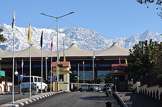
Kangra-Gaggal Airport, officially known as Kangra Airport, is a domestic airport serving areas of Kangra including Dharamshala, the winter capital of Himachal Pradesh, India. It is located at Gaggal, which is situated 12 km (7.5 mi) from the city, 8 km (5.0 mi) from Kangra and 14 km (8.7 mi) from Kangra Railway Station. The airport is located on National Highway 154, that runs between Pathankot and Mandi, and is the largest airport in Himachal Pradesh in terms of passengers and aircraft movement, handling over 200,000 passengers and over 4,200 aircraft in FY 2023-24.

Salem Airport is a domestic airport serving the city of Salem, along with neighboring cities of Erode and Karur, in Tamil Nadu, India. It is located at Kamalapuram in Omalur taluk, 19 km (12 mi) north-west from the city centre. It was the sixth-busiest airport in Tamil Nadu after Chennai, Coimbatore, Tiruchirappalli, Madurai, and Tuticorin airports. It is also the fifth-largest airport in Tamil Nadu in terms of runway length.

Sultan Ghari was the first Islamic Mausoleum (tomb) built in 1231 AD for Prince Nasiruddin Mahmud, eldest son of Iltumish, in the "funerary landscape of Delhi" in the Nangal Dewat Forest, Near Nangal Dewat Vasant Kunj).
Narela is a Suburb and a Tehsil of Delhi, located in the North Delhi district of Delhi, close to the border of Haryana. Narela is a part of North Delhi. It is 30 km away from the city centre of New Delhi.
NH 248-BB, commonly known as Dwarka Expressway is a 27.6 km (17.1 mi) long, under construction, 8-lane (elevated) and 8-lane, total 16-lane elevated grade separated expressway connecting Dwarka in Delhi to Kherki Daula Toll Plaza, Gurgaon in Haryana. The expressway takes off from km 20 milestone of NH 48 at Shiv Murti in Mahipalpur in Delhi and terminate at km 40 of NH 48 near Kherki Daula Toll Plaza in Gurgaon in Haryana. The Dwarka Expressway has been planned as an alternate road link between Delhi and Gurgaon, and is expected to ease the traffic situation on the Delhi–Gurgaon Expressway.
Devinder Kumar Sehrawat is a retired colonel of the Indian Armed Forces, farmer advocate, and politician. As a former Member of the Sixth Legislative Assembly of Delhi. He represented the Bijwasan constituency of New Delhi, championing the causes of the marginalized and underprivileged.

Hindon Airport, also spelled Hindan Airport, is a commercial domestic airport and an Indian Air Force base in Ghaziabad, Uttar Pradesh, India, operated by the Airports Authority of India at Hindan Air Force Station of the Indian Air Force. It is the second commercial airport serving the National Capital Region after Indira Gandhi International Airport in Delhi and 20 km from Connaught Place.
Mahipalpur on National Highway - 8, leading to Gurugram and Jaipur has ancient roots and it is amongst the oldest villages of India. It is located at the edge of south central ridge of 1500 million year old Aravali Hills; It is bound by the South Central Ridge in the North East, Vasant Kunj towards East, Shankar Vihar towards North, National Highway -8 towards North West and Rangpuri village toward South West. Currently the most popular hotel and guest house destination in Delhi. In revenue department record it is an urban village, located in New Delhi district of Delhi, India. It is located near the Indira Gandhi International Airport. Delhi Aerocity metro station is the nearest metro station.
New Chennai Greenfield International Airport is a proposed greenfield airport project to serve the city of Chennai, Tamil Nadu, India. It will be built near Parandur of Kanchipuram district in the Indian state of Tamil Nadu. It will serve the city alongside the existing Chennai International Airport. The proposed airport will be spread around 5,000 acres. The Government of Tamil Nadu has declared that Tamil Nadu Industrial Development Corporation (TIDCO) will lead the project. The Airports Authority of India (AAI) conducted surveys on various areas near Chennai for a new airport for the city. Initially, a site near Sriperumbudur was fixed for the airport. But due to delays and cost of the land, the government decided to set the new airport in Parandur. The airport will also boost trade from Chennai and neighbouring districts as it will have its own dedicated cargo terminal, leading to a rapid increase in the economic development of the state.

